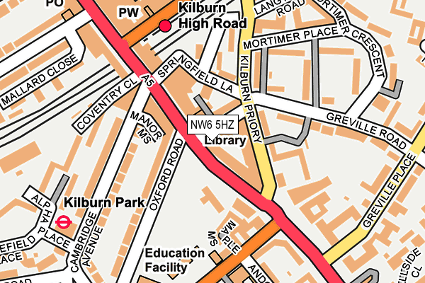
NW6 5HZ is located in the Kilburn electoral ward, within the London borough of Camden and the English Parliamentary constituency of Hampstead and Kilburn. The Sub Integrated Care Board (ICB) Location is NHS North Central London ICB - 93C and the police force is Metropolitan Police. This postcode has been in use since June 1996.


GetTheData
Source: OS OpenMap – Local (Ordnance Survey)
Source: OS VectorMap District (Ordnance Survey)
Licence: Open Government Licence (requires attribution)
| Easting | 525572 |
| Northing | 183462 |
| Latitude | 51.536104 |
| Longitude | -0.190885 |
GetTheData
Source: Open Postcode Geo
Licence: Open Government Licence
| Country | England |
| Postcode District | NW6 |
➜ See where NW6 is on a map ➜ Where is Hampstead? | |
GetTheData
Source: Land Registry Price Paid Data
Licence: Open Government Licence
Elevation or altitude of NW6 5HZ as distance above sea level:
| Metres | Feet | |
|---|---|---|
| Elevation | 30m | 98ft |
Elevation is measured from the approximate centre of the postcode, to the nearest point on an OS contour line from OS Terrain 50, which has contour spacing of ten vertical metres.
➜ How high above sea level am I? Find the elevation of your current position using your device's GPS.
GetTheData
Source: Open Postcode Elevation
Licence: Open Government Licence
| Ward | Kilburn |
| Constituency | Hampstead And Kilburn |
GetTheData
Source: ONS Postcode Database
Licence: Open Government Licence
| Kilburn High Road Station (Kilburn High Road) | Kilburn | 57m |
| Kilburn High Road Station | Kilburn | 76m |
| Kilburn High Rd Cambridge Ave | Kilburn | 113m |
| Kilburn High Road Station | Kilburn | 128m |
| Kilburn Park (Cambridge Avenue) | Kilburn Park | 179m |
| Kilburn Park Underground Station | Kilburn Park | 264m |
| Maida Vale Underground Station | Maida Vale | 789m |
| Queen's Park Underground Station | Queen's Park | 974m |
| West Hampstead Underground Station | West Hampstead | 1,172m |
| St. John's Wood Underground Station | St Johns Wood | 1,188m |
| Kilburn High Road Station | 0.2km |
| Queens Park (London) Station | 1km |
| South Hampstead Station | 1km |
GetTheData
Source: NaPTAN
Licence: Open Government Licence
GetTheData
Source: ONS Postcode Database
Licence: Open Government Licence


➜ Get more ratings from the Food Standards Agency
GetTheData
Source: Food Standards Agency
Licence: FSA terms & conditions
| Last Collection | |||
|---|---|---|---|
| Location | Mon-Fri | Sat | Distance |
| High Road | 18:30 | 12:00 | 48m |
| Kilburn Delivery Office | 18:30 | 12:00 | 195m |
| Maida Vale | 17:30 | 12:00 | 203m |
GetTheData
Source: Dracos
Licence: Creative Commons Attribution-ShareAlike
The below table lists the International Territorial Level (ITL) codes (formerly Nomenclature of Territorial Units for Statistics (NUTS) codes) and Local Administrative Units (LAU) codes for NW6 5HZ:
| ITL 1 Code | Name |
|---|---|
| TLI | London |
| ITL 2 Code | Name |
| TLI3 | Inner London - West |
| ITL 3 Code | Name |
| TLI31 | Camden and City of London |
| LAU 1 Code | Name |
| E09000007 | Camden |
GetTheData
Source: ONS Postcode Directory
Licence: Open Government Licence
The below table lists the Census Output Area (OA), Lower Layer Super Output Area (LSOA), and Middle Layer Super Output Area (MSOA) for NW6 5HZ:
| Code | Name | |
|---|---|---|
| OA | E00004610 | |
| LSOA | E01000930 | Camden 020B |
| MSOA | E02000185 | Camden 020 |
GetTheData
Source: ONS Postcode Directory
Licence: Open Government Licence
| NW6 5HT | Greville Road | 0m |
| NW6 5HU | Greville Road | 41m |
| NW6 5NJ | Kilburn Priory | 49m |
| NW6 5HX | Greville Mews | 50m |
| NW6 5HY | Greville Road | 52m |
| NW6 5UB | Springfield Lane | 67m |
| NW6 5UA | Kilburn High Road | 68m |
| NW6 5SB | Kilburn High Road | 71m |
| NW6 5UX | Kilburn Priory | 75m |
| NW6 5SG | Tollgate Gardens | 86m |
GetTheData
Source: Open Postcode Geo; Land Registry Price Paid Data
Licence: Open Government Licence