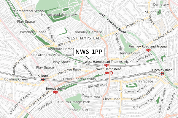
NW6 1PP lies on Sumatra Road in London. NW6 1PP is located in the West Hampstead electoral ward, within the London borough of Camden and the English Parliamentary constituency of Hampstead and Kilburn. The Sub Integrated Care Board (ICB) Location is NHS North Central London ICB - 93C and the police force is Metropolitan Police. This postcode has been in use since January 1980.


GetTheData
Source: OS Open Zoomstack (Ordnance Survey)
Licence: Open Government Licence (requires attribution)
Attribution: Contains OS data © Crown copyright and database right 2025
Source: Open Postcode Geo
Licence: Open Government Licence (requires attribution)
Attribution: Contains OS data © Crown copyright and database right 2025; Contains Royal Mail data © Royal Mail copyright and database right 2025; Source: Office for National Statistics licensed under the Open Government Licence v.3.0
| Easting | 525236 |
| Northing | 184924 |
| Latitude | 51.549317 |
| Longitude | -0.195207 |
GetTheData
Source: Open Postcode Geo
Licence: Open Government Licence
| Street | Sumatra Road |
| Town/City | London |
| Country | England |
| Postcode District | NW6 |
➜ See where NW6 is on a map ➜ Where is Hampstead? | |
GetTheData
Source: Land Registry Price Paid Data
Licence: Open Government Licence
Elevation or altitude of NW6 1PP as distance above sea level:
| Metres | Feet | |
|---|---|---|
| Elevation | 50m | 164ft |
Elevation is measured from the approximate centre of the postcode, to the nearest point on an OS contour line from OS Terrain 50, which has contour spacing of ten vertical metres.
➜ How high above sea level am I? Find the elevation of your current position using your device's GPS.
GetTheData
Source: Open Postcode Elevation
Licence: Open Government Licence
| Ward | West Hampstead |
| Constituency | Hampstead And Kilburn |
GetTheData
Source: ONS Postcode Database
Licence: Open Government Licence
| Dennington Park Road | West Hampstead | 252m |
| Dennington Park Road | West Hampstead | 267m |
| West Hampstead Thameslink Rail Station | West Hampstead | 300m |
| Mill Lane West Hampstead | West Hampstead | 300m |
| Fortune Green Road West Hampstead | West Hampstead | 308m |
| West Hampstead Underground Station | West Hampstead | 414m |
| Kilburn Underground Station | Brondesbury | 678m |
| Finchley Road Underground Station | Finchley Road | 1,101m |
| Hampstead Underground Station | Hampstead | 1,416m |
| Swiss Cottage Underground Station | Swiss Cottage | 1,542m |
| West Hampstead Thameslink Station | 0.3km |
| West Hampstead Station | 0.3km |
| Brondesbury Station | 0.7km |
GetTheData
Source: NaPTAN
Licence: Open Government Licence
| Percentage of properties with Next Generation Access | 100.0% |
| Percentage of properties with Superfast Broadband | 100.0% |
| Percentage of properties with Ultrafast Broadband | 100.0% |
| Percentage of properties with Full Fibre Broadband | 0.0% |
Superfast Broadband is between 30Mbps and 300Mbps
Ultrafast Broadband is > 300Mbps
| Percentage of properties unable to receive 2Mbps | 0.0% |
| Percentage of properties unable to receive 5Mbps | 0.0% |
| Percentage of properties unable to receive 10Mbps | 0.0% |
| Percentage of properties unable to receive 30Mbps | 0.0% |
GetTheData
Source: Ofcom
Licence: Ofcom Terms of Use (requires attribution)
GetTheData
Source: ONS Postcode Database
Licence: Open Government Licence


➜ Get more ratings from the Food Standards Agency
GetTheData
Source: Food Standards Agency
Licence: FSA terms & conditions
| Last Collection | |||
|---|---|---|---|
| Location | Mon-Fri | Sat | Distance |
| Pandora Road | 17:30 | 12:00 | 47m |
| Maygrove Road | 17:30 | 12:00 | 175m |
| Kingdon Road | 17:30 | 12:00 | 214m |
GetTheData
Source: Dracos
Licence: Creative Commons Attribution-ShareAlike
The below table lists the International Territorial Level (ITL) codes (formerly Nomenclature of Territorial Units for Statistics (NUTS) codes) and Local Administrative Units (LAU) codes for NW6 1PP:
| ITL 1 Code | Name |
|---|---|
| TLI | London |
| ITL 2 Code | Name |
| TLI3 | Inner London - West |
| ITL 3 Code | Name |
| TLI31 | Camden and City of London |
| LAU 1 Code | Name |
| E09000007 | Camden |
GetTheData
Source: ONS Postcode Directory
Licence: Open Government Licence
The below table lists the Census Output Area (OA), Lower Layer Super Output Area (LSOA), and Middle Layer Super Output Area (MSOA) for NW6 1PP:
| Code | Name | |
|---|---|---|
| OA | E00004821 | |
| LSOA | E01000970 | Camden 010B |
| MSOA | E02000175 | Camden 010 |
GetTheData
Source: ONS Postcode Directory
Licence: Open Government Licence
| NW6 1PN | Sumatra Road | 49m |
| NW6 1TS | Pandora Road | 56m |
| NW6 1TR | Pandora Road | 58m |
| NW6 1PL | Sumatra Road | 63m |
| NW6 1BD | Dennington Park Road | 65m |
| NW6 1BB | Dennington Park Road | 92m |
| NW6 1TT | Pandora Road | 106m |
| NW6 1TU | Solent Road | 115m |
| NW6 1PJ | Kingdon Road | 122m |
| NW6 1TP | Solent Road | 124m |
GetTheData
Source: Open Postcode Geo; Land Registry Price Paid Data
Licence: Open Government Licence