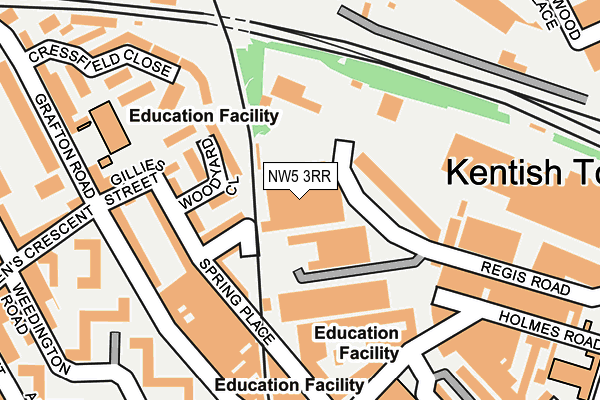
NW5 3RR is located in the Kentish Town South electoral ward, within the London borough of Camden and the English Parliamentary constituency of Holborn and St Pancras. The Sub Integrated Care Board (ICB) Location is NHS North Central London ICB - 93C and the police force is Metropolitan Police. This postcode has been in use since January 1995.


GetTheData
Source: OS OpenMap – Local (Ordnance Survey)
Source: OS VectorMap District (Ordnance Survey)
Licence: Open Government Licence (requires attribution)
| Easting | 528593 |
| Northing | 185177 |
| Latitude | 51.550837 |
| Longitude | -0.146726 |
GetTheData
Source: Open Postcode Geo
Licence: Open Government Licence
| Country | England |
| Postcode District | NW5 |
➜ See where NW5 is on a map ➜ Where is London? | |
GetTheData
Source: Land Registry Price Paid Data
Licence: Open Government Licence
Elevation or altitude of NW5 3RR as distance above sea level:
| Metres | Feet | |
|---|---|---|
| Elevation | 40m | 131ft |
Elevation is measured from the approximate centre of the postcode, to the nearest point on an OS contour line from OS Terrain 50, which has contour spacing of ten vertical metres.
➜ How high above sea level am I? Find the elevation of your current position using your device's GPS.
GetTheData
Source: Open Postcode Elevation
Licence: Open Government Licence
| Ward | Kentish Town South |
| Constituency | Holborn And St Pancras |
GetTheData
Source: ONS Postcode Database
Licence: Open Government Licence
| Kentish Town Fire Station (Highgate Road) | Kentish Town | 378m |
| Lady Somerset Road Gospel Oak (Highgate Road) | Gospel Oak | 383m |
| Kentish Town Fire Station (Highgate Road) | Kentish Town | 384m |
| Fortess Road (Highgate Road) | Kentish Town | 389m |
| Kentish Town (Kentish Town Road) | Kentish Town | 403m |
| Kentish Town Underground Station | Kentish Town | 420m |
| Chalk Farm Underground Station | Chalk Farm | 879m |
| Tufnell Park Underground Station | Tufnell Park | 880m |
| Belsize Park Underground Station | Belsize Park | 1,244m |
| Camden Town Underground Station | Camden Town | 1,314m |
| Kentish Town Station | 0.4km |
| Kentish Town West Station | 0.5km |
| Gospel Oak Station | 0.6km |
GetTheData
Source: NaPTAN
Licence: Open Government Licence
GetTheData
Source: ONS Postcode Database
Licence: Open Government Licence


➜ Get more ratings from the Food Standards Agency
GetTheData
Source: Food Standards Agency
Licence: FSA terms & conditions
| Last Collection | |||
|---|---|---|---|
| Location | Mon-Fri | Sat | Distance |
| Kentish Town Delivery Office | 18:00 | 12:00 | 192m |
| Grafton Road | 17:30 | 12:00 | 264m |
| Queens Crescent Post Office | 17:30 | 12:00 | 411m |
GetTheData
Source: Dracos
Licence: Creative Commons Attribution-ShareAlike
The below table lists the International Territorial Level (ITL) codes (formerly Nomenclature of Territorial Units for Statistics (NUTS) codes) and Local Administrative Units (LAU) codes for NW5 3RR:
| ITL 1 Code | Name |
|---|---|
| TLI | London |
| ITL 2 Code | Name |
| TLI3 | Inner London - West |
| ITL 3 Code | Name |
| TLI31 | Camden and City of London |
| LAU 1 Code | Name |
| E09000007 | Camden |
GetTheData
Source: ONS Postcode Directory
Licence: Open Government Licence
The below table lists the Census Output Area (OA), Lower Layer Super Output Area (LSOA), and Middle Layer Super Output Area (MSOA) for NW5 3RR:
| Code | Name | |
|---|---|---|
| OA | E00004563 | |
| LSOA | E01000922 | Camden 007E |
| MSOA | E02000172 | Camden 007 |
GetTheData
Source: ONS Postcode Directory
Licence: Open Government Licence
| NW5 4BX | Woodyard Close | 82m |
| NW5 4DJ | Arctic Street | 96m |
| NW5 3BB | Spring Place | 107m |
| NW5 3EX | Browns Lane | 110m |
| NW5 4DN | Gillies Street | 112m |
| NW5 4BU | Woodyard Close | 125m |
| NW5 4DL | Gillies Street | 139m |
| NW5 4BA | Grafton Road | 164m |
| NW5 3AY | Holmes Road | 175m |
| NW5 3AT | Holmes Road | 181m |
GetTheData
Source: Open Postcode Geo; Land Registry Price Paid Data
Licence: Open Government Licence