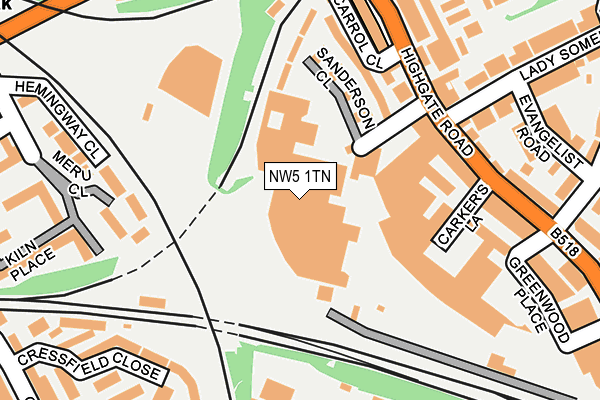
NW5 1TN is located in the Kentish Town North electoral ward, within the London borough of Camden and the English Parliamentary constituency of Holborn and St Pancras. The Sub Integrated Care Board (ICB) Location is NHS North Central London ICB - 93C and the police force is Metropolitan Police. This postcode has been in use since January 1980.


GetTheData
Source: OS OpenMap – Local (Ordnance Survey)
Source: OS VectorMap District (Ordnance Survey)
Licence: Open Government Licence (requires attribution)
| Easting | 528604 |
| Northing | 185480 |
| Latitude | 51.553557 |
| Longitude | -0.146457 |
GetTheData
Source: Open Postcode Geo
Licence: Open Government Licence
| Country | England |
| Postcode District | NW5 |
➜ See where NW5 is on a map ➜ Where is London? | |
GetTheData
Source: Land Registry Price Paid Data
Licence: Open Government Licence
Elevation or altitude of NW5 1TN as distance above sea level:
| Metres | Feet | |
|---|---|---|
| Elevation | 40m | 131ft |
Elevation is measured from the approximate centre of the postcode, to the nearest point on an OS contour line from OS Terrain 50, which has contour spacing of ten vertical metres.
➜ How high above sea level am I? Find the elevation of your current position using your device's GPS.
GetTheData
Source: Open Postcode Elevation
Licence: Open Government Licence
| Ward | Kentish Town North |
| Constituency | Holborn And St Pancras |
GetTheData
Source: ONS Postcode Database
Licence: Open Government Licence
| Lady Somerset Road Gospel Oak (Highgate Road) | Gospel Oak | 176m |
| Lady Somerset Road Gospel Oak (Highgate Road) | Gospel Oak | 215m |
| Kentish Town Fire Station (Highgate Road) | Kentish Town | 222m |
| Kentish Town Fire Station (Highgate Road) | Kentish Town | 285m |
| Gordon House Road (Highgate Road) | Gospel Oak | 285m |
| Kentish Town Underground Station | Kentish Town | 537m |
| Tufnell Park Underground Station | Tufnell Park | 664m |
| Chalk Farm Underground Station | Chalk Farm | 1,155m |
| Belsize Park Underground Station | Belsize Park | 1,312m |
| Archway Underground Station | Archway | 1,552m |
| Gospel Oak Station | 0.4km |
| Kentish Town Station | 0.5km |
| Kentish Town West Station | 0.8km |
GetTheData
Source: NaPTAN
Licence: Open Government Licence
GetTheData
Source: ONS Postcode Database
Licence: Open Government Licence


➜ Get more ratings from the Food Standards Agency
GetTheData
Source: Food Standards Agency
Licence: FSA terms & conditions
| Last Collection | |||
|---|---|---|---|
| Location | Mon-Fri | Sat | Distance |
| Lamble Road | 17:30 | 12:00 | 290m |
| Lissenden Gardens | 17:30 | 12:00 | 302m |
| 7 Fortess Road | 17:30 | 12:00 | 389m |
GetTheData
Source: Dracos
Licence: Creative Commons Attribution-ShareAlike
The below table lists the International Territorial Level (ITL) codes (formerly Nomenclature of Territorial Units for Statistics (NUTS) codes) and Local Administrative Units (LAU) codes for NW5 1TN:
| ITL 1 Code | Name |
|---|---|
| TLI | London |
| ITL 2 Code | Name |
| TLI3 | Inner London - West |
| ITL 3 Code | Name |
| TLI31 | Camden and City of London |
| LAU 1 Code | Name |
| E09000007 | Camden |
GetTheData
Source: ONS Postcode Directory
Licence: Open Government Licence
The below table lists the Census Output Area (OA), Lower Layer Super Output Area (LSOA), and Middle Layer Super Output Area (MSOA) for NW5 1TN:
| Code | Name | |
|---|---|---|
| OA | E00004584 | |
| LSOA | E01000928 | Camden 003E |
| MSOA | E02000168 | Camden 003 |
GetTheData
Source: ONS Postcode Directory
Licence: Open Government Licence
| NW5 1TS | Sanderson Close | 134m |
| NW5 1TF | Carrol Close | 157m |
| NW5 1PA | Highgate Road | 185m |
| NW5 1TR | Highgate Road | 191m |
| NW5 1LB | Greenwood Place | 194m |
| NW5 1TY | Lady Somerset Road | 210m |
| NW5 1NX | College Yard | 210m |
| NW5 1RT | 210m | |
| NW5 4BN | Cressfield Close | 211m |
| NW5 1PB | Highgate Road | 214m |
GetTheData
Source: Open Postcode Geo; Land Registry Price Paid Data
Licence: Open Government Licence