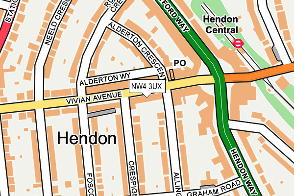
NW4 3UX lies on Vivian Avenue in London. NW4 3UX is located in the West Hendon electoral ward, within the London borough of Barnet and the English Parliamentary constituency of Hendon. The Sub Integrated Care Board (ICB) Location is NHS North Central London ICB - 93C and the police force is Metropolitan Police. This postcode has been in use since January 1980.


GetTheData
Source: OS OpenMap – Local (Ordnance Survey)
Source: OS VectorMap District (Ordnance Survey)
Licence: Open Government Licence (requires attribution)
| Easting | 522787 |
| Northing | 188545 |
| Latitude | 51.582400 |
| Longitude | -0.229220 |
GetTheData
Source: Open Postcode Geo
Licence: Open Government Licence
| Street | Vivian Avenue |
| Town/City | London |
| Country | England |
| Postcode District | NW4 |
➜ See where NW4 is on a map ➜ Where is Hendon? | |
GetTheData
Source: Land Registry Price Paid Data
Licence: Open Government Licence
Elevation or altitude of NW4 3UX as distance above sea level:
| Metres | Feet | |
|---|---|---|
| Elevation | 70m | 230ft |
Elevation is measured from the approximate centre of the postcode, to the nearest point on an OS contour line from OS Terrain 50, which has contour spacing of ten vertical metres.
➜ How high above sea level am I? Find the elevation of your current position using your device's GPS.
GetTheData
Source: Open Postcode Elevation
Licence: Open Government Licence
| Ward | West Hendon |
| Constituency | Hendon |
GetTheData
Source: ONS Postcode Database
Licence: Open Government Licence
| Hendon Way | Hendon | 71m |
| Hendon Way | Hendon | 89m |
| Hendon Central (Watford Way) | Hendon Central | 147m |
| Hendon Central (Watford Way) | Hendon Central | 172m |
| Hendon Central (Watford Way) | Hendon Central | 186m |
| Hendon Central Underground Station | Hendon Central | 220m |
| Brent Cross Underground Station | Brent Cross | 1,258m |
| Colindale Underground Station | Colindale | 2,038m |
| Hendon Station | 0.7km |
| Cricklewood Station | 2.9km |
| Mill Hill Broadway Station | 3.7km |
GetTheData
Source: NaPTAN
Licence: Open Government Licence
GetTheData
Source: ONS Postcode Database
Licence: Open Government Licence


➜ Get more ratings from the Food Standards Agency
GetTheData
Source: Food Standards Agency
Licence: FSA terms & conditions
| Last Collection | |||
|---|---|---|---|
| Location | Mon-Fri | Sat | Distance |
| Hendon Central Post Office | 17:30 | 12:00 | 96m |
| 20 Watford Way | 17:30 | 12:00 | 184m |
| Neeld Crescent | 17:30 | 12:00 | 206m |
GetTheData
Source: Dracos
Licence: Creative Commons Attribution-ShareAlike
The below table lists the International Territorial Level (ITL) codes (formerly Nomenclature of Territorial Units for Statistics (NUTS) codes) and Local Administrative Units (LAU) codes for NW4 3UX:
| ITL 1 Code | Name |
|---|---|
| TLI | London |
| ITL 2 Code | Name |
| TLI7 | Outer London - West and North West |
| ITL 3 Code | Name |
| TLI71 | Barnet |
| LAU 1 Code | Name |
| E09000003 | Barnet |
GetTheData
Source: ONS Postcode Directory
Licence: Open Government Licence
The below table lists the Census Output Area (OA), Lower Layer Super Output Area (LSOA), and Middle Layer Super Output Area (MSOA) for NW4 3UX:
| Code | Name | |
|---|---|---|
| OA | E00001536 | |
| LSOA | E01000314 | Barnet 032F |
| MSOA | E02000055 | Barnet 032 |
GetTheData
Source: ONS Postcode Directory
Licence: Open Government Licence
| NW4 3UY | Vivian Avenue | 9m |
| NW4 3XP | Vivian Avenue | 39m |
| NW4 3XR | Vivian Avenue | 39m |
| NW4 3UT | Vivian Avenue | 72m |
| NW4 3XJ | Vivian Avenue | 74m |
| NW4 3YD | Vivian Avenue | 78m |
| NW4 3YA | Vivian Avenue | 88m |
| NW4 3XD | Vivian Avenue | 90m |
| NW4 3XH | Vivian Avenue | 93m |
| NW4 3XT | Alderton Crescent | 93m |
GetTheData
Source: Open Postcode Geo; Land Registry Price Paid Data
Licence: Open Government Licence