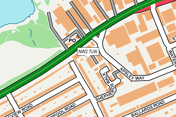
NW2 7LW lies on Harp Business Centre in London. NW2 7LW is located in the Dollis Hill electoral ward, within the London borough of Brent and the English Parliamentary constituency of Brent Central. The Sub Integrated Care Board (ICB) Location is NHS North West London ICB - W2U3Z and the police force is Metropolitan Police. This postcode has been in use since August 1992.


GetTheData
Source: OS OpenMap – Local (Ordnance Survey)
Source: OS VectorMap District (Ordnance Survey)
Licence: Open Government Licence (requires attribution)
| Easting | 521995 |
| Northing | 186928 |
| Latitude | 51.568037 |
| Longitude | -0.241231 |
GetTheData
Source: Open Postcode Geo
Licence: Open Government Licence
| Street | Harp Business Centre |
| Town/City | London |
| Country | England |
| Postcode District | NW2 |
➜ See where NW2 is on a map ➜ Where is London? | |
GetTheData
Source: Land Registry Price Paid Data
Licence: Open Government Licence
Elevation or altitude of NW2 7LW as distance above sea level:
| Metres | Feet | |
|---|---|---|
| Elevation | 50m | 164ft |
Elevation is measured from the approximate centre of the postcode, to the nearest point on an OS contour line from OS Terrain 50, which has contour spacing of ten vertical metres.
➜ How high above sea level am I? Find the elevation of your current position using your device's GPS.
GetTheData
Source: Open Postcode Elevation
Licence: Open Government Licence
| Ward | Dollis Hill |
| Constituency | Brent Central |
GetTheData
Source: ONS Postcode Database
Licence: Open Government Licence
| Brook Road | Dollis Hill | 71m |
| Brook Road | Dollis Hill | 101m |
| Coles Green Rd North Circular | Dollis Hill | 307m |
| Waterloo Rd North Circular Rd | Dollis Hill | 344m |
| Heather Road (Nw2) | Neasden | 383m |
| Hendon Station | 1.3km |
| Cricklewood Station | 2.2km |
| Wembley Stadium Station | 3.4km |
GetTheData
Source: NaPTAN
Licence: Open Government Licence
| Median download speed | 79.9Mbps |
| Average download speed | 55.7Mbps |
| Maximum download speed | 80.00Mbps |
| Median upload speed | 19.0Mbps |
| Average upload speed | 14.3Mbps |
| Maximum upload speed | 20.00Mbps |
GetTheData
Source: Ofcom
Licence: Ofcom Terms of Use (requires attribution)
GetTheData
Source: ONS Postcode Database
Licence: Open Government Licence


➜ Get more ratings from the Food Standards Agency
GetTheData
Source: Food Standards Agency
Licence: FSA terms & conditions
| Last Collection | |||
|---|---|---|---|
| Location | Mon-Fri | Sat | Distance |
| Dawpool Road | 17:30 | 12:00 | 316m |
| 22 Ballards Road | 17:30 | 12:00 | 336m |
| 89 Crest Road | 17:30 | 12:00 | 394m |
GetTheData
Source: Dracos
Licence: Creative Commons Attribution-ShareAlike
The below table lists the International Territorial Level (ITL) codes (formerly Nomenclature of Territorial Units for Statistics (NUTS) codes) and Local Administrative Units (LAU) codes for NW2 7LW:
| ITL 1 Code | Name |
|---|---|
| TLI | London |
| ITL 2 Code | Name |
| TLI7 | Outer London - West and North West |
| ITL 3 Code | Name |
| TLI72 | Brent |
| LAU 1 Code | Name |
| E09000005 | Brent |
GetTheData
Source: ONS Postcode Directory
Licence: Open Government Licence
The below table lists the Census Output Area (OA), Lower Layer Super Output Area (LSOA), and Middle Layer Super Output Area (MSOA) for NW2 7LW:
| Code | Name | |
|---|---|---|
| OA | E00002427 | |
| LSOA | E01000498 | Brent 010B |
| MSOA | E02000102 | Brent 010 |
GetTheData
Source: ONS Postcode Directory
Licence: Open Government Licence
| NW2 7JX | North Circular Road | 41m |
| NW2 7AY | North Circular Road | 82m |
| NW2 7BS | Shepherds Walk | 101m |
| NW2 7AX | North Circular Road | 128m |
| NW2 7BJ | Brook Road | 129m |
| NW2 7TE | North Circular Road | 182m |
| NW2 7BD | Review Road | 184m |
| NW2 7BH | Review Road | 185m |
| NW2 7JY | Dawpool Road | 199m |
| NW2 7AH | North Circular Road | 205m |
GetTheData
Source: Open Postcode Geo; Land Registry Price Paid Data
Licence: Open Government Licence