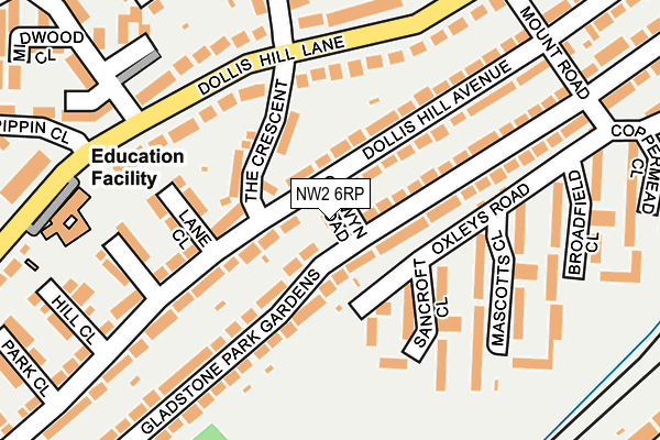
NW2 6RP lies on Colwyn Road in London. NW2 6RP is located in the Dollis Hill electoral ward, within the London borough of Brent and the English Parliamentary constituency of Brent Central. The Sub Integrated Care Board (ICB) Location is NHS North West London ICB - W2U3Z and the police force is Metropolitan Police. This postcode has been in use since January 1980.


GetTheData
Source: OS OpenMap – Local (Ordnance Survey)
Source: OS VectorMap District (Ordnance Survey)
Licence: Open Government Licence (requires attribution)
| Easting | 522820 |
| Northing | 186213 |
| Latitude | 51.561432 |
| Longitude | -0.229584 |
GetTheData
Source: Open Postcode Geo
Licence: Open Government Licence
| Street | Colwyn Road |
| Town/City | London |
| Country | England |
| Postcode District | NW2 |
➜ See where NW2 is on a map ➜ Where is London? | |
GetTheData
Source: Land Registry Price Paid Data
Licence: Open Government Licence
Elevation or altitude of NW2 6RP as distance above sea level:
| Metres | Feet | |
|---|---|---|
| Elevation | 60m | 197ft |
Elevation is measured from the approximate centre of the postcode, to the nearest point on an OS contour line from OS Terrain 50, which has contour spacing of ten vertical metres.
➜ How high above sea level am I? Find the elevation of your current position using your device's GPS.
GetTheData
Source: Open Postcode Elevation
Licence: Open Government Licence
| Ward | Dollis Hill |
| Constituency | Brent Central |
GetTheData
Source: ONS Postcode Database
Licence: Open Government Licence
| The Crescentdollis Hill Lane | Dollis Hill | 165m |
| Newfield Rise (Dollis Hill Lane) | Dollis Hill | 172m |
| Oxgate Gardens | Dollis Hill | 181m |
| Pippin Close (Dollis Hill Lane) | Dollis Hill | 277m |
| Parkside (Nw2) (Dollis Hill Lane) | Dollis Hill | 292m |
| Dollis Hill Underground Station | Dudden Hill | 1,243m |
| Willesden Green Underground Station | Willesden Green | 1,476m |
| Neasden Underground Station | Neasden | 1,630m |
| Cricklewood Station | 1.2km |
| Hendon Station | 2.2km |
| Brondesbury Station | 2.6km |
GetTheData
Source: NaPTAN
Licence: Open Government Licence
| Percentage of properties with Next Generation Access | 100.0% |
| Percentage of properties with Superfast Broadband | 100.0% |
| Percentage of properties with Ultrafast Broadband | 0.0% |
| Percentage of properties with Full Fibre Broadband | 0.0% |
Superfast Broadband is between 30Mbps and 300Mbps
Ultrafast Broadband is > 300Mbps
| Percentage of properties unable to receive 2Mbps | 0.0% |
| Percentage of properties unable to receive 5Mbps | 0.0% |
| Percentage of properties unable to receive 10Mbps | 0.0% |
| Percentage of properties unable to receive 30Mbps | 0.0% |
GetTheData
Source: Ofcom
Licence: Ofcom Terms of Use (requires attribution)
Estimated total energy consumption in NW2 6RP by fuel type, 2015.
| Consumption (kWh) | 121,313 |
|---|---|
| Meter count | 6 |
| Mean (kWh/meter) | 20,219 |
| Median (kWh/meter) | 18,361 |
GetTheData
Source: Postcode level gas estimates: 2015 (experimental)
Source: Postcode level electricity estimates: 2015 (experimental)
Licence: Open Government Licence
GetTheData
Source: ONS Postcode Database
Licence: Open Government Licence


➜ Get more ratings from the Food Standards Agency
GetTheData
Source: Food Standards Agency
Licence: FSA terms & conditions
| Last Collection | |||
|---|---|---|---|
| Location | Mon-Fri | Sat | Distance |
| Gladstone Park Gardens | 17:30 | 12:00 | 33m |
| Dollis Hill Lane | 17:30 | 12:00 | 161m |
| Cambell Gordon Way | 17:30 | 12:00 | 377m |
GetTheData
Source: Dracos
Licence: Creative Commons Attribution-ShareAlike
The below table lists the International Territorial Level (ITL) codes (formerly Nomenclature of Territorial Units for Statistics (NUTS) codes) and Local Administrative Units (LAU) codes for NW2 6RP:
| ITL 1 Code | Name |
|---|---|
| TLI | London |
| ITL 2 Code | Name |
| TLI7 | Outer London - West and North West |
| ITL 3 Code | Name |
| TLI72 | Brent |
| LAU 1 Code | Name |
| E09000005 | Brent |
GetTheData
Source: ONS Postcode Directory
Licence: Open Government Licence
The below table lists the Census Output Area (OA), Lower Layer Super Output Area (LSOA), and Middle Layer Super Output Area (MSOA) for NW2 6RP:
| Code | Name | |
|---|---|---|
| OA | E00002453 | |
| LSOA | E01000503 | Brent 011E |
| MSOA | E02000103 | Brent 011 |
GetTheData
Source: ONS Postcode Directory
Licence: Open Government Licence
| NW2 6QX | Dollis Hill Avenue | 65m |
| NW2 6HA | The Crescent | 79m |
| NW2 6NU | Oxleys Road | 98m |
| NW2 6QU | Dollis Hill Avenue | 120m |
| NW2 6QZ | Lane Close | 126m |
| NW2 6JY | Gladstone Park Gardens | 134m |
| NW2 6NT | Sancroft Close | 137m |
| NW2 6QT | Dollis Hill Avenue | 142m |
| NW2 6HP | Dollis Hill Lane | 144m |
| NW2 6JX | Gladstone Park Gardens | 153m |
GetTheData
Source: Open Postcode Geo; Land Registry Price Paid Data
Licence: Open Government Licence