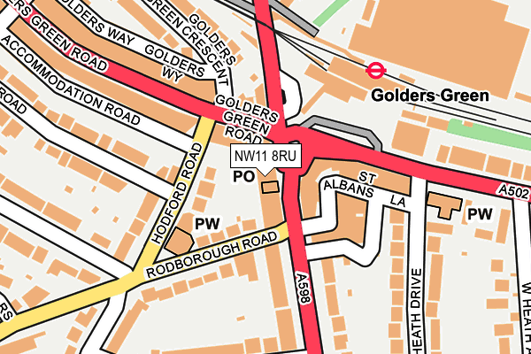
NW11 8RU is located in the Childs Hill electoral ward, within the London borough of Barnet and the English Parliamentary constituency of Finchley and Golders Green. The Sub Integrated Care Board (ICB) Location is NHS North Central London ICB - 93C and the police force is Metropolitan Police. This postcode has been in use since January 1980.


GetTheData
Source: OS OpenMap – Local (Ordnance Survey)
Source: OS VectorMap District (Ordnance Survey)
Licence: Open Government Licence (requires attribution)
| Easting | 525139 |
| Northing | 187372 |
| Latitude | 51.571339 |
| Longitude | -0.195735 |
GetTheData
Source: Open Postcode Geo
Licence: Open Government Licence
| Country | England |
| Postcode District | NW11 |
➜ See where NW11 is on a map ➜ Where is London? | |
GetTheData
Source: Land Registry Price Paid Data
Licence: Open Government Licence
Elevation or altitude of NW11 8RU as distance above sea level:
| Metres | Feet | |
|---|---|---|
| Elevation | 70m | 230ft |
Elevation is measured from the approximate centre of the postcode, to the nearest point on an OS contour line from OS Terrain 50, which has contour spacing of ten vertical metres.
➜ How high above sea level am I? Find the elevation of your current position using your device's GPS.
GetTheData
Source: Open Postcode Elevation
Licence: Open Government Licence
| Ward | Childs Hill |
| Constituency | Finchley And Golders Green |
GetTheData
Source: ONS Postcode Database
Licence: Open Government Licence
| Golders Green Finchley Road (Finchley Road) | Golders Green | 34m |
| Golders Green Finchley Road (Finchley Road) | Golders Green | 56m |
| Finchley Road (Nw11) (Golders Green Road) | Golders Green | 68m |
| Hodford Road | Child's Hill | 82m |
| Golders Green (Golders Green Bus Station) | Golders Green | 86m |
| Golders Green Underground Station | Golders Green | 156m |
| Brent Cross Underground Station | Brent Cross | 1,373m |
| Cricklewood Station | 1.9km |
| Finchley Road & Frognal Station | 2.5km |
| West Hampstead Thameslink Station | 2.6km |
GetTheData
Source: NaPTAN
Licence: Open Government Licence
GetTheData
Source: ONS Postcode Database
Licence: Open Government Licence


➜ Get more ratings from the Food Standards Agency
GetTheData
Source: Food Standards Agency
Licence: FSA terms & conditions
| Last Collection | |||
|---|---|---|---|
| Location | Mon-Fri | Sat | Distance |
| Golders Green Post Office | 18:30 | 12:00 | 22m |
| North End Road | 17:30 | 12:00 | 160m |
| 60 Golders Green Road | 17:30 | 12:00 | 248m |
GetTheData
Source: Dracos
Licence: Creative Commons Attribution-ShareAlike
The below table lists the International Territorial Level (ITL) codes (formerly Nomenclature of Territorial Units for Statistics (NUTS) codes) and Local Administrative Units (LAU) codes for NW11 8RU:
| ITL 1 Code | Name |
|---|---|
| TLI | London |
| ITL 2 Code | Name |
| TLI7 | Outer London - West and North West |
| ITL 3 Code | Name |
| TLI71 | Barnet |
| LAU 1 Code | Name |
| E09000003 | Barnet |
GetTheData
Source: ONS Postcode Directory
Licence: Open Government Licence
The below table lists the Census Output Area (OA), Lower Layer Super Output Area (LSOA), and Middle Layer Super Output Area (MSOA) for NW11 8RU:
| Code | Name | |
|---|---|---|
| OA | E00000702 | |
| LSOA | E01000146 | Barnet 038D |
| MSOA | E02000061 | Barnet 038 |
GetTheData
Source: ONS Postcode Directory
Licence: Open Government Licence
| NW11 8RR | Finchley Road | 20m |
| NW11 8DY | Golders Green Road | 53m |
| NW11 7RR | Finchley Road | 53m |
| NW11 8EG | Hodford Road | 64m |
| NW11 8RY | Rodborough Road | 73m |
| NW11 7PH | North End Road | 89m |
| NW11 8LX | Finchley Road | 102m |
| NW11 7PT | North End Road | 137m |
| NW11 8EE | Golders Green Road | 139m |
| NW11 8SA | Rodborough Road | 141m |
GetTheData
Source: Open Postcode Geo; Land Registry Price Paid Data
Licence: Open Government Licence