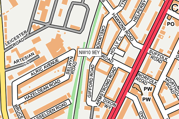
NW10 9EY is located in the Roundwood electoral ward, within the London borough of Brent and the English Parliamentary constituency of Brent Central. The Sub Integrated Care Board (ICB) Location is NHS North West London ICB - W2U3Z and the police force is Metropolitan Police. This postcode has been in use since January 1980.


GetTheData
Source: OS OpenMap – Local (Ordnance Survey)
Source: OS VectorMap District (Ordnance Survey)
Licence: Open Government Licence (requires attribution)
| Easting | 521074 |
| Northing | 184285 |
| Latitude | 51.544482 |
| Longitude | -0.255422 |
GetTheData
Source: Open Postcode Geo
Licence: Open Government Licence
| Country | England |
| Postcode District | NW10 |
➜ See where NW10 is on a map ➜ Where is London? | |
GetTheData
Source: Land Registry Price Paid Data
Licence: Open Government Licence
Elevation or altitude of NW10 9EY as distance above sea level:
| Metres | Feet | |
|---|---|---|
| Elevation | 40m | 131ft |
Elevation is measured from the approximate centre of the postcode, to the nearest point on an OS contour line from OS Terrain 50, which has contour spacing of ten vertical metres.
➜ How high above sea level am I? Find the elevation of your current position using your device's GPS.
GetTheData
Source: Open Postcode Elevation
Licence: Open Government Licence
| Ward | Roundwood |
| Constituency | Brent Central |
GetTheData
Source: ONS Postcode Database
Licence: Open Government Licence
| Denbigh Close (Church Road) | Stonebridge | 188m |
| Denbigh Close (Church Road) | Stonebridge | 208m |
| Curzon Crescent Willesden (Church Road) | Church End | 242m |
| Curzon Crescent Willesden (Church Road) | Church End | 265m |
| Gloucester Close (Brentfield Road) | Stonebridge | 302m |
| Harlesden Underground Station | Harlesden | 925m |
| Neasden Underground Station | Neasden | 1,126m |
| Dollis Hill Underground Station | Dudden Hill | 1,406m |
| Stonebridge Park Underground Station | Stonebridge Park | 1,421m |
| Willesden Junction Underground Station | Willesden Junction | 1,564m |
| Harlesden Station | 0.9km |
| Stonebridge Park Station | 1.4km |
| Willesden Junction Station | 1.5km |
GetTheData
Source: NaPTAN
Licence: Open Government Licence
GetTheData
Source: ONS Postcode Database
Licence: Open Government Licence


➜ Get more ratings from the Food Standards Agency
GetTheData
Source: Food Standards Agency
Licence: FSA terms & conditions
| Last Collection | |||
|---|---|---|---|
| Location | Mon-Fri | Sat | Distance |
| 50 Church Road | 17:30 | 12:00 | 173m |
| Craven Park Road | 17:30 | 12:00 | 282m |
| 38 Bruce Road | 17:30 | 12:00 | 289m |
GetTheData
Source: Dracos
Licence: Creative Commons Attribution-ShareAlike
The below table lists the International Territorial Level (ITL) codes (formerly Nomenclature of Territorial Units for Statistics (NUTS) codes) and Local Administrative Units (LAU) codes for NW10 9EY:
| ITL 1 Code | Name |
|---|---|
| TLI | London |
| ITL 2 Code | Name |
| TLI7 | Outer London - West and North West |
| ITL 3 Code | Name |
| TLI72 | Brent |
| LAU 1 Code | Name |
| E09000005 | Brent |
GetTheData
Source: ONS Postcode Directory
Licence: Open Government Licence
The below table lists the Census Output Area (OA), Lower Layer Super Output Area (LSOA), and Middle Layer Super Output Area (MSOA) for NW10 9EY:
| Code | Name | |
|---|---|---|
| OA | E00002562 | |
| LSOA | E01000528 | Brent 025F |
| MSOA | E02000117 | Brent 025 |
GetTheData
Source: ONS Postcode Directory
Licence: Open Government Licence
| NW10 8QY | Selwyn Road | 55m |
| NW10 9DJ | Creukhorne Road | 66m |
| NW10 8QX | Selwyn Road | 90m |
| NW10 9DL | Paulet Way | 93m |
| NW10 9ED | Gifford Road | 95m |
| NW10 9EF | Armstrong Road | 115m |
| NW10 9EG | Church Road | 131m |
| NW10 9DF | Hawkins Road | 144m |
| NW10 8RB | Alric Avenue | 165m |
| NW10 8RA | Alric Avenue | 166m |
GetTheData
Source: Open Postcode Geo; Land Registry Price Paid Data
Licence: Open Government Licence