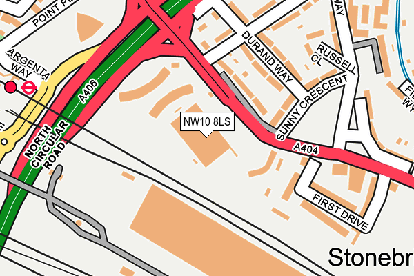
NW10 8LS is located in the Stonebridge electoral ward, within the London borough of Brent and the English Parliamentary constituency of Brent Central. The Sub Integrated Care Board (ICB) Location is NHS North West London ICB - W2U3Z and the police force is Metropolitan Police. This postcode has been in use since June 2018.


GetTheData
Source: OS OpenMap – Local (Ordnance Survey)
Source: OS VectorMap District (Ordnance Survey)
Licence: Open Government Licence (requires attribution)
| Easting | 519971 |
| Northing | 184092 |
| Latitude | 51.542985 |
| Longitude | -0.271362 |
GetTheData
Source: Open Postcode Geo
Licence: Open Government Licence
| Country | England |
| Postcode District | NW10 |
➜ See where NW10 is on a map ➜ Where is London? | |
GetTheData
Source: Land Registry Price Paid Data
Licence: Open Government Licence
Elevation or altitude of NW10 8LS as distance above sea level:
| Metres | Feet | |
|---|---|---|
| Elevation | 30m | 98ft |
Elevation is measured from the approximate centre of the postcode, to the nearest point on an OS contour line from OS Terrain 50, which has contour spacing of ten vertical metres.
➜ How high above sea level am I? Find the elevation of your current position using your device's GPS.
GetTheData
Source: Open Postcode Elevation
Licence: Open Government Licence
| Ward | Stonebridge |
| Constituency | Brent Central |
GetTheData
Source: ONS Postcode Database
Licence: Open Government Licence
| North Circular Rd Brentfield (Brentfield) | Stonebridge Park | 93m |
| North Circular Rd Brentfield (Brentfield) | Stonebridge Park | 109m |
| Sunny Crescent (Brentfield) | Stonebridge | 152m |
| Harrow Road North Circular Rd | Stonebridge Park | 227m |
| Stonebridge Park Station (North Circular Road) | Stonebridge | 247m |
| Stonebridge Park Underground Station | Stonebridge Park | 331m |
| Harlesden Underground Station | Harlesden | 1,195m |
| Neasden Underground Station | Neasden | 1,932m |
| Hanger Lane Underground Station | Hanger Lane | 2,053m |
| Stonebridge Park Station | 0.3km |
| Harlesden Station | 1.2km |
| Wembley Stadium Station | 1.6km |
GetTheData
Source: NaPTAN
Licence: Open Government Licence
GetTheData
Source: ONS Postcode Database
Licence: Open Government Licence


➜ Get more ratings from the Food Standards Agency
GetTheData
Source: Food Standards Agency
Licence: FSA terms & conditions
| Last Collection | |||
|---|---|---|---|
| Location | Mon-Fri | Sat | Distance |
| Prdc Stonebridge Park | 17:30 | 12:00 | 221m |
| Hillside/Barry Road | 17:30 | 12:00 | 491m |
| Heather Park Drive | 17:30 | 12:30 | 495m |
GetTheData
Source: Dracos
Licence: Creative Commons Attribution-ShareAlike
| Risk of NW10 8LS flooding from rivers and sea | High |
| ➜ NW10 8LS flood map | |
GetTheData
Source: Open Flood Risk by Postcode
Licence: Open Government Licence
The below table lists the International Territorial Level (ITL) codes (formerly Nomenclature of Territorial Units for Statistics (NUTS) codes) and Local Administrative Units (LAU) codes for NW10 8LS:
| ITL 1 Code | Name |
|---|---|
| TLI | London |
| ITL 2 Code | Name |
| TLI7 | Outer London - West and North West |
| ITL 3 Code | Name |
| TLI72 | Brent |
| LAU 1 Code | Name |
| E09000005 | Brent |
GetTheData
Source: ONS Postcode Directory
Licence: Open Government Licence
The below table lists the Census Output Area (OA), Lower Layer Super Output Area (LSOA), and Middle Layer Super Output Area (MSOA) for NW10 8LS:
| Code | Name | |
|---|---|---|
| OA | E00002928 | |
| LSOA | E01033456 | Brent 027F |
| MSOA | E02000119 | Brent 027 |
GetTheData
Source: ONS Postcode Directory
Licence: Open Government Licence
| NW10 0RH | Brentfield | 106m |
| NW10 0QY | Durand Way | 136m |
| NW10 0RU | Conduit Way | 164m |
| NW10 8LQ | First Drive | 178m |
| NW10 0RB | Sunny Crescent | 191m |
| NW10 0QX | Durand Way | 201m |
| NW10 0RD | Russell Close | 203m |
| NW10 8LG | First Drive | 209m |
| NW10 0RY | Conduit Way | 232m |
| NW10 0TA | Foxholt Gardens | 236m |
GetTheData
Source: Open Postcode Geo; Land Registry Price Paid Data
Licence: Open Government Licence