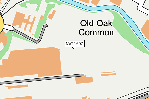
NW10 6DZ is located in the College Park & Old Oak electoral ward, within the London borough of Hammersmith and Fulham and the English Parliamentary constituency of Hammersmith. The Sub Integrated Care Board (ICB) Location is NHS North West London ICB - W2U3Z and the police force is Metropolitan Police. This postcode has been in use since December 1996.


GetTheData
Source: OS OpenMap – Local (Ordnance Survey)
Source: OS VectorMap District (Ordnance Survey)
Licence: Open Government Licence (requires attribution)
| Easting | 521888 |
| Northing | 182002 |
| Latitude | 51.523791 |
| Longitude | -0.244455 |
GetTheData
Source: Open Postcode Geo
Licence: Open Government Licence
| Country | England |
| Postcode District | NW10 |
➜ See where NW10 is on a map ➜ Where is London? | |
GetTheData
Source: Land Registry Price Paid Data
Licence: Open Government Licence
Elevation or altitude of NW10 6DZ as distance above sea level:
| Metres | Feet | |
|---|---|---|
| Elevation | 30m | 98ft |
Elevation is measured from the approximate centre of the postcode, to the nearest point on an OS contour line from OS Terrain 50, which has contour spacing of ten vertical metres.
➜ How high above sea level am I? Find the elevation of your current position using your device's GPS.
GetTheData
Source: Open Postcode Elevation
Licence: Open Government Licence
| Ward | College Park & Old Oak |
| Constituency | Hammersmith |
GetTheData
Source: ONS Postcode Database
Licence: Open Government Licence
| Wells House Road | Old Oak Common | 542m |
| Wells House Road | Old Oak Common | 553m |
| Old Oak Common Railway Depot | Old Oak Common | 558m |
| Old Oak Common Railway Depot | Old Oak Common | 564m |
| Brunel Road | North Acton | 622m |
| East Acton Underground Station | East Acton | 821m |
| Willesden Junction Underground Station | Willesden Junction | 942m |
| North Acton Underground Station | North Acton | 1,060m |
| Kensal Green Underground Station | Kensal Green | 1,545m |
| Harlesden Underground Station | Harlesden | 1,675m |
| Willesden Junction Station | 1km |
| Kensal Green Station | 1.5km |
| Harlesden Station | 1.7km |
GetTheData
Source: NaPTAN
Licence: Open Government Licence
GetTheData
Source: ONS Postcode Database
Licence: Open Government Licence


➜ Get more ratings from the Food Standards Agency
GetTheData
Source: Food Standards Agency
Licence: FSA terms & conditions
| Last Collection | |||
|---|---|---|---|
| Location | Mon-Fri | Sat | Distance |
| Hythe Road | 18:30 | 12:00 | 525m |
| Old Oak Common Lane | 18:30 | 12:00 | 552m |
| Wells House Road | 17:30 | 12:00 | 586m |
GetTheData
Source: Dracos
Licence: Creative Commons Attribution-ShareAlike
The below table lists the International Territorial Level (ITL) codes (formerly Nomenclature of Territorial Units for Statistics (NUTS) codes) and Local Administrative Units (LAU) codes for NW10 6DZ:
| ITL 1 Code | Name |
|---|---|
| TLI | London |
| ITL 2 Code | Name |
| TLI3 | Inner London - West |
| ITL 3 Code | Name |
| TLI33 | Kensington & Chelsea and Hammersmith & Fulham |
| LAU 1 Code | Name |
| E09000013 | Hammersmith and Fulham |
GetTheData
Source: ONS Postcode Directory
Licence: Open Government Licence
The below table lists the Census Output Area (OA), Lower Layer Super Output Area (LSOA), and Middle Layer Super Output Area (MSOA) for NW10 6DZ:
| Code | Name | |
|---|---|---|
| OA | E00167293 | |
| LSOA | E01001876 | Hammersmith and Fulham 001C |
| MSOA | E02000372 | Hammersmith and Fulham 001 |
GetTheData
Source: ONS Postcode Directory
Licence: Open Government Licence
| W12 0AJ | Braybrook Street | 494m |
| W12 0AS | Mellitus Street | 506m |
| W12 0AX | Osmund Street | 513m |
| NW10 6RT | Hythe Road | 527m |
| W12 0AL | Braybrook Street | 536m |
| NW10 6RJ | Hythe Road | 537m |
| NW10 6ED | Wells House Road | 567m |
| W12 0AU | Mellitus Street | 573m |
| NW10 6UG | Enterprise Way | 578m |
| W12 0BX | Erconwald Street | 589m |
GetTheData
Source: Open Postcode Geo; Land Registry Price Paid Data
Licence: Open Government Licence