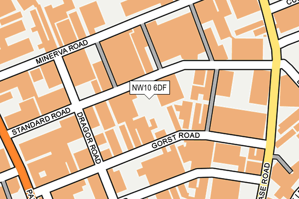
NW10 6DF is located in the North Acton electoral ward, within the London borough of Ealing and the English Parliamentary constituency of Ealing Central and Acton. The Sub Integrated Care Board (ICB) Location is NHS North West London ICB - W2U3Z and the police force is Metropolitan Police. This postcode has been in use since January 1983.


GetTheData
Source: OS OpenMap – Local (Ordnance Survey)
Source: OS VectorMap District (Ordnance Survey)
Licence: Open Government Licence (requires attribution)
| Easting | 520590 |
| Northing | 182430 |
| Latitude | 51.527916 |
| Longitude | -0.263010 |
GetTheData
Source: Open Postcode Geo
Licence: Open Government Licence
| Country | England |
| Postcode District | NW10 |
➜ See where NW10 is on a map ➜ Where is Acton? | |
GetTheData
Source: Land Registry Price Paid Data
Licence: Open Government Licence
Elevation or altitude of NW10 6DF as distance above sea level:
| Metres | Feet | |
|---|---|---|
| Elevation | 40m | 131ft |
Elevation is measured from the approximate centre of the postcode, to the nearest point on an OS contour line from OS Terrain 50, which has contour spacing of ten vertical metres.
➜ How high above sea level am I? Find the elevation of your current position using your device's GPS.
GetTheData
Source: Open Postcode Elevation
Licence: Open Government Licence
| Ward | North Acton |
| Constituency | Ealing Central And Acton |
GetTheData
Source: ONS Postcode Database
Licence: Open Government Licence
| Standard Road | North Acton | 55m |
| Minerva Road | North Acton | 161m |
| Bashley Road (Chase Road) | North Acton | 245m |
| Sunbeam Road (Chase Road) | North Acton | 277m |
| Cunard Road (Chase Road) | North Acton | 284m |
| North Acton Underground Station | North Acton | 539m |
| Harlesden Underground Station | Harlesden | 1,000m |
| Willesden Junction Underground Station | Willesden Junction | 1,388m |
| Park Royal Underground Station | Park Royal | 1,481m |
| West Acton Underground Station | West Acton | 1,664m |
| Harlesden Station | 1km |
| Acton Main Line Station | 1.2km |
| Willesden Junction Station | 1.4km |
GetTheData
Source: NaPTAN
Licence: Open Government Licence
GetTheData
Source: ONS Postcode Database
Licence: Open Government Licence


➜ Get more ratings from the Food Standards Agency
GetTheData
Source: Food Standards Agency
Licence: FSA terms & conditions
| Last Collection | |||
|---|---|---|---|
| Location | Mon-Fri | Sat | Distance |
| Chase Road | 17:30 | 12:00 | 261m |
| Chase Road | 17:30 | 12:00 | 298m |
| 41 Park Royal Road | 17:30 | 12:00 | 300m |
GetTheData
Source: Dracos
Licence: Creative Commons Attribution-ShareAlike
The below table lists the International Territorial Level (ITL) codes (formerly Nomenclature of Territorial Units for Statistics (NUTS) codes) and Local Administrative Units (LAU) codes for NW10 6DF:
| ITL 1 Code | Name |
|---|---|
| TLI | London |
| ITL 2 Code | Name |
| TLI7 | Outer London - West and North West |
| ITL 3 Code | Name |
| TLI73 | Ealing |
| LAU 1 Code | Name |
| E09000009 | Ealing |
GetTheData
Source: ONS Postcode Directory
Licence: Open Government Licence
The below table lists the Census Output Area (OA), Lower Layer Super Output Area (LSOA), and Middle Layer Super Output Area (MSOA) for NW10 6DF:
| Code | Name | |
|---|---|---|
| OA | E00006193 | |
| LSOA | E01001246 | Ealing 015D |
| MSOA | E02000252 | Ealing 015 |
GetTheData
Source: ONS Postcode Directory
Licence: Open Government Licence
| NW10 6LE | Gorst Road | 59m |
| NW10 6EU | Standard Road | 106m |
| NW10 6LA | Gorst Road | 132m |
| NW10 6HA | Standard Road | 169m |
| NW10 6HJ | Minerva Road | 192m |
| NW10 6LD | Gorst Road | 206m |
| NW10 6JP | Sunbeam Road | 228m |
| NW10 6QN | Chase Road | 240m |
| NW10 6LS | Gorst Road | 254m |
| NW10 7PD | Acton Lane | 263m |
GetTheData
Source: Open Postcode Geo; Land Registry Price Paid Data
Licence: Open Government Licence