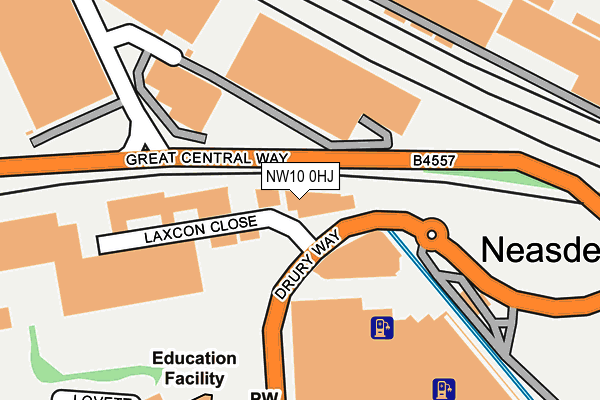
NW10 0HJ is located in the Stonebridge electoral ward, within the London borough of Brent and the English Parliamentary constituency of Brent Central. The Sub Integrated Care Board (ICB) Location is NHS North West London ICB - W2U3Z and the police force is Metropolitan Police. This postcode has been in use since December 2012.


GetTheData
Source: OS OpenMap – Local (Ordnance Survey)
Source: OS VectorMap District (Ordnance Survey)
Licence: Open Government Licence (requires attribution)
| Easting | 520640 |
| Northing | 185495 |
| Latitude | 51.555449 |
| Longitude | -0.261263 |
GetTheData
Source: Open Postcode Geo
Licence: Open Government Licence
| Country | England |
| Postcode District | NW10 |
➜ See where NW10 is on a map ➜ Where is London? | |
GetTheData
Source: Land Registry Price Paid Data
Licence: Open Government Licence
Elevation or altitude of NW10 0HJ as distance above sea level:
| Metres | Feet | |
|---|---|---|
| Elevation | 30m | 98ft |
Elevation is measured from the approximate centre of the postcode, to the nearest point on an OS contour line from OS Terrain 50, which has contour spacing of ten vertical metres.
➜ How high above sea level am I? Find the elevation of your current position using your device's GPS.
GetTheData
Source: Open Postcode Elevation
Licence: Open Government Licence
| Ward | Stonebridge |
| Constituency | Brent Central |
GetTheData
Source: ONS Postcode Database
Licence: Open Government Licence
| Ikea Brent Park Panther Drive (Drury Way) | Neasden | 153m |
| Hannah Close (Great Central Way) | Neasden | 211m |
| Ikea Brent Park (Drury Way) | Church End | 225m |
| Ikea Brent Park Drury Way (Drury Way) | Church End | 244m |
| Hannah Close (Great Central Way) | Neasden | 297m |
| Neasden Underground Station | Neasden | 809m |
| Wembley Park Underground Station | Wembley Park | 1,517m |
| Stonebridge Park Underground Station | Stonebridge Park | 1,632m |
| Stonebridge Park Station | 1.6km |
| Wembley Stadium Station | 1.7km |
| Harlesden Station | 2.1km |
GetTheData
Source: NaPTAN
Licence: Open Government Licence
GetTheData
Source: ONS Postcode Database
Licence: Open Government Licence


➜ Get more ratings from the Food Standards Agency
GetTheData
Source: Food Standards Agency
Licence: FSA terms & conditions
| Last Collection | |||
|---|---|---|---|
| Location | Mon-Fri | Sat | Distance |
| Tesco Post Office | 18:30 | 12:00 | 399m |
| Woodheys Road | 17:30 | 12:00 | 458m |
| Brentfield Road | 17:30 | 12:00 | 526m |
GetTheData
Source: Dracos
Licence: Creative Commons Attribution-ShareAlike
The below table lists the International Territorial Level (ITL) codes (formerly Nomenclature of Territorial Units for Statistics (NUTS) codes) and Local Administrative Units (LAU) codes for NW10 0HJ:
| ITL 1 Code | Name |
|---|---|
| TLI | London |
| ITL 2 Code | Name |
| TLI7 | Outer London - West and North West |
| ITL 3 Code | Name |
| TLI72 | Brent |
| LAU 1 Code | Name |
| E09000005 | Brent |
GetTheData
Source: ONS Postcode Directory
Licence: Open Government Licence
The below table lists the Census Output Area (OA), Lower Layer Super Output Area (LSOA), and Middle Layer Super Output Area (MSOA) for NW10 0HJ:
| Code | Name | |
|---|---|---|
| OA | E00002900 | |
| LSOA | E01000601 | Brent 021B |
| MSOA | E02000113 | Brent 021 |
GetTheData
Source: ONS Postcode Directory
Licence: Open Government Licence
| NW10 0TG | Drury Way Industrial Estate | 112m |
| NW10 0UH | Hardie Close | 279m |
| NW10 0UJ | Lovett Way | 291m |
| NW10 0UL | Lovett Way | 303m |
| NW10 0UG | Bentham Walk | 316m |
| NW10 0UN | Lovett Way | 331m |
| NW10 0UQ | Bentham Walk | 363m |
| NW10 0NU | St Raphaels Way | 386m |
| NW10 0JT | North Circular Road | 419m |
| NW10 0JR | North Circular Road | 430m |
GetTheData
Source: Open Postcode Geo; Land Registry Price Paid Data
Licence: Open Government Licence