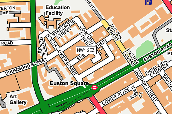
NW1 2EZ is located in the Regent's Park electoral ward, within the London borough of Camden and the English Parliamentary constituency of Holborn and St Pancras. The Sub Integrated Care Board (ICB) Location is NHS North Central London ICB - 93C and the police force is Metropolitan Police. This postcode has been in use since January 1991.


GetTheData
Source: OS OpenMap – Local (Ordnance Survey)
Source: OS VectorMap District (Ordnance Survey)
Licence: Open Government Licence (requires attribution)
| Easting | 529404 |
| Northing | 182507 |
| Latitude | 51.526657 |
| Longitude | -0.136017 |
GetTheData
Source: Open Postcode Geo
Licence: Open Government Licence
| Country | England |
| Postcode District | NW1 |
➜ See where NW1 is on a map ➜ Where is London? | |
GetTheData
Source: Land Registry Price Paid Data
Licence: Open Government Licence
Elevation or altitude of NW1 2EZ as distance above sea level:
| Metres | Feet | |
|---|---|---|
| Elevation | 20m | 66ft |
Elevation is measured from the approximate centre of the postcode, to the nearest point on an OS contour line from OS Terrain 50, which has contour spacing of ten vertical metres.
➜ How high above sea level am I? Find the elevation of your current position using your device's GPS.
GetTheData
Source: Open Postcode Elevation
Licence: Open Government Licence
| Ward | Regent's Park |
| Constituency | Holborn And St Pancras |
GetTheData
Source: ONS Postcode Database
Licence: Open Government Licence
| Euston Square (Euston Road) | Euston Square | 117m |
| Euston Station (Melton Street) | Euston | 129m |
| Euston Square | Euston Square | 131m |
| Warren Street | Warren Street | 160m |
| University College Hosp Warren Street Stn | Warren Street | 167m |
| Euston Square Underground Station | Euston Square | 118m |
| Euston Underground Station | Euston | 215m |
| Warren Street Underground Station | Warren Street | 248m |
| Great Portland Street Underground Station | Great Portland Street | 652m |
| Goodge Street Underground Station | Goodge Street | 684m |
| London Euston Station | 0.2km |
| London St Pancras International LL Station | 0.9km |
| London St Pancras International Station | 0.9km |
GetTheData
Source: NaPTAN
Licence: Open Government Licence
| Percentage of properties with Next Generation Access | 100.0% |
| Percentage of properties with Superfast Broadband | 100.0% |
| Percentage of properties with Ultrafast Broadband | 100.0% |
| Percentage of properties with Full Fibre Broadband | 0.0% |
Superfast Broadband is between 30Mbps and 300Mbps
Ultrafast Broadband is > 300Mbps
| Percentage of properties unable to receive 2Mbps | 0.0% |
| Percentage of properties unable to receive 5Mbps | 0.0% |
| Percentage of properties unable to receive 10Mbps | 0.0% |
| Percentage of properties unable to receive 30Mbps | 0.0% |
GetTheData
Source: Ofcom
Licence: Ofcom Terms of Use (requires attribution)
GetTheData
Source: ONS Postcode Database
Licence: Open Government Licence


➜ Get more ratings from the Food Standards Agency
GetTheData
Source: Food Standards Agency
Licence: FSA terms & conditions
| Last Collection | |||
|---|---|---|---|
| Location | Mon-Fri | Sat | Distance |
| Drummond Street | 19:00 | 13:00 | 95m |
| Euston Station | 19:00 | 13:00 | 276m |
| Hampstead Road | 19:00 | 13:00 | 286m |
GetTheData
Source: Dracos
Licence: Creative Commons Attribution-ShareAlike
The below table lists the International Territorial Level (ITL) codes (formerly Nomenclature of Territorial Units for Statistics (NUTS) codes) and Local Administrative Units (LAU) codes for NW1 2EZ:
| ITL 1 Code | Name |
|---|---|
| TLI | London |
| ITL 2 Code | Name |
| TLI3 | Inner London - West |
| ITL 3 Code | Name |
| TLI31 | Camden and City of London |
| LAU 1 Code | Name |
| E09000007 | Camden |
GetTheData
Source: ONS Postcode Directory
Licence: Open Government Licence
The below table lists the Census Output Area (OA), Lower Layer Super Output Area (LSOA), and Middle Layer Super Output Area (MSOA) for NW1 2EZ:
| Code | Name | |
|---|---|---|
| OA | E00004694 | |
| LSOA | E01000945 | Camden 023B |
| MSOA | E02000188 | Camden 023 |
GetTheData
Source: ONS Postcode Directory
Licence: Open Government Licence
| NW1 2HA | Euston Street | 30m |
| NW1 2EX | Euston Street | 40m |
| NW1 2ND | North Gower Street | 50m |
| NW1 2HL | Drummond Street | 64m |
| NW1 2NB | North Gower Street | 67m |
| NW1 2HH | Cobourg Street | 67m |
| NW1 2ES | Euston Street | 75m |
| NW1 2HN | Drummond Street | 84m |
| NW1 2NJ | North Gower Street | 87m |
| NW1 2HB | Cobourg Street | 89m |
GetTheData
Source: Open Postcode Geo; Land Registry Price Paid Data
Licence: Open Government Licence