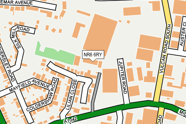
NR6 6RY is located in the Hellesdon South East electoral ward, within the local authority district of Broadland and the English Parliamentary constituency of Norwich North. The Sub Integrated Care Board (ICB) Location is NHS Norfolk and Waveney ICB - 26A and the police force is Norfolk. This postcode has been in use since January 1980.


GetTheData
Source: OS OpenMap – Local (Ordnance Survey)
Source: OS VectorMap District (Ordnance Survey)
Licence: Open Government Licence (requires attribution)
| Easting | 622013 |
| Northing | 311853 |
| Latitude | 52.658942 |
| Longitude | 1.281332 |
GetTheData
Source: Open Postcode Geo
Licence: Open Government Licence
| Country | England |
| Postcode District | NR6 |
➜ See where NR6 is on a map ➜ Where is Norwich? | |
GetTheData
Source: Land Registry Price Paid Data
Licence: Open Government Licence
Elevation or altitude of NR6 6RY as distance above sea level:
| Metres | Feet | |
|---|---|---|
| Elevation | 30m | 98ft |
Elevation is measured from the approximate centre of the postcode, to the nearest point on an OS contour line from OS Terrain 50, which has contour spacing of ten vertical metres.
➜ How high above sea level am I? Find the elevation of your current position using your device's GPS.
GetTheData
Source: Open Postcode Elevation
Licence: Open Government Licence
| Ward | Hellesdon South East |
| Constituency | Norwich North |
GetTheData
Source: ONS Postcode Database
Licence: Open Government Licence
| Mason Road (Mile Cross Lane) | Norwich | 170m |
| Kfc (Vulcan Road South) | Norwich | 219m |
| Lilian Close (Mile Cross Lane) | Norwich | 226m |
| Kfc (Vulcan Road South) | Norwich | 236m |
| Concorde Road (Vulcan Road South) | Norwich | 245m |
| Norwich Station | 3.9km |
GetTheData
Source: NaPTAN
Licence: Open Government Licence
GetTheData
Source: ONS Postcode Database
Licence: Open Government Licence


➜ Get more ratings from the Food Standards Agency
GetTheData
Source: Food Standards Agency
Licence: FSA terms & conditions
| Last Collection | |||
|---|---|---|---|
| Location | Mon-Fri | Sat | Distance |
| Vulcan Road | 18:30 | 11:00 | 270m |
| Boundary Road | 17:30 | 11:00 | 404m |
| Cromer Road | 18:30 | 11:00 | 549m |
GetTheData
Source: Dracos
Licence: Creative Commons Attribution-ShareAlike
The below table lists the International Territorial Level (ITL) codes (formerly Nomenclature of Territorial Units for Statistics (NUTS) codes) and Local Administrative Units (LAU) codes for NR6 6RY:
| ITL 1 Code | Name |
|---|---|
| TLH | East |
| ITL 2 Code | Name |
| TLH1 | East Anglia |
| ITL 3 Code | Name |
| TLH15 | Norwich and East Norfolk |
| LAU 1 Code | Name |
| E07000144 | Broadland |
GetTheData
Source: ONS Postcode Directory
Licence: Open Government Licence
The below table lists the Census Output Area (OA), Lower Layer Super Output Area (LSOA), and Middle Layer Super Output Area (MSOA) for NR6 6RY:
| Code | Name | |
|---|---|---|
| OA | E00134817 | |
| LSOA | E01026530 | Broadland 011A |
| MSOA | E02005530 | Broadland 011 |
GetTheData
Source: ONS Postcode Directory
Licence: Open Government Licence
| NR6 6RZ | Lilian Close | 105m |
| NR6 6SU | Jupiter Road | 128m |
| NR6 6BA | Vulcan Road South | 167m |
| NR6 6RL | Mile Cross Lane | 189m |
| NR6 6SQ | Coldershaw Road | 192m |
| NR6 6SN | Mayfield Avenue | 201m |
| NR6 6SE | Mile Cross Lane | 248m |
| NR6 6TB | Waldemar Avenue | 272m |
| NR6 6SG | Eversley Road | 277m |
| NR6 6RA | Mile Cross Lane | 282m |
GetTheData
Source: Open Postcode Geo; Land Registry Price Paid Data
Licence: Open Government Licence