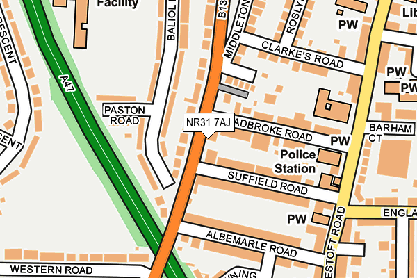
NR31 7AJ lies on Middleton Road in Gorleston, Great Yarmouth. NR31 7AJ is located in the St Andrews electoral ward, within the local authority district of Great Yarmouth and the English Parliamentary constituency of Great Yarmouth. The Sub Integrated Care Board (ICB) Location is NHS Norfolk and Waveney ICB - 26A and the police force is Norfolk. This postcode has been in use since January 1980.


GetTheData
Source: OS OpenMap – Local (Ordnance Survey)
Source: OS VectorMap District (Ordnance Survey)
Licence: Open Government Licence (requires attribution)
| Easting | 652359 |
| Northing | 304021 |
| Latitude | 52.575425 |
| Longitude | 1.723093 |
GetTheData
Source: Open Postcode Geo
Licence: Open Government Licence
| Street | Middleton Road |
| Locality | Gorleston |
| Town/City | Great Yarmouth |
| Country | England |
| Postcode District | NR31 |
➜ See where NR31 is on a map ➜ Where is Gorleston-on-Sea? | |
GetTheData
Source: Land Registry Price Paid Data
Licence: Open Government Licence
Elevation or altitude of NR31 7AJ as distance above sea level:
| Metres | Feet | |
|---|---|---|
| Elevation | 10m | 33ft |
Elevation is measured from the approximate centre of the postcode, to the nearest point on an OS contour line from OS Terrain 50, which has contour spacing of ten vertical metres.
➜ How high above sea level am I? Find the elevation of your current position using your device's GPS.
GetTheData
Source: Open Postcode Elevation
Licence: Open Government Licence
| Ward | St Andrews |
| Constituency | Great Yarmouth |
GetTheData
Source: ONS Postcode Database
Licence: Open Government Licence
| Suffield Road (Middleton Road) | Gorleston | 28m |
| Suffield Road (Middleton Road) | Gorleston | 92m |
| Police Station (Lowestoft Road) | Gorleston | 202m |
| St Catherines Way (Middleton Road) | Gorleston | 247m |
| Keppel Rd (Lowestoft Road) | Gorleston | 266m |
| Great Yarmouth Station | 4.1km |
GetTheData
Source: NaPTAN
Licence: Open Government Licence
GetTheData
Source: ONS Postcode Database
Licence: Open Government Licence


➜ Get more ratings from the Food Standards Agency
GetTheData
Source: Food Standards Agency
Licence: FSA terms & conditions
| Last Collection | |||
|---|---|---|---|
| Location | Mon-Fri | Sat | Distance |
| Lowestoft Road | 17:30 | 12:15 | 198m |
| 118-120 High Street P.o. | 17:30 | 12:00 | 460m |
| Bells Road | 17:30 | 12:00 | 466m |
GetTheData
Source: Dracos
Licence: Creative Commons Attribution-ShareAlike
The below table lists the International Territorial Level (ITL) codes (formerly Nomenclature of Territorial Units for Statistics (NUTS) codes) and Local Administrative Units (LAU) codes for NR31 7AJ:
| ITL 1 Code | Name |
|---|---|
| TLH | East |
| ITL 2 Code | Name |
| TLH1 | East Anglia |
| ITL 3 Code | Name |
| TLH15 | Norwich and East Norfolk |
| LAU 1 Code | Name |
| E07000145 | Great Yarmouth |
GetTheData
Source: ONS Postcode Directory
Licence: Open Government Licence
The below table lists the Census Output Area (OA), Lower Layer Super Output Area (LSOA), and Middle Layer Super Output Area (MSOA) for NR31 7AJ:
| Code | Name | |
|---|---|---|
| OA | E00135336 | |
| LSOA | E01026631 | Great Yarmouth 010E |
| MSOA | E02005547 | Great Yarmouth 010 |
GetTheData
Source: ONS Postcode Directory
Licence: Open Government Licence
| NR31 7AH | Middleton Road | 56m |
| NR31 7AN | Suffield Road | 79m |
| NR31 7AL | Suffield Road | 81m |
| NR31 7AT | Baliol Road | 82m |
| NR31 7AS | Albemarle Road | 113m |
| NR31 7AQ | Stradbroke Road | 114m |
| NR31 7AD | St Andrews Close | 118m |
| NR31 7AR | Albemarle Road | 137m |
| NR31 7AU | Paston Road | 159m |
| NR31 7BA | Downing Court | 190m |
GetTheData
Source: Open Postcode Geo; Land Registry Price Paid Data
Licence: Open Government Licence