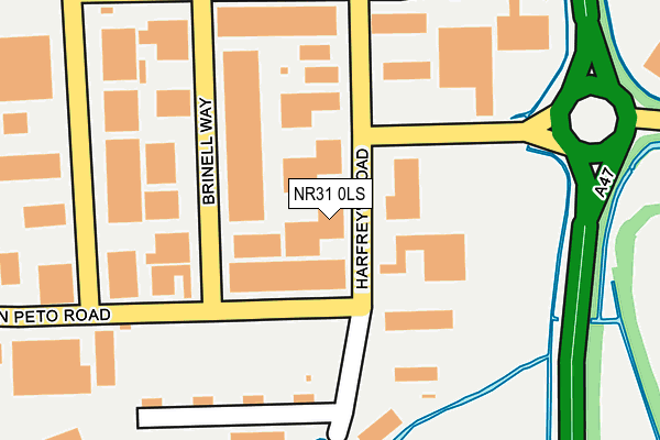
NR31 0LS is located in the Southtown and Cobholm electoral ward, within the local authority district of Great Yarmouth and the English Parliamentary constituency of Great Yarmouth. The Sub Integrated Care Board (ICB) Location is NHS Norfolk and Waveney ICB - 26A and the police force is Norfolk. This postcode has been in use since January 1980.


GetTheData
Source: OS OpenMap – Local (Ordnance Survey)
Source: OS VectorMap District (Ordnance Survey)
Licence: Open Government Licence (requires attribution)
| Easting | 651812 |
| Northing | 305796 |
| Latitude | 52.591576 |
| Longitude | 1.716364 |
GetTheData
Source: Open Postcode Geo
Licence: Open Government Licence
| Country | England |
| Postcode District | NR31 |
➜ See where NR31 is on a map ➜ Where is Great Yarmouth? | |
GetTheData
Source: Land Registry Price Paid Data
Licence: Open Government Licence
Elevation or altitude of NR31 0LS as distance above sea level:
| Metres | Feet | |
|---|---|---|
| Elevation | 0m | 0ft |
Elevation is measured from the approximate centre of the postcode, to the nearest point on an OS contour line from OS Terrain 50, which has contour spacing of ten vertical metres.
➜ How high above sea level am I? Find the elevation of your current position using your device's GPS.
GetTheData
Source: Open Postcode Elevation
Licence: Open Government Licence
| Ward | Southtown And Cobholm |
| Constituency | Great Yarmouth |
GetTheData
Source: ONS Postcode Database
Licence: Open Government Licence
| Boundary Road (Bessemer Way) | Great Yarmouth | 290m |
| Brinell Way (Boundary Road) | Great Yarmouth | 291m |
| Faraday Road (Morton Peto Road) | Great Yarmouth | 453m |
| Townlands (Burgh Road) | Gorleston | 591m |
| Waveney Road (Southtown Road) | Great Yarmouth | 619m |
| Great Yarmouth Station | 2.3km |
GetTheData
Source: NaPTAN
Licence: Open Government Licence
| Median download speed | 68.7Mbps |
| Average download speed | 46.0Mbps |
| Maximum download speed | 80.00Mbps |
| Median upload speed | 13.4Mbps |
| Average upload speed | 10.1Mbps |
| Maximum upload speed | 17.75Mbps |
GetTheData
Source: Ofcom
Licence: Ofcom Terms of Use (requires attribution)
Estimated total energy consumption in NR31 0LS by fuel type, 2015.
| Consumption (kWh) | 169,216 |
|---|---|
| Meter count | 6 |
| Mean (kWh/meter) | 28,203 |
| Median (kWh/meter) | 23,920 |
GetTheData
Source: Postcode level gas estimates: 2015 (experimental)
Source: Postcode level electricity estimates: 2015 (experimental)
Licence: Open Government Licence
GetTheData
Source: ONS Postcode Database
Licence: Open Government Licence


➜ Get more ratings from the Food Standards Agency
GetTheData
Source: Food Standards Agency
Licence: FSA terms & conditions
| Last Collection | |||
|---|---|---|---|
| Location | Mon-Fri | Sat | Distance |
| Boundary Road | 17:30 | 12:30 | 218m |
| Morton Peto Road | 17:30 | 12:30 | 446m |
| Morton Peto Road | 17:30 | 449m | |
GetTheData
Source: Dracos
Licence: Creative Commons Attribution-ShareAlike
| Risk of NR31 0LS flooding from rivers and sea | Very Low |
| ➜ NR31 0LS flood map | |
GetTheData
Source: Open Flood Risk by Postcode
Licence: Open Government Licence
The below table lists the International Territorial Level (ITL) codes (formerly Nomenclature of Territorial Units for Statistics (NUTS) codes) and Local Administrative Units (LAU) codes for NR31 0LS:
| ITL 1 Code | Name |
|---|---|
| TLH | East |
| ITL 2 Code | Name |
| TLH1 | East Anglia |
| ITL 3 Code | Name |
| TLH15 | Norwich and East Norfolk |
| LAU 1 Code | Name |
| E07000145 | Great Yarmouth |
GetTheData
Source: ONS Postcode Directory
Licence: Open Government Licence
The below table lists the Census Output Area (OA), Lower Layer Super Output Area (LSOA), and Middle Layer Super Output Area (MSOA) for NR31 0LS:
| Code | Name | |
|---|---|---|
| OA | E00135346 | |
| LSOA | E01026633 | Great Yarmouth 007B |
| MSOA | E02005544 | Great Yarmouth 007 |
GetTheData
Source: ONS Postcode Directory
Licence: Open Government Licence
| NR31 0LX | Bessemer Way | 234m |
| NR31 0LY | Boundary Road | 261m |
| NR31 0LT | Morton Peto Road | 325m |
| NR31 0NH | Sinclair Court | 407m |
| NR31 8TJ | Castle Green | 434m |
| NR31 0QF | Common Road | 439m |
| NR31 0LG | Valentine Cottages | 475m |
| NR31 8BQ | Townlands | 483m |
| NR31 0QD | Suffolk Close | 489m |
| NR31 0LE | Queen Annes Road | 518m |
GetTheData
Source: Open Postcode Geo; Land Registry Price Paid Data
Licence: Open Government Licence