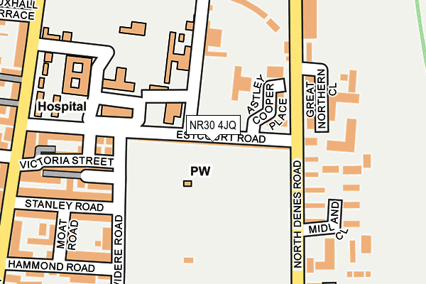
NR30 4JQ lies on Estcourt Road in Great Yarmouth. NR30 4JQ is located in the Central and Northgate electoral ward, within the local authority district of Great Yarmouth and the English Parliamentary constituency of Great Yarmouth. The Sub Integrated Care Board (ICB) Location is NHS Norfolk and Waveney ICB - 26A and the police force is Norfolk. This postcode has been in use since January 1980.


GetTheData
Source: OS OpenMap – Local (Ordnance Survey)
Source: OS VectorMap District (Ordnance Survey)
Licence: Open Government Licence (requires attribution)
| Easting | 652710 |
| Northing | 308580 |
| Latitude | 52.616161 |
| Longitude | 1.731739 |
GetTheData
Source: Open Postcode Geo
Licence: Open Government Licence
| Street | Estcourt Road |
| Town/City | Great Yarmouth |
| Country | England |
| Postcode District | NR30 |
➜ See where NR30 is on a map ➜ Where is Great Yarmouth? | |
GetTheData
Source: Land Registry Price Paid Data
Licence: Open Government Licence
Elevation or altitude of NR30 4JQ as distance above sea level:
| Metres | Feet | |
|---|---|---|
| Elevation | 0m | 0ft |
Elevation is measured from the approximate centre of the postcode, to the nearest point on an OS contour line from OS Terrain 50, which has contour spacing of ten vertical metres.
➜ How high above sea level am I? Find the elevation of your current position using your device's GPS.
GetTheData
Source: Open Postcode Elevation
Licence: Open Government Licence
| Ward | Central And Northgate |
| Constituency | Great Yarmouth |
GetTheData
Source: ONS Postcode Database
Licence: Open Government Licence
THE OLD BAKE HOUSE, ESTCOURT ROAD, GREAT YARMOUTH, NR30 4JQ 2005 7 OCT £30,000 |
GetTheData
Source: HM Land Registry Price Paid Data
Licence: Contains HM Land Registry data © Crown copyright and database right 2025. This data is licensed under the Open Government Licence v3.0.
| Midland Close (North Denes Road) | Great Yarmouth | 139m |
| Walpole Road (Beaconsfield Road) | Great Yarmouth | 258m |
| Apollo Walk (Northgate Street) | Great Yarmouth | 266m |
| Walpole Road (Beaconsfield Road) | Great Yarmouth | 267m |
| Stanley Road (Northgate Street) | Great Yarmouth | 286m |
| Great Yarmouth Station | 0.9km |
GetTheData
Source: NaPTAN
Licence: Open Government Licence
GetTheData
Source: ONS Postcode Database
Licence: Open Government Licence


➜ Get more ratings from the Food Standards Agency
GetTheData
Source: Food Standards Agency
Licence: FSA terms & conditions
| Last Collection | |||
|---|---|---|---|
| Location | Mon-Fri | Sat | Distance |
| North Denes Post Office | 18:30 | 11:45 | 452m |
| Royal Mail 6 North Quay | 18:30 | 13:00 | 620m |
| St Nicholas Road | 17:45 | 12:00 | 678m |
GetTheData
Source: Dracos
Licence: Creative Commons Attribution-ShareAlike
| Risk of NR30 4JQ flooding from rivers and sea | Very Low |
| ➜ NR30 4JQ flood map | |
GetTheData
Source: Open Flood Risk by Postcode
Licence: Open Government Licence
The below table lists the International Territorial Level (ITL) codes (formerly Nomenclature of Territorial Units for Statistics (NUTS) codes) and Local Administrative Units (LAU) codes for NR30 4JQ:
| ITL 1 Code | Name |
|---|---|
| TLH | East |
| ITL 2 Code | Name |
| TLH1 | East Anglia |
| ITL 3 Code | Name |
| TLH15 | Norwich and East Norfolk |
| LAU 1 Code | Name |
| E07000145 | Great Yarmouth |
GetTheData
Source: ONS Postcode Directory
Licence: Open Government Licence
The below table lists the Census Output Area (OA), Lower Layer Super Output Area (LSOA), and Middle Layer Super Output Area (MSOA) for NR30 4JQ:
| Code | Name | |
|---|---|---|
| OA | E00135164 | |
| LSOA | E01026595 | Great Yarmouth 005A |
| MSOA | E02005542 | Great Yarmouth 005 |
GetTheData
Source: ONS Postcode Directory
Licence: Open Government Licence
| NR30 4LJ | Reginald Court | 135m |
| NR30 4JD | Maud Terrace | 159m |
| NR30 4JF | Mission Place | 169m |
| NR30 4NT | North Denes Road | 171m |
| NR30 4NR | Midland Close | 180m |
| NR30 4HZ | Belvidere Road | 190m |
| NR30 4JG | Estcourt Road | 203m |
| NR30 4NS | Great Northern Close | 203m |
| NR30 4JE | Victoria Street | 208m |
| NR30 4JB | Stanley Road | 219m |
GetTheData
Source: Open Postcode Geo; Land Registry Price Paid Data
Licence: Open Government Licence