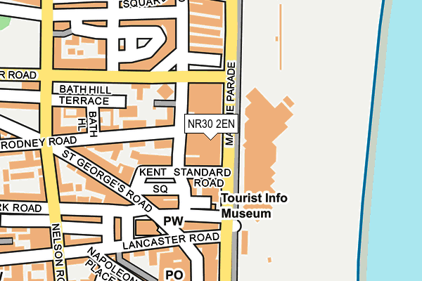
NR30 2EN lies on Marine Parade in Great Yarmouth. NR30 2EN is located in the Nelson electoral ward, within the local authority district of Great Yarmouth and the English Parliamentary constituency of Great Yarmouth. The Sub Integrated Care Board (ICB) Location is NHS Norfolk and Waveney ICB - 26A and the police force is Norfolk. This postcode has been in use since January 1980.


GetTheData
Source: OS OpenMap – Local (Ordnance Survey)
Source: OS VectorMap District (Ordnance Survey)
Licence: Open Government Licence (requires attribution)
| Easting | 653079 |
| Northing | 307296 |
| Latitude | 52.604445 |
| Longitude | 1.736173 |
GetTheData
Source: Open Postcode Geo
Licence: Open Government Licence
| Street | Marine Parade |
| Town/City | Great Yarmouth |
| Country | England |
| Postcode District | NR30 |
➜ See where NR30 is on a map ➜ Where is Great Yarmouth? | |
GetTheData
Source: Land Registry Price Paid Data
Licence: Open Government Licence
Elevation or altitude of NR30 2EN as distance above sea level:
| Metres | Feet | |
|---|---|---|
| Elevation | 0m | 0ft |
Elevation is measured from the approximate centre of the postcode, to the nearest point on an OS contour line from OS Terrain 50, which has contour spacing of ten vertical metres.
➜ How high above sea level am I? Find the elevation of your current position using your device's GPS.
GetTheData
Source: Open Postcode Elevation
Licence: Open Government Licence
| Ward | Nelson |
| Constituency | Great Yarmouth |
GetTheData
Source: ONS Postcode Database
Licence: Open Government Licence
34, MARINE PARADE, GREAT YARMOUTH, NR30 2EN 2006 30 MAR £750,000 |
GetTheData
Source: HM Land Registry Price Paid Data
Licence: Contains HM Land Registry data © Crown copyright and database right 2024. This data is licensed under the Open Government Licence v3.0.
| Marina Centre (Marine Parade) | Great Yarmouth | 24m |
| Marina Centre (Marine Parade) | Great Yarmouth | 48m |
| Leisureland (Marine Parade) | Great Yarmouth | 169m |
| Leisureland (Marine Parade) | Great Yarmouth | 183m |
| St Peters Road (Marine Parade) | Great Yarmouth | 188m |
| Great Yarmouth Station | 1.3km |
GetTheData
Source: NaPTAN
Licence: Open Government Licence
Estimated total energy consumption in NR30 2EN by fuel type, 2015.
| Consumption (kWh) | 112,410 |
|---|---|
| Meter count | 7 |
| Mean (kWh/meter) | 16,059 |
| Median (kWh/meter) | 3,284 |
GetTheData
Source: Postcode level gas estimates: 2015 (experimental)
Source: Postcode level electricity estimates: 2015 (experimental)
Licence: Open Government Licence
GetTheData
Source: ONS Postcode Database
Licence: Open Government Licence


➜ Get more ratings from the Food Standards Agency
GetTheData
Source: Food Standards Agency
Licence: FSA terms & conditions
| Last Collection | |||
|---|---|---|---|
| Location | Mon-Fri | Sat | Distance |
| St. Georges Road | 17:45 | 11:30 | 240m |
| Regent Street Post Office | 17:00 | 11:30 | 393m |
| King Street | 17:15 | 11:30 | 442m |
GetTheData
Source: Dracos
Licence: Creative Commons Attribution-ShareAlike
The below table lists the International Territorial Level (ITL) codes (formerly Nomenclature of Territorial Units for Statistics (NUTS) codes) and Local Administrative Units (LAU) codes for NR30 2EN:
| ITL 1 Code | Name |
|---|---|
| TLH | East |
| ITL 2 Code | Name |
| TLH1 | East Anglia |
| ITL 3 Code | Name |
| TLH15 | Norwich and East Norfolk |
| LAU 1 Code | Name |
| E07000145 | Great Yarmouth |
GetTheData
Source: ONS Postcode Directory
Licence: Open Government Licence
The below table lists the Census Output Area (OA), Lower Layer Super Output Area (LSOA), and Middle Layer Super Output Area (MSOA) for NR30 2EN:
| Code | Name | |
|---|---|---|
| OA | E00169829 | |
| LSOA | E01026626 | Great Yarmouth 006E |
| MSOA | E02005543 | Great Yarmouth 006 |
GetTheData
Source: ONS Postcode Directory
Licence: Open Government Licence
| NR30 2EZ | Standard Road | 58m |
| NR30 2EX | Kent Square | 68m |
| NR30 2EP | Edinburgh Place | 80m |
| NR30 2LX | Trafalgar Court | 92m |
| NR30 2NE | York Road | 107m |
| NR30 2DA | Kent Mews | 115m |
| NR30 2EL | Trafalgar Square | 128m |
| NR30 2FG | Kent Square | 129m |
| NR30 2EJ | Marine Parade | 130m |
| NR30 2JU | Paston Place | 139m |
GetTheData
Source: Open Postcode Geo; Land Registry Price Paid Data
Licence: Open Government Licence