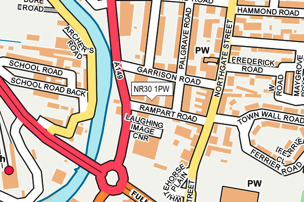
NR30 1PW is located in the Central and Northgate electoral ward, within the local authority district of Great Yarmouth and the English Parliamentary constituency of Great Yarmouth. The Sub Integrated Care Board (ICB) Location is NHS Norfolk and Waveney ICB - 26A and the police force is Norfolk. This postcode has been in use since January 1992.


GetTheData
Source: OS OpenMap – Local (Ordnance Survey)
Source: OS VectorMap District (Ordnance Survey)
Licence: Open Government Licence (requires attribution)
| Easting | 652268 |
| Northing | 308227 |
| Latitude | 52.613173 |
| Longitude | 1.724933 |
GetTheData
Source: Open Postcode Geo
Licence: Open Government Licence
| Country | England |
| Postcode District | NR30 |
➜ See where NR30 is on a map ➜ Where is Great Yarmouth? | |
GetTheData
Source: Land Registry Price Paid Data
Licence: Open Government Licence
Elevation or altitude of NR30 1PW as distance above sea level:
| Metres | Feet | |
|---|---|---|
| Elevation | 0m | 0ft |
Elevation is measured from the approximate centre of the postcode, to the nearest point on an OS contour line from OS Terrain 50, which has contour spacing of ten vertical metres.
➜ How high above sea level am I? Find the elevation of your current position using your device's GPS.
GetTheData
Source: Open Postcode Elevation
Licence: Open Government Licence
| Ward | Central And Northgate |
| Constituency | Great Yarmouth |
GetTheData
Source: ONS Postcode Database
Licence: Open Government Licence
| Frederick Road (Northgate Street) | Great Yarmouth | 155m |
| White Horse Plain (Northgate Street) | Great Yarmouth | 162m |
| St. Nicholas's Church (Northgate Street) | Great Yarmouth | 230m |
| Ormond Road (Northgate Street) | Great Yarmouth | 238m |
| Station Forecourt (Acle New Road) | Great Yarmouth | 288m |
| Great Yarmouth Station | 0.3km |
GetTheData
Source: NaPTAN
Licence: Open Government Licence
GetTheData
Source: ONS Postcode Database
Licence: Open Government Licence


➜ Get more ratings from the Food Standards Agency
GetTheData
Source: Food Standards Agency
Licence: FSA terms & conditions
| Last Collection | |||
|---|---|---|---|
| Location | Mon-Fri | Sat | Distance |
| Royal Mail 6 North Quay | 18:30 | 13:00 | 67m |
| Vauxhall Station | 18:30 | 11:30 | 297m |
| The Conge | 18:30 | 12:00 | 346m |
GetTheData
Source: Dracos
Licence: Creative Commons Attribution-ShareAlike
The below table lists the International Territorial Level (ITL) codes (formerly Nomenclature of Territorial Units for Statistics (NUTS) codes) and Local Administrative Units (LAU) codes for NR30 1PW:
| ITL 1 Code | Name |
|---|---|
| TLH | East |
| ITL 2 Code | Name |
| TLH1 | East Anglia |
| ITL 3 Code | Name |
| TLH15 | Norwich and East Norfolk |
| LAU 1 Code | Name |
| E07000145 | Great Yarmouth |
GetTheData
Source: ONS Postcode Directory
Licence: Open Government Licence
The below table lists the Census Output Area (OA), Lower Layer Super Output Area (LSOA), and Middle Layer Super Output Area (MSOA) for NR30 1PW:
| Code | Name | |
|---|---|---|
| OA | E00135166 | |
| LSOA | E01026596 | Great Yarmouth 005B |
| MSOA | E02005542 | Great Yarmouth 005 |
GetTheData
Source: ONS Postcode Directory
Licence: Open Government Licence
| NR30 1PY | Palgrave Road | 66m |
| NR30 1PZ | Garrison Road | 75m |
| NR30 1PX | Rampart Road | 80m |
| NR30 1BH | Northgate Street | 105m |
| NR30 1BA | Northgate Street | 123m |
| NR30 1BF | Whitehorse Terrace | 130m |
| NR30 1JY | North River Road | 132m |
| NR30 1BG | Northgate Street | 141m |
| NR30 1DH | Northgate Street | 148m |
| NR30 1QL | Alderson Road | 149m |
GetTheData
Source: Open Postcode Geo; Land Registry Price Paid Data
Licence: Open Government Licence