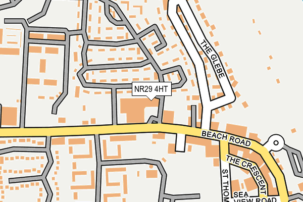
NR29 4HT is located in the East Flegg electoral ward, within the local authority district of Great Yarmouth and the English Parliamentary constituency of Great Yarmouth. The Sub Integrated Care Board (ICB) Location is NHS Norfolk and Waveney ICB - 26A and the police force is Norfolk. This postcode has been in use since January 1980.


GetTheData
Source: OS OpenMap – Local (Ordnance Survey)
Source: OS VectorMap District (Ordnance Survey)
Licence: Open Government Licence (requires attribution)
| Easting | 650360 |
| Northing | 317418 |
| Latitude | 52.696507 |
| Longitude | 1.703783 |
GetTheData
Source: Open Postcode Geo
Licence: Open Government Licence
| Country | England |
| Postcode District | NR29 |
➜ See where NR29 is on a map ➜ Where is Hemsby? | |
GetTheData
Source: Land Registry Price Paid Data
Licence: Open Government Licence
Elevation or altitude of NR29 4HT as distance above sea level:
| Metres | Feet | |
|---|---|---|
| Elevation | 10m | 33ft |
Elevation is measured from the approximate centre of the postcode, to the nearest point on an OS contour line from OS Terrain 50, which has contour spacing of ten vertical metres.
➜ How high above sea level am I? Find the elevation of your current position using your device's GPS.
GetTheData
Source: Open Postcode Elevation
Licence: Open Government Licence
| Ward | East Flegg |
| Constituency | Great Yarmouth |
GetTheData
Source: ONS Postcode Database
Licence: Open Government Licence
| Beach Turning Circle (Beach Road) | Hemsby | 44m |
| Seacroft Holiday Centre (Beach Road) | Hemsby | 357m |
| Seacroft Holiday Centre (Beach Road) | Hemsby | 388m |
| Back Market Lane (Beach Road) | Hemsby | 535m |
| Back Market Lane (Beach Road) | Hemsby | 550m |
GetTheData
Source: NaPTAN
Licence: Open Government Licence
GetTheData
Source: ONS Postcode Database
Licence: Open Government Licence


➜ Get more ratings from the Food Standards Agency
GetTheData
Source: Food Standards Agency
Licence: FSA terms & conditions
| Last Collection | |||
|---|---|---|---|
| Location | Mon-Fri | Sat | Distance |
| Winterton Post Office | 17:00 | 12:00 | 2,257m |
| Main Road | 16:00 | 09:00 | 3,637m |
| The Staithe | 16:00 | 09:00 | 4,366m |
GetTheData
Source: Dracos
Licence: Creative Commons Attribution-ShareAlike
The below table lists the International Territorial Level (ITL) codes (formerly Nomenclature of Territorial Units for Statistics (NUTS) codes) and Local Administrative Units (LAU) codes for NR29 4HT:
| ITL 1 Code | Name |
|---|---|
| TLH | East |
| ITL 2 Code | Name |
| TLH1 | East Anglia |
| ITL 3 Code | Name |
| TLH15 | Norwich and East Norfolk |
| LAU 1 Code | Name |
| E07000145 | Great Yarmouth |
GetTheData
Source: ONS Postcode Directory
Licence: Open Government Licence
The below table lists the Census Output Area (OA), Lower Layer Super Output Area (LSOA), and Middle Layer Super Output Area (MSOA) for NR29 4HT:
| Code | Name | |
|---|---|---|
| OA | E00135197 | |
| LSOA | E01026607 | Great Yarmouth 001C |
| MSOA | E02005538 | Great Yarmouth 001 |
GetTheData
Source: ONS Postcode Directory
Licence: Open Government Licence
| NR29 4HS | Beach Road | 97m |
| NR29 4HZ | Beach Road | 128m |
| NR29 4HU | Seadell Holiday Estate | 270m |
| NR29 4JF | The Crescent | 295m |
| NR29 4JE | St Thomass Road | 300m |
| NR29 4JB | Four Acres Estate | 303m |
| NR29 4JG | Sea View Road | 339m |
| NR29 4HY | Seadell Holiday Estate | 398m |
| NR29 4JH | South Road | 416m |
| NR29 4HN | Kings Loke | 499m |
GetTheData
Source: Open Postcode Geo; Land Registry Price Paid Data
Licence: Open Government Licence