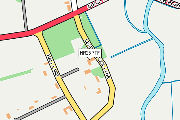
NR25 7TF lies on Leatherpool Lane in Wiveton, Holt. NR25 7TF is located in the Coastal electoral ward, within the local authority district of North Norfolk and the English Parliamentary constituency of North Norfolk. The Sub Integrated Care Board (ICB) Location is NHS Norfolk and Waveney ICB - 26A and the police force is Norfolk. This postcode has been in use since January 1980.


GetTheData
Source: OS OpenMap – Local (Ordnance Survey)
Source: OS VectorMap District (Ordnance Survey)
Licence: Open Government Licence (requires attribution)
| Easting | 604160 |
| Northing | 343511 |
| Latitude | 52.950145 |
| Longitude | 1.037520 |
GetTheData
Source: Open Postcode Geo
Licence: Open Government Licence
| Street | Leatherpool Lane |
| Locality | Wiveton |
| Town/City | Holt |
| Country | England |
| Postcode District | NR25 |
➜ See where NR25 is on a map ➜ Where is Wiveton? | |
GetTheData
Source: Land Registry Price Paid Data
Licence: Open Government Licence
Elevation or altitude of NR25 7TF as distance above sea level:
| Metres | Feet | |
|---|---|---|
| Elevation | 10m | 33ft |
Elevation is measured from the approximate centre of the postcode, to the nearest point on an OS contour line from OS Terrain 50, which has contour spacing of ten vertical metres.
➜ How high above sea level am I? Find the elevation of your current position using your device's GPS.
GetTheData
Source: Open Postcode Elevation
Licence: Open Government Licence
| Ward | Coastal |
| Constituency | North Norfolk |
GetTheData
Source: ONS Postcode Database
Licence: Open Government Licence
| Delicatessen (Coast Road) | Cley Next The Sea | 398m |
| Delicatessen (Coast Road) | Cley Next The Sea | 415m |
| Three Swallows (Holt Road) | Cley Next The Sea | 707m |
| Three Swallows (Holt Road) | Cley Next The Sea | 742m |
| Wiveton Bell (Bridgefoot Lane) | Wiveton | 748m |
GetTheData
Source: NaPTAN
Licence: Open Government Licence
| Percentage of properties with Next Generation Access | 100.0% |
| Percentage of properties with Superfast Broadband | 100.0% |
| Percentage of properties with Ultrafast Broadband | 0.0% |
| Percentage of properties with Full Fibre Broadband | 0.0% |
Superfast Broadband is between 30Mbps and 300Mbps
Ultrafast Broadband is > 300Mbps
| Percentage of properties unable to receive 2Mbps | 0.0% |
| Percentage of properties unable to receive 5Mbps | 0.0% |
| Percentage of properties unable to receive 10Mbps | 0.0% |
| Percentage of properties unable to receive 30Mbps | 0.0% |
GetTheData
Source: Ofcom
Licence: Ofcom Terms of Use (requires attribution)
GetTheData
Source: ONS Postcode Database
Licence: Open Government Licence


➜ Get more ratings from the Food Standards Agency
GetTheData
Source: Food Standards Agency
Licence: FSA terms & conditions
| Last Collection | |||
|---|---|---|---|
| Location | Mon-Fri | Sat | Distance |
| Hall Lane | 16:10 | 11:30 | 231m |
| Holt Road Post Office | 16:00 | 10:00 | 425m |
| Iron Box Corner | 16:00 | 11:30 | 480m |
GetTheData
Source: Dracos
Licence: Creative Commons Attribution-ShareAlike
| Risk of NR25 7TF flooding from rivers and sea | Very Low |
| ➜ NR25 7TF flood map | |
GetTheData
Source: Open Flood Risk by Postcode
Licence: Open Government Licence
The below table lists the International Territorial Level (ITL) codes (formerly Nomenclature of Territorial Units for Statistics (NUTS) codes) and Local Administrative Units (LAU) codes for NR25 7TF:
| ITL 1 Code | Name |
|---|---|
| TLH | East |
| ITL 2 Code | Name |
| TLH1 | East Anglia |
| ITL 3 Code | Name |
| TLH16 | North and West Norfolk |
| LAU 1 Code | Name |
| E07000147 | North Norfolk |
GetTheData
Source: ONS Postcode Directory
Licence: Open Government Licence
The below table lists the Census Output Area (OA), Lower Layer Super Output Area (LSOA), and Middle Layer Super Output Area (MSOA) for NR25 7TF:
| Code | Name | |
|---|---|---|
| OA | E00135937 | |
| LSOA | E01026739 | North Norfolk 002A |
| MSOA | E02005571 | North Norfolk 002 |
GetTheData
Source: ONS Postcode Directory
Licence: Open Government Licence
| NR25 7TG | Hall Lane | 155m |
| NR25 7TH | The Street | 352m |
| NR25 7TQ | Chapel Street | 352m |
| NR25 7RA | New Road | 417m |
| NR25 7AP | High Street | 419m |
| NR25 7RG | High Street | 448m |
| NR25 7RB | High Street | 452m |
| NR25 7UA | Holt Road | 468m |
| NR25 7RF | High Street | 468m |
| NR25 7RE | Wrights Yard | 483m |
GetTheData
Source: Open Postcode Geo; Land Registry Price Paid Data
Licence: Open Government Licence