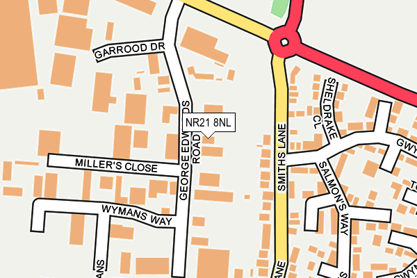
NR21 8NL is located in the Lancaster South electoral ward, within the local authority district of North Norfolk and the English Parliamentary constituency of Broadland. The Sub Integrated Care Board (ICB) Location is NHS Norfolk and Waveney ICB - 26A and the police force is Norfolk. This postcode has been in use since January 1980.


GetTheData
Source: OS OpenMap – Local (Ordnance Survey)
Source: OS VectorMap District (Ordnance Survey)
Licence: Open Government Licence (requires attribution)
| Easting | 593338 |
| Northing | 330153 |
| Latitude | 52.834220 |
| Longitude | 0.868727 |
GetTheData
Source: Open Postcode Geo
Licence: Open Government Licence
| Country | England |
| Postcode District | NR21 |
➜ See where NR21 is on a map ➜ Where is Fakenham? | |
GetTheData
Source: Land Registry Price Paid Data
Licence: Open Government Licence
Elevation or altitude of NR21 8NL as distance above sea level:
| Metres | Feet | |
|---|---|---|
| Elevation | 50m | 164ft |
Elevation is measured from the approximate centre of the postcode, to the nearest point on an OS contour line from OS Terrain 50, which has contour spacing of ten vertical metres.
➜ How high above sea level am I? Find the elevation of your current position using your device's GPS.
GetTheData
Source: Open Postcode Elevation
Licence: Open Government Licence
| Ward | Lancaster South |
| Constituency | Broadland |
GetTheData
Source: ONS Postcode Database
Licence: Open Government Licence
| Gwyn Crescent (Smiths Lane) | Fakenham | 93m |
| North Of Gwyn Crescent (Smiths Lane) | Fakenham | 112m |
| George Edwards Road (Holt Road) | Fakenham | 193m |
| George Edwards Road (Holt Road) | Fakenham | 247m |
| Norwich Road (Smiths Lane) | Fakenham | 315m |
GetTheData
Source: NaPTAN
Licence: Open Government Licence
| Median download speed | 37.5Mbps |
| Average download speed | 36.9Mbps |
| Maximum download speed | 74.64Mbps |
| Median upload speed | 8.3Mbps |
| Average upload speed | 7.1Mbps |
| Maximum upload speed | 15.79Mbps |
GetTheData
Source: Ofcom
Licence: Ofcom Terms of Use (requires attribution)
Estimated total energy consumption in NR21 8NL by fuel type, 2015.
| Consumption (kWh) | 244,326 |
|---|---|
| Meter count | 14 |
| Mean (kWh/meter) | 17,452 |
| Median (kWh/meter) | 16,254 |
GetTheData
Source: Postcode level gas estimates: 2015 (experimental)
Source: Postcode level electricity estimates: 2015 (experimental)
Licence: Open Government Licence
GetTheData
Source: ONS Postcode Database
Licence: Open Government Licence


➜ Get more ratings from the Food Standards Agency
GetTheData
Source: Food Standards Agency
Licence: FSA terms & conditions
| Last Collection | |||
|---|---|---|---|
| Location | Mon-Fri | Sat | Distance |
| George Edwards Road | 17:15 | 11:30 | 121m |
| Safeways Clipbush Road | 16:30 | 11:00 | 519m |
| Lee Warner Avenue | 16:45 | 11:15 | 734m |
GetTheData
Source: Dracos
Licence: Creative Commons Attribution-ShareAlike
The below table lists the International Territorial Level (ITL) codes (formerly Nomenclature of Territorial Units for Statistics (NUTS) codes) and Local Administrative Units (LAU) codes for NR21 8NL:
| ITL 1 Code | Name |
|---|---|
| TLH | East |
| ITL 2 Code | Name |
| TLH1 | East Anglia |
| ITL 3 Code | Name |
| TLH16 | North and West Norfolk |
| LAU 1 Code | Name |
| E07000147 | North Norfolk |
GetTheData
Source: ONS Postcode Directory
Licence: Open Government Licence
The below table lists the Census Output Area (OA), Lower Layer Super Output Area (LSOA), and Middle Layer Super Output Area (MSOA) for NR21 8NL:
| Code | Name | |
|---|---|---|
| OA | E00135988 | |
| LSOA | E01026748 | North Norfolk 011D |
| MSOA | E02005580 | North Norfolk 011 |
GetTheData
Source: ONS Postcode Directory
Licence: Open Government Licence
| NR21 8NB | Gwyn Crescent | 136m |
| NR21 8LS | Smiths Lane | 146m |
| NR21 8ND | Sheldrake Close | 163m |
| NR21 8LQ | Smiths Lane | 167m |
| NR21 8LG | Smiths Lane | 196m |
| NR21 8NG | Salmons Way | 230m |
| NR21 8NF | Townshend Green North | 234m |
| NR21 8NQ | Townshend Green West | 243m |
| NR21 8HX | Heath Rise | 269m |
| NR21 8HY | Heath Rise | 302m |
GetTheData
Source: Open Postcode Geo; Land Registry Price Paid Data
Licence: Open Government Licence