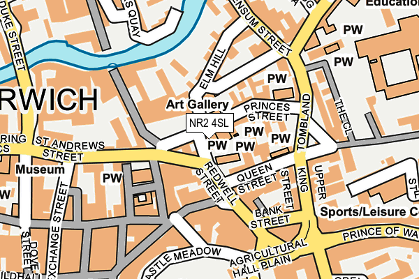
NR2 4SL lies on Redwell Street in Norwich. NR2 4SL is located in the Thorpe Hamlet electoral ward, within the local authority district of Norwich and the English Parliamentary constituency of Norwich South. The Sub Integrated Care Board (ICB) Location is NHS Norfolk and Waveney ICB - 26A and the police force is Norfolk. This postcode has been in use since June 1999.


GetTheData
Source: OS OpenMap – Local (Ordnance Survey)
Source: OS VectorMap District (Ordnance Survey)
Licence: Open Government Licence (requires attribution)
| Easting | 623208 |
| Northing | 308768 |
| Latitude | 52.630739 |
| Longitude | 1.296862 |
GetTheData
Source: Open Postcode Geo
Licence: Open Government Licence
| Street | Redwell Street |
| Town/City | Norwich |
| Country | England |
| Postcode District | NR2 |
➜ See where NR2 is on a map ➜ Where is Norwich? | |
GetTheData
Source: Land Registry Price Paid Data
Licence: Open Government Licence
Elevation or altitude of NR2 4SL as distance above sea level:
| Metres | Feet | |
|---|---|---|
| Elevation | 10m | 33ft |
Elevation is measured from the approximate centre of the postcode, to the nearest point on an OS contour line from OS Terrain 50, which has contour spacing of ten vertical metres.
➜ How high above sea level am I? Find the elevation of your current position using your device's GPS.
GetTheData
Source: Open Postcode Elevation
Licence: Open Government Licence
| Ward | Thorpe Hamlet |
| Constituency | Norwich South |
GetTheData
Source: ONS Postcode Database
Licence: Open Government Licence
| St Andrews House (St Andrews Street) | Norwich | 116m |
| Bank Street (Bank Plain) | Norwich | 116m |
| Bank Street (Bank Plain) | Norwich | 121m |
| Tombland | Norwich | 128m |
| Tombland | Norwich | 132m |
| Norwich Station | 0.8km |
GetTheData
Source: NaPTAN
Licence: Open Government Licence
GetTheData
Source: ONS Postcode Database
Licence: Open Government Licence


➜ Get more ratings from the Food Standards Agency
GetTheData
Source: Food Standards Agency
Licence: FSA terms & conditions
| Last Collection | |||
|---|---|---|---|
| Location | Mon-Fri | Sat | Distance |
| Bank Plain Business Box | 19:00 | 11:00 | 115m |
| Bank Plain | 19:00 | 11:00 | 118m |
| Opie Street | 18:45 | 11:00 | 131m |
GetTheData
Source: Dracos
Licence: Creative Commons Attribution-ShareAlike
The below table lists the International Territorial Level (ITL) codes (formerly Nomenclature of Territorial Units for Statistics (NUTS) codes) and Local Administrative Units (LAU) codes for NR2 4SL:
| ITL 1 Code | Name |
|---|---|
| TLH | East |
| ITL 2 Code | Name |
| TLH1 | East Anglia |
| ITL 3 Code | Name |
| TLH15 | Norwich and East Norfolk |
| LAU 1 Code | Name |
| E07000148 | Norwich |
GetTheData
Source: ONS Postcode Directory
Licence: Open Government Licence
The below table lists the Census Output Area (OA), Lower Layer Super Output Area (LSOA), and Middle Layer Super Output Area (MSOA) for NR2 4SL:
| Code | Name | |
|---|---|---|
| OA | E00136572 | |
| LSOA | E01033438 | Norwich 014A |
| MSOA | E02006907 | Norwich 014 |
GetTheData
Source: ONS Postcode Directory
Licence: Open Government Licence
| NR2 4SN | Redwell Street | 39m |
| NR3 1AU | St Andrews Hall Plain | 57m |
| NR3 1HN | Elm Hill | 62m |
| NR3 1EP | St Michael At Pleas | 66m |
| NR3 1AE | Princes Street | 67m |
| NR3 1AY | Mandells Court | 73m |
| NR2 1HL | London Street | 90m |
| NR2 4SG | Queen Street | 99m |
| NR3 1JP | Norris Court | 107m |
| NR2 4SF | Bank Plain | 109m |
GetTheData
Source: Open Postcode Geo; Land Registry Price Paid Data
Licence: Open Government Licence