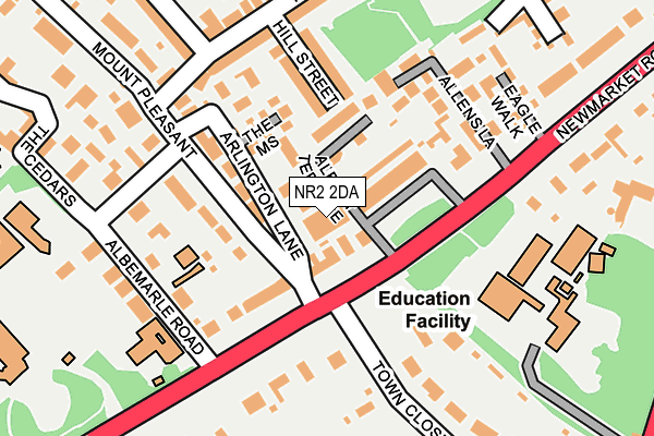
NR2 2DA lies on Arlington Lane in Norwich. NR2 2DA is located in the Eaton electoral ward, within the local authority district of Norwich and the English Parliamentary constituency of Norwich South. The Sub Integrated Care Board (ICB) Location is NHS Norfolk and Waveney ICB - 26A and the police force is Norfolk. This postcode has been in use since January 1980.


GetTheData
Source: OS OpenMap – Local (Ordnance Survey)
Source: OS VectorMap District (Ordnance Survey)
Licence: Open Government Licence (requires attribution)
| Easting | 622164 |
| Northing | 307457 |
| Latitude | 52.619401 |
| Longitude | 1.280582 |
GetTheData
Source: Open Postcode Geo
Licence: Open Government Licence
| Street | Arlington Lane |
| Town/City | Norwich |
| Country | England |
| Postcode District | NR2 |
➜ See where NR2 is on a map ➜ Where is Norwich? | |
GetTheData
Source: Land Registry Price Paid Data
Licence: Open Government Licence
Elevation or altitude of NR2 2DA as distance above sea level:
| Metres | Feet | |
|---|---|---|
| Elevation | 30m | 98ft |
Elevation is measured from the approximate centre of the postcode, to the nearest point on an OS contour line from OS Terrain 50, which has contour spacing of ten vertical metres.
➜ How high above sea level am I? Find the elevation of your current position using your device's GPS.
GetTheData
Source: Open Postcode Elevation
Licence: Open Government Licence
| Ward | Eaton |
| Constituency | Norwich South |
GetTheData
Source: ONS Postcode Database
Licence: Open Government Licence
10, ARLINGTON LANE, NORWICH, NR2 2DA 2000 6 JUN £490,000 |
GetTheData
Source: HM Land Registry Price Paid Data
Licence: Contains HM Land Registry data © Crown copyright and database right 2025. This data is licensed under the Open Government Licence v3.0.
| Town Close Road (Newmarket Road) | Norwich | 71m |
| Albemarle Road (Newmarket Road) | Norwich | 139m |
| Eagle Walk (Newmarket Road) | Norwich | 222m |
| Albemarle Road (Newmarket Road) | Norwich | 228m |
| Eagle Walk (Newmarket Road) | Norwich | 280m |
| Norwich Station | 2km |
GetTheData
Source: NaPTAN
Licence: Open Government Licence
GetTheData
Source: ONS Postcode Database
Licence: Open Government Licence


➜ Get more ratings from the Food Standards Agency
GetTheData
Source: Food Standards Agency
Licence: FSA terms & conditions
| Last Collection | |||
|---|---|---|---|
| Location | Mon-Fri | Sat | Distance |
| Newmarket Road | 18:45 | 11:00 | 76m |
| Limetree Road / Newmarket Road | 18:15 | 11:00 | 374m |
| Ipswich Road /Opp Cedric Road | 17:45 | 11:00 | 420m |
GetTheData
Source: Dracos
Licence: Creative Commons Attribution-ShareAlike
The below table lists the International Territorial Level (ITL) codes (formerly Nomenclature of Territorial Units for Statistics (NUTS) codes) and Local Administrative Units (LAU) codes for NR2 2DA:
| ITL 1 Code | Name |
|---|---|
| TLH | East |
| ITL 2 Code | Name |
| TLH1 | East Anglia |
| ITL 3 Code | Name |
| TLH15 | Norwich and East Norfolk |
| LAU 1 Code | Name |
| E07000148 | Norwich |
GetTheData
Source: ONS Postcode Directory
Licence: Open Government Licence
The below table lists the Census Output Area (OA), Lower Layer Super Output Area (LSOA), and Middle Layer Super Output Area (MSOA) for NR2 2DA:
| Code | Name | |
|---|---|---|
| OA | E00136583 | |
| LSOA | E01026857 | Norwich 011F |
| MSOA | E02005594 | Norwich 011 |
GetTheData
Source: ONS Postcode Directory
Licence: Open Government Licence
| NR2 2HW | Newmarket Road | 31m |
| NR2 2JD | Albert Terrace | 87m |
| NR2 2DG | Mount Pleasant | 98m |
| NR2 2BY | The Mews | 111m |
| NR2 2HP | Newmarket Road | 122m |
| NR2 2DB | Arlington Lane | 129m |
| NR2 2DT | Hill Street | 129m |
| NR2 2JE | Paxton Place | 142m |
| NR2 2DF | Albemarle Road | 166m |
| NR2 2JB | Allens Lane | 170m |
GetTheData
Source: Open Postcode Geo; Land Registry Price Paid Data
Licence: Open Government Licence