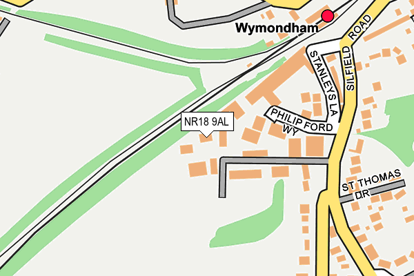
NR18 9AL is located in the South Wymondham electoral ward, within the local authority district of South Norfolk and the English Parliamentary constituency of Mid Norfolk. The Sub Integrated Care Board (ICB) Location is NHS Norfolk and Waveney ICB - 26A and the police force is Norfolk. This postcode has been in use since March 2004.


GetTheData
Source: OS OpenMap – Local (Ordnance Survey)
Source: OS VectorMap District (Ordnance Survey)
Licence: Open Government Licence (requires attribution)
| Easting | 611261 |
| Northing | 300783 |
| Latitude | 52.563840 |
| Longitude | 1.115523 |
GetTheData
Source: Open Postcode Geo
Licence: Open Government Licence
| Country | England |
| Postcode District | NR18 |
➜ See where NR18 is on a map ➜ Where is Wymondham? | |
GetTheData
Source: Land Registry Price Paid Data
Licence: Open Government Licence
Elevation or altitude of NR18 9AL as distance above sea level:
| Metres | Feet | |
|---|---|---|
| Elevation | 40m | 131ft |
Elevation is measured from the approximate centre of the postcode, to the nearest point on an OS contour line from OS Terrain 50, which has contour spacing of ten vertical metres.
➜ How high above sea level am I? Find the elevation of your current position using your device's GPS.
GetTheData
Source: Open Postcode Elevation
Licence: Open Government Licence
| Ward | South Wymondham |
| Constituency | Mid Norfolk |
GetTheData
Source: ONS Postcode Database
Licence: Open Government Licence
| Silfield Road | Silfield | 339m |
| Park Lane | Silfield | 342m |
| Station Road | Wymondham | 401m |
| Station Road | Wymondham | 415m |
| Silfield Road | Silfield | 487m |
| Wymondham Abbey (Mid Norfolk Railway) | Wymondham | 1,059m |
| Wymondham Station | 0.2km |
| Spooner Row Station | 3.8km |
GetTheData
Source: NaPTAN
Licence: Open Government Licence
GetTheData
Source: ONS Postcode Database
Licence: Open Government Licence


➜ Get more ratings from the Food Standards Agency
GetTheData
Source: Food Standards Agency
Licence: FSA terms & conditions
| Last Collection | |||
|---|---|---|---|
| Location | Mon-Fri | Sat | Distance |
| Ayton Road | 17:30 | 12:00 | 454m |
| Whitehorse Street | 17:30 | 11:30 | 550m |
| Green Lane Post Office | 17:15 | 12:00 | 668m |
GetTheData
Source: Dracos
Licence: Creative Commons Attribution-ShareAlike
The below table lists the International Territorial Level (ITL) codes (formerly Nomenclature of Territorial Units for Statistics (NUTS) codes) and Local Administrative Units (LAU) codes for NR18 9AL:
| ITL 1 Code | Name |
|---|---|
| TLH | East |
| ITL 2 Code | Name |
| TLH1 | East Anglia |
| ITL 3 Code | Name |
| TLH17 | Breckland and South Norfolk |
| LAU 1 Code | Name |
| E07000149 | South Norfolk |
GetTheData
Source: ONS Postcode Directory
Licence: Open Government Licence
The below table lists the Census Output Area (OA), Lower Layer Super Output Area (LSOA), and Middle Layer Super Output Area (MSOA) for NR18 9AL:
| Code | Name | |
|---|---|---|
| OA | E00136741 | |
| LSOA | E01026884 | South Norfolk 007A |
| MSOA | E02005603 | South Norfolk 007 |
GetTheData
Source: ONS Postcode Directory
Licence: Open Government Licence
| NR18 9AU | Silfield Road | 158m |
| NR18 9AT | White Villas | 203m |
| NR18 0JZ | Station Approach | 219m |
| NR18 9AR | St Thomas Drive | 269m |
| NR18 9HZ | Harry Daniels Close | 287m |
| NR18 9ND | Exige Way | 344m |
| NR18 9BG | Park Lane | 365m |
| NR18 9NZ | Bridge Loke | 385m |
| NR18 0JX | Station Road | 390m |
| NR18 9NE | Evora Road | 404m |
GetTheData
Source: Open Postcode Geo; Land Registry Price Paid Data
Licence: Open Government Licence