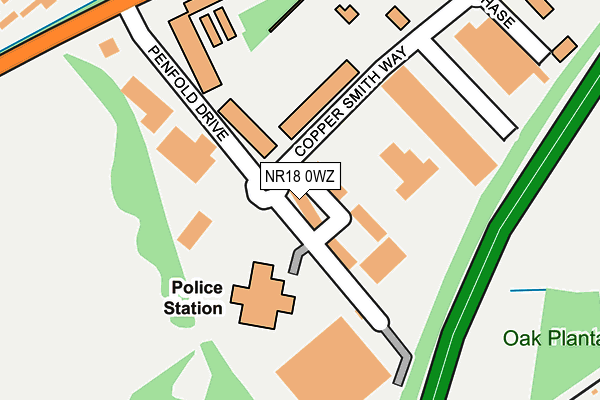
NR18 0WZ lies on Penfold Drive in Wymondham. NR18 0WZ is located in the South Wymondham electoral ward, within the local authority district of South Norfolk and the English Parliamentary constituency of Mid Norfolk. The Sub Integrated Care Board (ICB) Location is NHS Norfolk and Waveney ICB - 26A and the police force is Norfolk. This postcode has been in use since June 2000.


GetTheData
Source: OS OpenMap – Local (Ordnance Survey)
Source: OS VectorMap District (Ordnance Survey)
Licence: Open Government Licence (requires attribution)
| Easting | 612609 |
| Northing | 302187 |
| Latitude | 52.575941 |
| Longitude | 1.136302 |
GetTheData
Source: Open Postcode Geo
Licence: Open Government Licence
| Street | Penfold Drive |
| Town/City | Wymondham |
| Country | England |
| Postcode District | NR18 |
➜ See where NR18 is on a map ➜ Where is Wymondham? | |
GetTheData
Source: Land Registry Price Paid Data
Licence: Open Government Licence
Elevation or altitude of NR18 0WZ as distance above sea level:
| Metres | Feet | |
|---|---|---|
| Elevation | 50m | 164ft |
Elevation is measured from the approximate centre of the postcode, to the nearest point on an OS contour line from OS Terrain 50, which has contour spacing of ten vertical metres.
➜ How high above sea level am I? Find the elevation of your current position using your device's GPS.
GetTheData
Source: Open Postcode Elevation
Licence: Open Government Licence
| Ward | South Wymondham |
| Constituency | Mid Norfolk |
GetTheData
Source: ONS Postcode Database
Licence: Open Government Licence
| Gateway 11 Business Park (Falconers Chase) | Wymondham | 290m |
| Waitrose (Norwich Road) | Wymondham | 415m |
| Oakwood Drive (Norwich Road) | Wymondham | 421m |
| Oakwood Drive (Norwich Road) | Wymondham | 429m |
| Waitrose (Norwich Road) | Wymondham | 437m |
| Wymondham Station | 1.7km |
| Spooner Row Station | 5.7km |
GetTheData
Source: NaPTAN
Licence: Open Government Licence
| Median download speed | 80.0Mbps |
| Average download speed | 79.7Mbps |
| Maximum download speed | 80.00Mbps |
| Median upload speed | 20.0Mbps |
| Average upload speed | 20.0Mbps |
| Maximum upload speed | 20.00Mbps |
GetTheData
Source: Ofcom
Licence: Ofcom Terms of Use (requires attribution)
GetTheData
Source: ONS Postcode Database
Licence: Open Government Licence


➜ Get more ratings from the Food Standards Agency
GetTheData
Source: Food Standards Agency
Licence: FSA terms & conditions
| Last Collection | |||
|---|---|---|---|
| Location | Mon-Fri | Sat | Distance |
| Tuttles Lane East | 17:00 | 11:45 | 551m |
| Norwich Road | 17:15 | 09:00 | 626m |
| Limetree Avenue Post Office | 17:00 | 12:00 | 792m |
GetTheData
Source: Dracos
Licence: Creative Commons Attribution-ShareAlike
The below table lists the International Territorial Level (ITL) codes (formerly Nomenclature of Territorial Units for Statistics (NUTS) codes) and Local Administrative Units (LAU) codes for NR18 0WZ:
| ITL 1 Code | Name |
|---|---|
| TLH | East |
| ITL 2 Code | Name |
| TLH1 | East Anglia |
| ITL 3 Code | Name |
| TLH17 | Breckland and South Norfolk |
| LAU 1 Code | Name |
| E07000149 | South Norfolk |
GetTheData
Source: ONS Postcode Directory
Licence: Open Government Licence
The below table lists the Census Output Area (OA), Lower Layer Super Output Area (LSOA), and Middle Layer Super Output Area (MSOA) for NR18 0WZ:
| Code | Name | |
|---|---|---|
| OA | E00174642 | |
| LSOA | E01026945 | South Norfolk 007D |
| MSOA | E02005603 | South Norfolk 007 |
GetTheData
Source: ONS Postcode Directory
Licence: Open Government Licence
| NR18 0NP | Turner Close | 366m |
| NR18 0UH | Norwich Road | 434m |
| NR18 0SJ | Norwich Road | 477m |
| NR18 0YD | Pennycress Drive | 486m |
| NR18 0UG | Oakwood Drive | 495m |
| NR18 0XY | Gatekeeper Close | 520m |
| NR18 0UR | The Loke | 528m |
| NR18 0HB | Fiona Close | 528m |
| NR18 0YE | Burdock Close | 539m |
| NR18 0XA | Fritillary Drive | 549m |
GetTheData
Source: Open Postcode Geo; Land Registry Price Paid Data
Licence: Open Government Licence