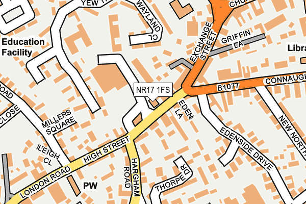
NR17 1FS is located in the Attleborough Queens & Besthorpe electoral ward, within the local authority district of Breckland and the English Parliamentary constituency of Mid Norfolk. The Sub Integrated Care Board (ICB) Location is NHS Norfolk and Waveney ICB - 26A and the police force is Norfolk. This postcode has been in use since February 2017.


GetTheData
Source: OS OpenMap – Local (Ordnance Survey)
Source: OS VectorMap District (Ordnance Survey)
Licence: Open Government Licence (requires attribution)
| Easting | 604576 |
| Northing | 295189 |
| Latitude | 52.516194 |
| Longitude | 1.013623 |
GetTheData
Source: Open Postcode Geo
Licence: Open Government Licence
| Country | England |
| Postcode District | NR17 |
➜ See where NR17 is on a map ➜ Where is Attleborough? | |
GetTheData
Source: Land Registry Price Paid Data
Licence: Open Government Licence
| Ward | Attleborough Queens & Besthorpe |
| Constituency | Mid Norfolk |
GetTheData
Source: ONS Postcode Database
Licence: Open Government Licence
| Leys Lane (Hargham Road) | Attleborough | 116m |
| Queens Square (Church Street) | Attleborough | 323m |
| Queens Road (St Mary Close) | Attleborough | 325m |
| Cyprus Road | Attleborough | 355m |
| Short Road (Cyprus Road) | Attleborough | 444m |
| Attleborough Station | 0.6km |
| Spooner Row Station | 5.4km |
GetTheData
Source: NaPTAN
Licence: Open Government Licence
GetTheData
Source: ONS Postcode Database
Licence: Open Government Licence


➜ Get more ratings from the Food Standards Agency
GetTheData
Source: Food Standards Agency
Licence: FSA terms & conditions
| Last Collection | |||
|---|---|---|---|
| Location | Mon-Fri | Sat | Distance |
| High Street Post Office | 17:45 | 12:30 | 13m |
| Church Street | 17:15 | 11:30 | 311m |
| Fairfields | 17:15 | 11:30 | 417m |
GetTheData
Source: Dracos
Licence: Creative Commons Attribution-ShareAlike
The below table lists the International Territorial Level (ITL) codes (formerly Nomenclature of Territorial Units for Statistics (NUTS) codes) and Local Administrative Units (LAU) codes for NR17 1FS:
| ITL 1 Code | Name |
|---|---|
| TLH | East |
| ITL 2 Code | Name |
| TLH1 | East Anglia |
| ITL 3 Code | Name |
| TLH17 | Breckland and South Norfolk |
| LAU 1 Code | Name |
| E07000143 | Breckland |
GetTheData
Source: ONS Postcode Directory
Licence: Open Government Licence
The below table lists the Census Output Area (OA), Lower Layer Super Output Area (LSOA), and Middle Layer Super Output Area (MSOA) for NR17 1FS:
| Code | Name | |
|---|---|---|
| OA | E00134415 | |
| LSOA | E01026449 | Breckland 011D |
| MSOA | E02005513 | Breckland 011 |
GetTheData
Source: ONS Postcode Directory
Licence: Open Government Licence
| NR17 2EH | High Street | 20m |
| NR17 2BS | High Street | 48m |
| NR17 2EJ | Connaught Plain | 60m |
| NR17 2FB | The Drift | 84m |
| NR17 2JU | Shrub Close | 98m |
| NR17 2EN | Eden Lane | 99m |
| NR17 2AB | Exchange Street | 124m |
| NR17 2HS | Thorpe Drive | 133m |
| NR17 2ER | Hargham Road | 144m |
| NR17 2BT | High Street | 151m |
GetTheData
Source: Open Postcode Geo; Land Registry Price Paid Data
Licence: Open Government Licence