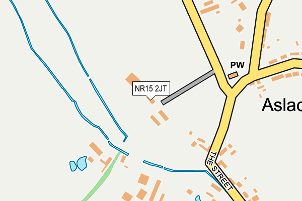
NR15 2JT lies on Steeple Lane in Aslacton, Norwich. NR15 2JT is located in the Bunwell electoral ward, within the local authority district of South Norfolk and the English Parliamentary constituency of South Norfolk. The Sub Integrated Care Board (ICB) Location is NHS Norfolk and Waveney ICB - 26A and the police force is Norfolk. This postcode has been in use since January 1980.


GetTheData
Source: OS OpenMap – Local (Ordnance Survey)
Source: OS VectorMap District (Ordnance Survey)
Licence: Open Government Licence (requires attribution)
| Easting | 615473 |
| Northing | 291043 |
| Latitude | 52.474784 |
| Longitude | 1.171283 |
GetTheData
Source: Open Postcode Geo
Licence: Open Government Licence
| Street | Steeple Lane |
| Locality | Aslacton |
| Town/City | Norwich |
| Country | England |
| Postcode District | NR15 |
➜ See where NR15 is on a map ➜ Where is Aslacton? | |
GetTheData
Source: Land Registry Price Paid Data
Licence: Open Government Licence
Elevation or altitude of NR15 2JT as distance above sea level:
| Metres | Feet | |
|---|---|---|
| Elevation | 40m | 131ft |
Elevation is measured from the approximate centre of the postcode, to the nearest point on an OS contour line from OS Terrain 50, which has contour spacing of ten vertical metres.
➜ How high above sea level am I? Find the elevation of your current position using your device's GPS.
GetTheData
Source: Open Postcode Elevation
Licence: Open Government Licence
| Ward | Bunwell |
| Constituency | South Norfolk |
GetTheData
Source: ONS Postcode Database
Licence: Open Government Licence
| Church Road (Muir Lane) | Aslacton | 636m |
| Church Road (Muir Lane) | Aslacton | 642m |
| Pottergate Bridge (Muir Lane) | Aslacton | 1,066m |
| Pottergate Bridge (Muir Lane) | Aslacton | 1,073m |
| Council Houses (Woodrow Lane) | Great Moulton | 1,333m |
GetTheData
Source: NaPTAN
Licence: Open Government Licence
| Percentage of properties with Next Generation Access | 100.0% |
| Percentage of properties with Superfast Broadband | 100.0% |
| Percentage of properties with Ultrafast Broadband | 0.0% |
| Percentage of properties with Full Fibre Broadband | 0.0% |
Superfast Broadband is between 30Mbps and 300Mbps
Ultrafast Broadband is > 300Mbps
| Percentage of properties unable to receive 2Mbps | 0.0% |
| Percentage of properties unable to receive 5Mbps | 0.0% |
| Percentage of properties unable to receive 10Mbps | 0.0% |
| Percentage of properties unable to receive 30Mbps | 0.0% |
GetTheData
Source: Ofcom
Licence: Ofcom Terms of Use (requires attribution)
GetTheData
Source: ONS Postcode Database
Licence: Open Government Licence


➜ Get more ratings from the Food Standards Agency
GetTheData
Source: Food Standards Agency
Licence: FSA terms & conditions
| Last Collection | |||
|---|---|---|---|
| Location | Mon-Fri | Sat | Distance |
| Pearl Farm | 12:00 | 09:00 | 397m |
| Low Common | 16:45 | 11:15 | 1,082m |
| Aslacton / The Rectory | 16:30 | 10:30 | 1,968m |
GetTheData
Source: Dracos
Licence: Creative Commons Attribution-ShareAlike
The below table lists the International Territorial Level (ITL) codes (formerly Nomenclature of Territorial Units for Statistics (NUTS) codes) and Local Administrative Units (LAU) codes for NR15 2JT:
| ITL 1 Code | Name |
|---|---|
| TLH | East |
| ITL 2 Code | Name |
| TLH1 | East Anglia |
| ITL 3 Code | Name |
| TLH17 | Breckland and South Norfolk |
| LAU 1 Code | Name |
| E07000149 | South Norfolk |
GetTheData
Source: ONS Postcode Directory
Licence: Open Government Licence
The below table lists the Census Output Area (OA), Lower Layer Super Output Area (LSOA), and Middle Layer Super Output Area (MSOA) for NR15 2JT:
| Code | Name | |
|---|---|---|
| OA | E00136706 | |
| LSOA | E01026877 | South Norfolk 011A |
| MSOA | E02005607 | South Norfolk 011 |
GetTheData
Source: ONS Postcode Directory
Licence: Open Government Licence
| NR15 2JW | The Street | 146m |
| NR15 2JP | The Street | 231m |
| NR15 2JH | Church Road | 353m |
| NR15 2JR | Wash Lane | 443m |
| NR15 2ES | Wash Lane | 656m |
| NR15 2JU | Pottergate Street | 751m |
| NR15 2ET | Mill Lane | 767m |
| NR15 2JE | Woodrow Lane | 847m |
| NR15 2JD | Mill Lane | 905m |
| NR15 2JB | Green Lane | 1040m |
GetTheData
Source: Open Postcode Geo; Land Registry Price Paid Data
Licence: Open Government Licence