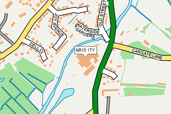
NR15 1TY is located in the Newton Flotman electoral ward, within the local authority district of South Norfolk and the English Parliamentary constituency of South Norfolk. The Sub Integrated Care Board (ICB) Location is NHS Norfolk and Waveney ICB - 26A and the police force is Norfolk. This postcode has been in use since January 1980.


GetTheData
Source: OS OpenMap – Local (Ordnance Survey)
Source: OS VectorMap District (Ordnance Survey)
Licence: Open Government Licence (requires attribution)
| Easting | 621175 |
| Northing | 297893 |
| Latitude | 52.533965 |
| Longitude | 1.259619 |
GetTheData
Source: Open Postcode Geo
Licence: Open Government Licence
| Country | England |
| Postcode District | NR15 |
➜ See where NR15 is on a map ➜ Where is Saxlingham Thorpe? | |
GetTheData
Source: Land Registry Price Paid Data
Licence: Open Government Licence
Elevation or altitude of NR15 1TY as distance above sea level:
| Metres | Feet | |
|---|---|---|
| Elevation | 20m | 66ft |
Elevation is measured from the approximate centre of the postcode, to the nearest point on an OS contour line from OS Terrain 50, which has contour spacing of ten vertical metres.
➜ How high above sea level am I? Find the elevation of your current position using your device's GPS.
GetTheData
Source: Open Postcode Elevation
Licence: Open Government Licence
| Ward | Newton Flotman |
| Constituency | South Norfolk |
GetTheData
Source: ONS Postcode Database
Licence: Open Government Licence
| Cargate Lane (Ipswich Road) | Newton Flotman | 178m |
| Alan Avenue (Flordon Road) | Newton Flotman | 229m |
| Alan Avenue (Flordon Road) | Newton Flotman | 238m |
| Mill Inn (Ipswich Road) | Saxlingham Thorpe | 305m |
| Mill Inn (Ipswich Road) | Saxlingham Thorpe | 351m |
GetTheData
Source: NaPTAN
Licence: Open Government Licence
GetTheData
Source: ONS Postcode Database
Licence: Open Government Licence


➜ Get more ratings from the Food Standards Agency
GetTheData
Source: Food Standards Agency
Licence: FSA terms & conditions
| Last Collection | |||
|---|---|---|---|
| Location | Mon-Fri | Sat | Distance |
| Hollysides Street | 15:10 | 07:55 | 2,416m |
| Ipswich Road / Nr Pulic House | 17:45 | 08:15 | 3,036m |
| Cuckoofield Lane | 16:30 | 09:30 | 3,043m |
GetTheData
Source: Dracos
Licence: Creative Commons Attribution-ShareAlike
The below table lists the International Territorial Level (ITL) codes (formerly Nomenclature of Territorial Units for Statistics (NUTS) codes) and Local Administrative Units (LAU) codes for NR15 1TY:
| ITL 1 Code | Name |
|---|---|
| TLH | East |
| ITL 2 Code | Name |
| TLH1 | East Anglia |
| ITL 3 Code | Name |
| TLH17 | Breckland and South Norfolk |
| LAU 1 Code | Name |
| E07000149 | South Norfolk |
GetTheData
Source: ONS Postcode Directory
Licence: Open Government Licence
The below table lists the Census Output Area (OA), Lower Layer Super Output Area (LSOA), and Middle Layer Super Output Area (MSOA) for NR15 1TY:
| Code | Name | |
|---|---|---|
| OA | E00137035 | |
| LSOA | E01026941 | South Norfolk 009F |
| MSOA | E02005605 | South Norfolk 009 |
GetTheData
Source: ONS Postcode Directory
Licence: Open Government Licence
| NR15 1TX | Ipswich Road | 91m |
| NR15 1UA | Kingsway | 108m |
| NR15 1PA | Waterside Gardens | 118m |
| NR15 1RD | Joy Avenue | 128m |
| NR15 1RE | Newton Close | 160m |
| NR15 1RG | Dell Close | 172m |
| NR15 1PD | Old Street | 190m |
| NR15 1RB | Higher Green Close | 233m |
| NR15 1PE | Short Street | 288m |
| NR15 1QY | Rosemary Cottages | 291m |
GetTheData
Source: Open Postcode Geo; Land Registry Price Paid Data
Licence: Open Government Licence