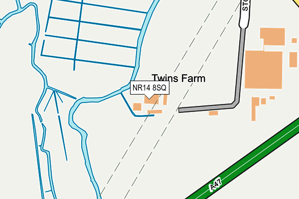
NR14 8SQ is located in the Poringland, Framinghams & Trowse electoral ward, within the local authority district of South Norfolk and the English Parliamentary constituency of South Norfolk. The Sub Integrated Care Board (ICB) Location is NHS Norfolk and Waveney ICB - 26A and the police force is Norfolk. This postcode has been in use since October 2016.


GetTheData
Source: OS OpenMap – Local (Ordnance Survey)
Source: OS VectorMap District (Ordnance Survey)
Licence: Open Government Licence (requires attribution)
| Easting | 623558 |
| Northing | 305346 |
| Latitude | 52.599908 |
| Longitude | 1.299736 |
GetTheData
Source: Open Postcode Geo
Licence: Open Government Licence
| Country | England |
| Postcode District | NR14 |
➜ See where NR14 is on a map | |
GetTheData
Source: Land Registry Price Paid Data
Licence: Open Government Licence
Elevation or altitude of NR14 8SQ as distance above sea level:
| Metres | Feet | |
|---|---|---|
| Elevation | 10m | 33ft |
Elevation is measured from the approximate centre of the postcode, to the nearest point on an OS contour line from OS Terrain 50, which has contour spacing of ten vertical metres.
➜ How high above sea level am I? Find the elevation of your current position using your device's GPS.
GetTheData
Source: Open Postcode Elevation
Licence: Open Government Licence
| Ward | Poringland, Framinghams & Trowse |
| Constituency | South Norfolk |
GetTheData
Source: ONS Postcode Database
Licence: Open Government Licence
| White Horse Lane (Stoke Rd) | Bixley | 362m |
| White Horse Lane (Stoke Rd) | Bixley | 374m |
| Anstell Road (Theobald Road) | Lakenham | 556m |
| Manthorpe Close (Sandy Lane) | Lakenham | 644m |
| Coleburn Road | Lakenham | 645m |
| Norwich Station | 3.1km |
GetTheData
Source: NaPTAN
Licence: Open Government Licence
GetTheData
Source: ONS Postcode Database
Licence: Open Government Licence


➜ Get more ratings from the Food Standards Agency
GetTheData
Source: Food Standards Agency
Licence: FSA terms & conditions
| Last Collection | |||
|---|---|---|---|
| Location | Mon-Fri | Sat | Distance |
| Old Lakenham Post Office | 17:00 | 11:00 | 633m |
| Locksley Road | 17:30 | 11:00 | 1,109m |
| Long John Hill | 17:45 | 11:00 | 1,169m |
GetTheData
Source: Dracos
Licence: Creative Commons Attribution-ShareAlike
The below table lists the International Territorial Level (ITL) codes (formerly Nomenclature of Territorial Units for Statistics (NUTS) codes) and Local Administrative Units (LAU) codes for NR14 8SQ:
| ITL 1 Code | Name |
|---|---|
| TLH | East |
| ITL 2 Code | Name |
| TLH1 | East Anglia |
| ITL 3 Code | Name |
| TLH17 | Breckland and South Norfolk |
| LAU 1 Code | Name |
| E07000149 | South Norfolk |
GetTheData
Source: ONS Postcode Directory
Licence: Open Government Licence
The below table lists the Census Output Area (OA), Lower Layer Super Output Area (LSOA), and Middle Layer Super Output Area (MSOA) for NR14 8SQ:
| Code | Name | |
|---|---|---|
| OA | E00137008 | |
| LSOA | E01026937 | South Norfolk 006G |
| MSOA | E02005602 | South Norfolk 006 |
GetTheData
Source: ONS Postcode Directory
Licence: Open Government Licence
| NR1 2NS | Coopers Lane | 540m |
| NR1 2NX | Theobald Road | 590m |
| NR1 2NT | Theobald Road | 616m |
| NR1 2NR | Sandy Lane | 626m |
| NR1 2NU | Astell Road | 629m |
| NR1 2NN | Sandy Lane | 639m |
| NR1 2NZ | Coleburn Road | 668m |
| NR1 2NY | Theobald Road | 674m |
| NR1 2NP | Manthorpe Close | 693m |
| NR1 2AB | Sandy Lane | 711m |
GetTheData
Source: Open Postcode Geo; Land Registry Price Paid Data
Licence: Open Government Licence