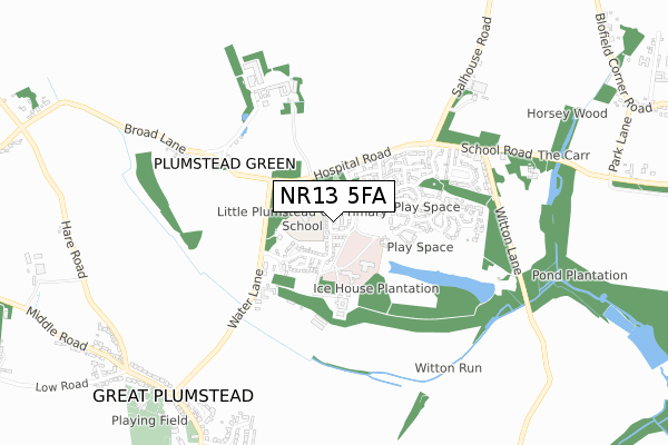
NR13 5FA is located in the Plumstead electoral ward, within the local authority district of Broadland and the English Parliamentary constituency of Broadland. The Sub Integrated Care Board (ICB) Location is NHS Norfolk and Waveney ICB - 26A and the police force is Norfolk. This postcode has been in use since January 2018.


GetTheData
Source: OS Open Zoomstack (Ordnance Survey)
Licence: Open Government Licence (requires attribution)
Attribution: Contains OS data © Crown copyright and database right 2024
Source: Open Postcode Geo
Licence: Open Government Licence (requires attribution)
Attribution: Contains OS data © Crown copyright and database right 2024; Contains Royal Mail data © Royal Mail copyright and database right 2024; Source: Office for National Statistics licensed under the Open Government Licence v.3.0
| Easting | 630712 |
| Northing | 310764 |
| Latitude | 52.645542 |
| Longitude | 1.408954 |
GetTheData
Source: Open Postcode Geo
Licence: Open Government Licence
| Country | England |
| Postcode District | NR13 |
➜ See where NR13 is on a map ➜ Where is Little Plumstead? | |
GetTheData
Source: Land Registry Price Paid Data
Licence: Open Government Licence
| Ward | Plumstead |
| Constituency | Broadland |
GetTheData
Source: ONS Postcode Database
Licence: Open Government Licence
| Hospital Road | Little Plumstead | 200m |
| Hospital Road | Little Plumstead | 210m |
| Old School (Church Road) | Great Plumstead | 892m |
| Old School (Church Road) | Great Plumstead | 898m |
| Stanford Crescent (Salhouse Road) | Little Plumstead | 1,567m |
| Brundall Gardens Station | 2.5km |
| Salhouse Station | 3.5km |
| Brundall Station | 3.6km |
GetTheData
Source: NaPTAN
Licence: Open Government Licence
| Percentage of properties with Next Generation Access | 100.0% |
| Percentage of properties with Superfast Broadband | 100.0% |
| Percentage of properties with Ultrafast Broadband | 100.0% |
| Percentage of properties with Full Fibre Broadband | 100.0% |
Superfast Broadband is between 30Mbps and 300Mbps
Ultrafast Broadband is > 300Mbps
| Percentage of properties unable to receive 2Mbps | 0.0% |
| Percentage of properties unable to receive 5Mbps | 0.0% |
| Percentage of properties unable to receive 10Mbps | 0.0% |
| Percentage of properties unable to receive 30Mbps | 0.0% |
GetTheData
Source: Ofcom
Licence: Ofcom Terms of Use (requires attribution)
GetTheData
Source: ONS Postcode Database
Licence: Open Government Licence


➜ Get more ratings from the Food Standards Agency
GetTheData
Source: Food Standards Agency
Licence: FSA terms & conditions
| Last Collection | |||
|---|---|---|---|
| Location | Mon-Fri | Sat | Distance |
| Lt Plumstead Post Office | 16:00 | 09:30 | 1,543m |
| Thorpe End Post Office | 16:45 | 11:35 | 2,712m |
| 116/118 The Street | 16:10 | 08:45 | 2,914m |
GetTheData
Source: Dracos
Licence: Creative Commons Attribution-ShareAlike
The below table lists the International Territorial Level (ITL) codes (formerly Nomenclature of Territorial Units for Statistics (NUTS) codes) and Local Administrative Units (LAU) codes for NR13 5FA:
| ITL 1 Code | Name |
|---|---|
| TLH | East |
| ITL 2 Code | Name |
| TLH1 | East Anglia |
| ITL 3 Code | Name |
| TLH15 | Norwich and East Norfolk |
| LAU 1 Code | Name |
| E07000144 | Broadland |
GetTheData
Source: ONS Postcode Directory
Licence: Open Government Licence
The below table lists the Census Output Area (OA), Lower Layer Super Output Area (LSOA), and Middle Layer Super Output Area (MSOA) for NR13 5FA:
| Code | Name | |
|---|---|---|
| OA | E00169824 | |
| LSOA | E01026545 | Broadland 008A |
| MSOA | E02005527 | Broadland 008 |
GetTheData
Source: ONS Postcode Directory
Licence: Open Government Licence
| NR13 5EW | Hospital Road | 118m |
| NR13 5FB | Kevill Davis Drive | 228m |
| NR13 5FF | Lakeland Close | 259m |
| NR13 5FE | Macmillan Way | 274m |
| NR13 5FJ | Beech Drive | 281m |
| NR13 5EX | Water Lane | 323m |
| NR13 5GA | Cozens Wiley Road | 337m |
| NR13 5EP | Copeman Road | 369m |
| NR13 5FG | Taylor Way | 409m |
| NR13 5FD | Morris Drive | 412m |
GetTheData
Source: Open Postcode Geo; Land Registry Price Paid Data
Licence: Open Government Licence