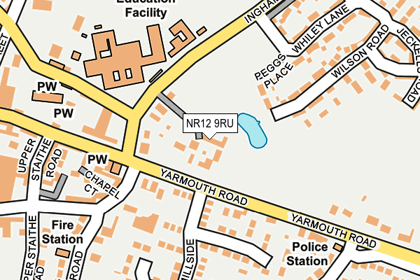
NR12 9RU lies on Church Farm Mews in Stalham, Norwich. NR12 9RU is located in the Stalham electoral ward, within the local authority district of North Norfolk and the English Parliamentary constituency of North Norfolk. The Sub Integrated Care Board (ICB) Location is NHS Norfolk and Waveney ICB - 26A and the police force is Norfolk. This postcode has been in use since September 2007.


GetTheData
Source: OS OpenMap – Local (Ordnance Survey)
Source: OS VectorMap District (Ordnance Survey)
Licence: Open Government Licence (requires attribution)
| Easting | 637546 |
| Northing | 325102 |
| Latitude | 52.771220 |
| Longitude | 1.520097 |
GetTheData
Source: Open Postcode Geo
Licence: Open Government Licence
| Street | Church Farm Mews |
| Locality | Stalham |
| Town/City | Norwich |
| Country | England |
| Postcode District | NR12 |
➜ See where NR12 is on a map ➜ Where is Stalham? | |
GetTheData
Source: Land Registry Price Paid Data
Licence: Open Government Licence
Elevation or altitude of NR12 9RU as distance above sea level:
| Metres | Feet | |
|---|---|---|
| Elevation | 10m | 33ft |
Elevation is measured from the approximate centre of the postcode, to the nearest point on an OS contour line from OS Terrain 50, which has contour spacing of ten vertical metres.
➜ How high above sea level am I? Find the elevation of your current position using your device's GPS.
GetTheData
Source: Open Postcode Elevation
Licence: Open Government Licence
| Ward | Stalham |
| Constituency | North Norfolk |
GetTheData
Source: ONS Postcode Database
Licence: Open Government Licence
| Millside (Yarmouth Road) | Stalham | 68m |
| Millside (Yarmouth Road) | Stalham | 83m |
| Garage (Ingham Road) | Stalham | 119m |
| Radio Shop (High Street) | Stalham | 158m |
| Tesco (A149) | Stalham | 464m |
GetTheData
Source: NaPTAN
Licence: Open Government Licence
| Percentage of properties with Next Generation Access | 0.0% |
| Percentage of properties with Superfast Broadband | 0.0% |
| Percentage of properties with Ultrafast Broadband | 0.0% |
| Percentage of properties with Full Fibre Broadband | 0.0% |
Superfast Broadband is between 30Mbps and 300Mbps
Ultrafast Broadband is > 300Mbps
| Median download speed | 23.3Mbps |
| Average download speed | 21.8Mbps |
| Maximum download speed | 24.38Mbps |
| Median upload speed | 1.3Mbps |
| Average upload speed | 1.1Mbps |
| Maximum upload speed | 1.28Mbps |
| Percentage of properties unable to receive 2Mbps | 0.0% |
| Percentage of properties unable to receive 5Mbps | 0.0% |
| Percentage of properties unable to receive 10Mbps | 0.0% |
| Percentage of properties unable to receive 30Mbps | 100.0% |
GetTheData
Source: Ofcom
Licence: Ofcom Terms of Use (requires attribution)
GetTheData
Source: ONS Postcode Database
Licence: Open Government Licence


➜ Get more ratings from the Food Standards Agency
GetTheData
Source: Food Standards Agency
Licence: FSA terms & conditions
| Last Collection | |||
|---|---|---|---|
| Location | Mon-Fri | Sat | Distance |
| Yarmouth Road Post Office | 16:50 | 09:20 | 261m |
| High Street Post Office | 17:15 | 12:30 | 430m |
| Staithe | 16:45 | 08:00 | 456m |
GetTheData
Source: Dracos
Licence: Creative Commons Attribution-ShareAlike
The below table lists the International Territorial Level (ITL) codes (formerly Nomenclature of Territorial Units for Statistics (NUTS) codes) and Local Administrative Units (LAU) codes for NR12 9RU:
| ITL 1 Code | Name |
|---|---|
| TLH | East |
| ITL 2 Code | Name |
| TLH1 | East Anglia |
| ITL 3 Code | Name |
| TLH16 | North and West Norfolk |
| LAU 1 Code | Name |
| E07000147 | North Norfolk |
GetTheData
Source: ONS Postcode Directory
Licence: Open Government Licence
The below table lists the Census Output Area (OA), Lower Layer Super Output Area (LSOA), and Middle Layer Super Output Area (MSOA) for NR12 9RU:
| Code | Name | |
|---|---|---|
| OA | E00136141 | |
| LSOA | E01026776 | North Norfolk 013C |
| MSOA | E02005582 | North Norfolk 013 |
GetTheData
Source: ONS Postcode Directory
Licence: Open Government Licence
| NR12 9PE | Yarmouth Road | 46m |
| NR12 9DJ | Ingham Road | 91m |
| NR12 9PD | Yarmouth Road | 104m |
| NR12 9FS | Peggs Place | 137m |
| NR12 9PF | Yarmouth Road | 145m |
| NR12 9PB | Millside | 168m |
| NR12 9GZ | Chapel Court | 182m |
| NR12 9AZ | High Street | 191m |
| NR12 9AE | Market Mews | 201m |
| NR12 9DH | Brumstead Road | 203m |
GetTheData
Source: Open Postcode Geo; Land Registry Price Paid Data
Licence: Open Government Licence