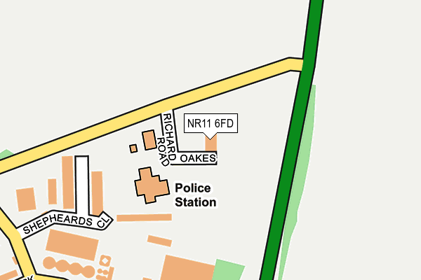
NR11 6FD is located in the Aylsham electoral ward, within the local authority district of Broadland and the English Parliamentary constituency of Broadland. The Sub Integrated Care Board (ICB) Location is NHS Norfolk and Waveney ICB - 26A and the police force is Norfolk. This postcode has been in use since October 2010.


GetTheData
Source: OS OpenMap – Local (Ordnance Survey)
Source: OS VectorMap District (Ordnance Survey)
Licence: Open Government Licence (requires attribution)
| Easting | 620509 |
| Northing | 327901 |
| Latitude | 52.803587 |
| Longitude | 1.269900 |
GetTheData
Source: Open Postcode Geo
Licence: Open Government Licence
| Country | England |
| Postcode District | NR11 |
➜ See where NR11 is on a map ➜ Where is Aylsham? | |
GetTheData
Source: Land Registry Price Paid Data
Licence: Open Government Licence
Elevation or altitude of NR11 6FD as distance above sea level:
| Metres | Feet | |
|---|---|---|
| Elevation | 20m | 66ft |
Elevation is measured from the approximate centre of the postcode, to the nearest point on an OS contour line from OS Terrain 50, which has contour spacing of ten vertical metres.
➜ How high above sea level am I? Find the elevation of your current position using your device's GPS.
GetTheData
Source: Open Postcode Elevation
Licence: Open Government Licence
| Ward | Aylsham |
| Constituency | Broadland |
GetTheData
Source: ONS Postcode Database
Licence: Open Government Licence
| Dunkirk (Millgate) | Aylsham | 747m |
| Dunkirk (Millgate) | Aylsham | 790m |
| Mill Row (Millgate) | Aylsham | 1,010m |
| Mill Row (Millgate) | Aylsham | 1,022m |
| High School (Sir William's Lane) | Aylsham | 1,088m |
| Aylsham (Bure Valley Railway) | Aylsham | 1,696m |
GetTheData
Source: NaPTAN
Licence: Open Government Licence
GetTheData
Source: ONS Postcode Database
Licence: Open Government Licence


➜ Get more ratings from the Food Standards Agency
GetTheData
Source: Food Standards Agency
Licence: FSA terms & conditions
| Last Collection | |||
|---|---|---|---|
| Location | Mon-Fri | Sat | Distance |
| Dunkirk | 16:00 | 08:30 | 569m |
| Cromer Road | 17:00 | 09:30 | 1,343m |
| Tesco Stores | 17:00 | 07:00 | 1,761m |
GetTheData
Source: Dracos
Licence: Creative Commons Attribution-ShareAlike
The below table lists the International Territorial Level (ITL) codes (formerly Nomenclature of Territorial Units for Statistics (NUTS) codes) and Local Administrative Units (LAU) codes for NR11 6FD:
| ITL 1 Code | Name |
|---|---|
| TLH | East |
| ITL 2 Code | Name |
| TLH1 | East Anglia |
| ITL 3 Code | Name |
| TLH15 | Norwich and East Norfolk |
| LAU 1 Code | Name |
| E07000144 | Broadland |
GetTheData
Source: ONS Postcode Directory
Licence: Open Government Licence
The below table lists the Census Output Area (OA), Lower Layer Super Output Area (LSOA), and Middle Layer Super Output Area (MSOA) for NR11 6FD:
| Code | Name | |
|---|---|---|
| OA | E00134667 | |
| LSOA | E01026503 | Broadland 001E |
| MSOA | E02005520 | Broadland 001 |
GetTheData
Source: ONS Postcode Directory
Licence: Open Government Licence
| NR11 6LP | Banningham Road | 511m |
| NR11 6SU | Dunkirk | 586m |
| NR11 6LR | Drabblegate | 593m |
| NR11 6TA | Tuttington Road | 604m |
| NR11 6SX | Wherry Loke | 722m |
| NR11 6UY | The Staithe | 767m |
| NR11 6ST | Mashs Row | 810m |
| NR11 6HZ | Mill Row | 865m |
| NR11 6LS | Banningham Road | 870m |
| NR11 6GX | The Maltings | 991m |
GetTheData
Source: Open Postcode Geo; Land Registry Price Paid Data
Licence: Open Government Licence