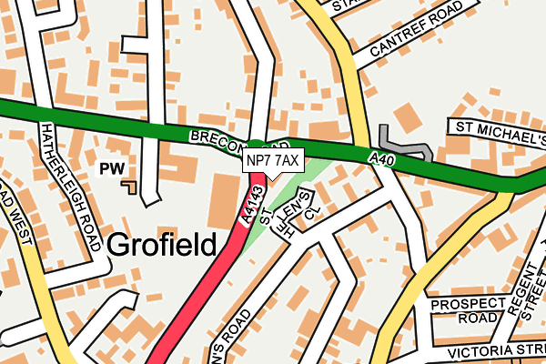
NP7 7AX is located in the Grofield electoral ward, within the unitary authority of Monmouthshire and the Welsh Parliamentary constituency of Monmouth. The Local Health Board is Aneurin Bevan University and the police force is Gwent. This postcode has been in use since August 1993.


GetTheData
Source: OS OpenMap – Local (Ordnance Survey)
Source: OS VectorMap District (Ordnance Survey)
Licence: Open Government Licence (requires attribution)
| Easting | 329307 |
| Northing | 214513 |
| Latitude | 51.824746 |
| Longitude | -3.027137 |
GetTheData
Source: Open Postcode Geo
Licence: Open Government Licence
| Country | Wales |
| Postcode District | NP7 |
➜ See where NP7 is on a map ➜ Where is Abergavenny? | |
GetTheData
Source: Land Registry Price Paid Data
Licence: Open Government Licence
Elevation or altitude of NP7 7AX as distance above sea level:
| Metres | Feet | |
|---|---|---|
| Elevation | 60m | 197ft |
Elevation is measured from the approximate centre of the postcode, to the nearest point on an OS contour line from OS Terrain 50, which has contour spacing of ten vertical metres.
➜ How high above sea level am I? Find the elevation of your current position using your device's GPS.
GetTheData
Source: Open Postcode Elevation
Licence: Open Government Licence
| Ward | Grofield |
| Constituency | Monmouth |
GetTheData
Source: ONS Postcode Database
Licence: Open Government Licence
| Brecon Road Surgery (Brecon Road) | Abergavenny | 84m |
| Brecon Road Surgery (Brecon Road) | Abergavenny | 87m |
| The Gables (Chapel Road) | Abergavenny | 294m |
| The Gables (Chapel Road) | Abergavenny | 300m |
| Penypound Church (Pen-y-pond) | Abergavenny | 415m |
| Abergavenny Station | 1.5km |
GetTheData
Source: NaPTAN
Licence: Open Government Licence
GetTheData
Source: ONS Postcode Database
Licence: Open Government Licence


➜ Get more ratings from the Food Standards Agency
GetTheData
Source: Food Standards Agency
Licence: FSA terms & conditions
| Last Collection | |||
|---|---|---|---|
| Location | Mon-Fri | Sat | Distance |
| Frogmore Street Post Office | 17:00 | 11:00 | 414m |
| Pant Y Goitre | 16:15 | 10:00 | 415m |
| Cross Street | 17:15 | 11:15 | 855m |
GetTheData
Source: Dracos
Licence: Creative Commons Attribution-ShareAlike
The below table lists the International Territorial Level (ITL) codes (formerly Nomenclature of Territorial Units for Statistics (NUTS) codes) and Local Administrative Units (LAU) codes for NP7 7AX:
| ITL 1 Code | Name |
|---|---|
| TLL | Wales |
| ITL 2 Code | Name |
| TLL2 | East Wales |
| ITL 3 Code | Name |
| TLL21 | Monmouthshire and Newport |
| LAU 1 Code | Name |
| W06000021 | Monmouthshire |
GetTheData
Source: ONS Postcode Directory
Licence: Open Government Licence
The below table lists the Census Output Area (OA), Lower Layer Super Output Area (LSOA), and Middle Layer Super Output Area (MSOA) for NP7 7AX:
| Code | Name | |
|---|---|---|
| OA | W00008116 | |
| LSOA | W01001557 | Monmouthshire 001C |
| MSOA | W02000336 | Monmouthshire 001 |
GetTheData
Source: ONS Postcode Directory
Licence: Open Government Licence
| NP7 5UZ | St Helens Close | 59m |
| NP7 7RA | Brecon Road | 66m |
| NP7 5UY | St Helens Road | 111m |
| NP7 5UF | Orchard Mews | 114m |
| NP7 5YB | Park Street | 145m |
| NP7 7DT | Mount Street | 152m |
| NP7 5DY | Commercial Street | 157m |
| NP7 7RB | Brecon Road | 158m |
| NP7 7DN | Chapel Road | 158m |
| NP7 5DD | Lamb Close | 160m |
GetTheData
Source: Open Postcode Geo; Land Registry Price Paid Data
Licence: Open Government Licence