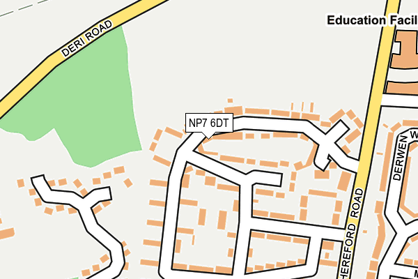
NP7 6DT lies on Underhill Crescent in Abergavenny. NP7 6DT is located in the Lansdown electoral ward, within the unitary authority of Monmouthshire and the Welsh Parliamentary constituency of Monmouth. The Local Health Board is Aneurin Bevan University and the police force is Gwent. This postcode has been in use since January 1980.


GetTheData
Source: OS OpenMap – Local (Ordnance Survey)
Source: OS VectorMap District (Ordnance Survey)
Licence: Open Government Licence (requires attribution)
| Easting | 329852 |
| Northing | 215555 |
| Latitude | 51.834187 |
| Longitude | -3.019449 |
GetTheData
Source: Open Postcode Geo
Licence: Open Government Licence
| Street | Underhill Crescent |
| Town/City | Abergavenny |
| Country | Wales |
| Postcode District | NP7 |
➜ See where NP7 is on a map ➜ Where is Abergavenny? | |
GetTheData
Source: Land Registry Price Paid Data
Licence: Open Government Licence
Elevation or altitude of NP7 6DT as distance above sea level:
| Metres | Feet | |
|---|---|---|
| Elevation | 120m | 394ft |
Elevation is measured from the approximate centre of the postcode, to the nearest point on an OS contour line from OS Terrain 50, which has contour spacing of ten vertical metres.
➜ How high above sea level am I? Find the elevation of your current position using your device's GPS.
GetTheData
Source: Open Postcode Elevation
Licence: Open Government Licence
| Ward | Lansdown |
| Constituency | Monmouth |
GetTheData
Source: ONS Postcode Database
Licence: Open Government Licence
| Underhill Crescent (Underhill Cresent) | Abergavenny | 68m |
| Underhill Crescent | Abergavenny | 118m |
| Rother Avenue (Underhill Crescent) | Abergavenny | 221m |
| Meadway (Old Barn Way) | Abergavenny | 302m |
| King Henry Viii School (Grounds) | Abergavenny | 340m |
| Abergavenny Station | 2.1km |
GetTheData
Source: NaPTAN
Licence: Open Government Licence
| Percentage of properties with Next Generation Access | 100.0% |
| Percentage of properties with Superfast Broadband | 100.0% |
| Percentage of properties with Ultrafast Broadband | 0.0% |
| Percentage of properties with Full Fibre Broadband | 0.0% |
Superfast Broadband is between 30Mbps and 300Mbps
Ultrafast Broadband is > 300Mbps
| Median download speed | 39.1Mbps |
| Average download speed | 28.5Mbps |
| Maximum download speed | 77.13Mbps |
| Median upload speed | 6.7Mbps |
| Average upload speed | 6.3Mbps |
| Maximum upload speed | 20.00Mbps |
| Percentage of properties unable to receive 2Mbps | 0.0% |
| Percentage of properties unable to receive 5Mbps | 0.0% |
| Percentage of properties unable to receive 10Mbps | 0.0% |
| Percentage of properties unable to receive 30Mbps | 0.0% |
GetTheData
Source: Ofcom
Licence: Ofcom Terms of Use (requires attribution)
Estimated total energy consumption in NP7 6DT by fuel type, 2015.
| Consumption (kWh) | 355,403 |
|---|---|
| Meter count | 39 |
| Mean (kWh/meter) | 9,113 |
| Median (kWh/meter) | 8,724 |
| Consumption (kWh) | 134,844 |
|---|---|
| Meter count | 36 |
| Mean (kWh/meter) | 3,746 |
| Median (kWh/meter) | 3,131 |
GetTheData
Source: Postcode level gas estimates: 2015 (experimental)
Source: Postcode level electricity estimates: 2015 (experimental)
Licence: Open Government Licence
GetTheData
Source: ONS Postcode Database
Licence: Open Government Licence


➜ Get more ratings from the Food Standards Agency
GetTheData
Source: Food Standards Agency
Licence: FSA terms & conditions
| Last Collection | |||
|---|---|---|---|
| Location | Mon-Fri | Sat | Distance |
| Pant Y Goitre | 16:15 | 10:00 | 975m |
| Frogmore Street Post Office | 17:00 | 11:00 | 1,079m |
| Cross Street | 17:15 | 11:15 | 1,521m |
GetTheData
Source: Dracos
Licence: Creative Commons Attribution-ShareAlike
The below table lists the International Territorial Level (ITL) codes (formerly Nomenclature of Territorial Units for Statistics (NUTS) codes) and Local Administrative Units (LAU) codes for NP7 6DT:
| ITL 1 Code | Name |
|---|---|
| TLL | Wales |
| ITL 2 Code | Name |
| TLL2 | East Wales |
| ITL 3 Code | Name |
| TLL21 | Monmouthshire and Newport |
| LAU 1 Code | Name |
| W06000021 | Monmouthshire |
GetTheData
Source: ONS Postcode Directory
Licence: Open Government Licence
The below table lists the Census Output Area (OA), Lower Layer Super Output Area (LSOA), and Middle Layer Super Output Area (MSOA) for NP7 6DT:
| Code | Name | |
|---|---|---|
| OA | W00008059 | |
| LSOA | W01001546 | Monmouthshire 002A |
| MSOA | W02000337 | Monmouthshire 002 |
GetTheData
Source: ONS Postcode Directory
Licence: Open Government Licence
| NP7 6DE | Rother Avenue | 63m |
| NP7 6DR | Underhill Crescent | 95m |
| NP7 6DP | Underhill Crescent | 96m |
| NP7 6DW | Majors Close | 146m |
| NP7 6DU | Underhill Crescent | 154m |
| NP7 6DD | Rother Avenue | 159m |
| NP7 6DN | Underhill Crescent | 169m |
| NP7 6DB | Rother Avenue | 186m |
| NP7 6DH | Underhill Crescent | 196m |
| NP7 6DG | Underhill Crescent | 216m |
GetTheData
Source: Open Postcode Geo; Land Registry Price Paid Data
Licence: Open Government Licence