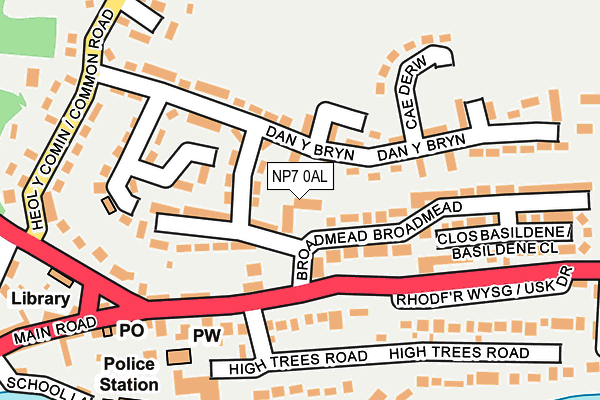
NP7 0AL lies on Llanwenarth View in Gilwern, Abergavenny. NP7 0AL is located in the Llanelly electoral ward, within the unitary authority of Monmouthshire and the Welsh Parliamentary constituency of Monmouth. The Local Health Board is Aneurin Bevan University and the police force is Gwent. This postcode has been in use since January 1980.


GetTheData
Source: OS OpenMap – Local (Ordnance Survey)
Source: OS VectorMap District (Ordnance Survey)
Licence: Open Government Licence (requires attribution)
| Easting | 324932 |
| Northing | 214733 |
| Latitude | 51.826152 |
| Longitude | -3.090653 |
GetTheData
Source: Open Postcode Geo
Licence: Open Government Licence
| Street | Llanwenarth View |
| Locality | Gilwern |
| Town/City | Abergavenny |
| Country | Wales |
| Postcode District | NP7 |
➜ See where NP7 is on a map ➜ Where is Gilwern? | |
GetTheData
Source: Land Registry Price Paid Data
Licence: Open Government Licence
Elevation or altitude of NP7 0AL as distance above sea level:
| Metres | Feet | |
|---|---|---|
| Elevation | 90m | 295ft |
Elevation is measured from the approximate centre of the postcode, to the nearest point on an OS contour line from OS Terrain 50, which has contour spacing of ten vertical metres.
➜ How high above sea level am I? Find the elevation of your current position using your device's GPS.
GetTheData
Source: Open Postcode Elevation
Licence: Open Government Licence
| Ward | Llanelly |
| Constituency | Monmouth |
GetTheData
Source: ONS Postcode Database
Licence: Open Government Licence
| Rectory (Abergavenny Road) | Gilwern | 91m |
| Rectory (Abergavenny Road) | Gilwern | 114m |
| Post Office (Crickhowell Road) | Gilwern | 199m |
| Post Office (Main Road) | Gilwern | 237m |
| Corn Exchange (Crickhowell Road) | Gilwern | 368m |
GetTheData
Source: NaPTAN
Licence: Open Government Licence
Estimated total energy consumption in NP7 0AL by fuel type, 2015.
| Consumption (kWh) | 65,434 |
|---|---|
| Meter count | 9 |
| Mean (kWh/meter) | 7,270 |
| Median (kWh/meter) | 7,941 |
| Consumption (kWh) | 11,771 |
|---|---|
| Meter count | 7 |
| Mean (kWh/meter) | 1,682 |
| Median (kWh/meter) | 1,664 |
GetTheData
Source: Postcode level gas estimates: 2015 (experimental)
Source: Postcode level electricity estimates: 2015 (experimental)
Licence: Open Government Licence
GetTheData
Source: ONS Postcode Database
Licence: Open Government Licence


➜ Get more ratings from the Food Standards Agency
GetTheData
Source: Food Standards Agency
Licence: FSA terms & conditions
| Last Collection | |||
|---|---|---|---|
| Location | Mon-Fri | Sat | Distance |
| Llangattock Lingoed | 16:00 | 09:00 | 1,884m |
| Llangenny | 17:00 | 08:00 | 3,407m |
| Llangenny Lane | 17:00 | 11:00 | 4,461m |
GetTheData
Source: Dracos
Licence: Creative Commons Attribution-ShareAlike
The below table lists the International Territorial Level (ITL) codes (formerly Nomenclature of Territorial Units for Statistics (NUTS) codes) and Local Administrative Units (LAU) codes for NP7 0AL:
| ITL 1 Code | Name |
|---|---|
| TLL | Wales |
| ITL 2 Code | Name |
| TLL2 | East Wales |
| ITL 3 Code | Name |
| TLL21 | Monmouthshire and Newport |
| LAU 1 Code | Name |
| W06000021 | Monmouthshire |
GetTheData
Source: ONS Postcode Directory
Licence: Open Government Licence
The below table lists the Census Output Area (OA), Lower Layer Super Output Area (LSOA), and Middle Layer Super Output Area (MSOA) for NP7 0AL:
| Code | Name | |
|---|---|---|
| OA | W00008146 | |
| LSOA | W01001563 | Monmouthshire 003C |
| MSOA | W02000338 | Monmouthshire 003 |
GetTheData
Source: ONS Postcode Directory
Licence: Open Government Licence
| NP7 0BW | Brynglas | 74m |
| NP7 0AN | Broadmead | 117m |
| NP7 0AD | Abergavenny Road | 118m |
| NP7 0BP | Brynglas | 134m |
| NP7 0AJ | Hightrees Court | 139m |
| NP7 0DU | Glanrhyd | 143m |
| NP7 0BL | Dan Y Bryn | 147m |
| NP7 0AP | Main Road | 151m |
| NP7 0BN | Brynglas | 168m |
| NP7 0BJ | Cae Derw | 186m |
GetTheData
Source: Open Postcode Geo; Land Registry Price Paid Data
Licence: Open Government Licence