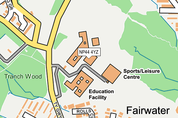
NP44 4YZ is located in the Fairwater electoral ward, within the unitary authority of Torfaen and the Welsh Parliamentary constituency of Torfaen. The Local Health Board is Aneurin Bevan University and the police force is Gwent. This postcode has been in use since March 1983.


GetTheData
Source: OS OpenMap – Local (Ordnance Survey)
Source: OS VectorMap District (Ordnance Survey)
Licence: Open Government Licence (requires attribution)
| Easting | 327352 |
| Northing | 194850 |
| Latitude | 51.647732 |
| Longitude | -3.051387 |
GetTheData
Source: Open Postcode Geo
Licence: Open Government Licence
| Country | Wales |
| Postcode District | NP44 |
➜ See where NP44 is on a map ➜ Where is Cwmbrân? | |
GetTheData
Source: Land Registry Price Paid Data
Licence: Open Government Licence
Elevation or altitude of NP44 4YZ as distance above sea level:
| Metres | Feet | |
|---|---|---|
| Elevation | 130m | 427ft |
Elevation is measured from the approximate centre of the postcode, to the nearest point on an OS contour line from OS Terrain 50, which has contour spacing of ten vertical metres.
➜ How high above sea level am I? Find the elevation of your current position using your device's GPS.
GetTheData
Source: Open Postcode Elevation
Licence: Open Government Licence
| Ward | Fairwater |
| Constituency | Torfaen |
GetTheData
Source: ONS Postcode Database
Licence: Open Government Licence
| Comprehensive School (Ty Gwyn Way) | Fairwater | 137m |
| Comprehensive School (Ty Gwyn Way) | Fairwater | 181m |
| Brunel Road (Ty Gwyn Way) | Fairwater | 230m |
| Pumping Station (Ty Canol Way) | Thornhill | 278m |
| Brunel Road (Ty Gwyn Way) | Fairwater | 281m |
| Cwmbran Station | 2.6km |
| Risca & Pontymister Station | 5.4km |
GetTheData
Source: NaPTAN
Licence: Open Government Licence
GetTheData
Source: ONS Postcode Database
Licence: Open Government Licence


➜ Get more ratings from the Food Standards Agency
GetTheData
Source: Food Standards Agency
Licence: FSA terms & conditions
| Last Collection | |||
|---|---|---|---|
| Location | Mon-Fri | Sat | Distance |
| Radnor Way | 17:30 | 11:00 | 2,040m |
| Five Locks Close | 17:30 | 11:00 | 2,324m |
| Llantarnam Road | 17:30 | 11:00 | 2,508m |
GetTheData
Source: Dracos
Licence: Creative Commons Attribution-ShareAlike
The below table lists the International Territorial Level (ITL) codes (formerly Nomenclature of Territorial Units for Statistics (NUTS) codes) and Local Administrative Units (LAU) codes for NP44 4YZ:
| ITL 1 Code | Name |
|---|---|
| TLL | Wales |
| ITL 2 Code | Name |
| TLL1 | West Wales and The Valleys |
| ITL 3 Code | Name |
| TLL16 | Gwent Valleys |
| LAU 1 Code | Name |
| W06000020 | Torfaen |
GetTheData
Source: ONS Postcode Directory
Licence: Open Government Licence
The below table lists the Census Output Area (OA), Lower Layer Super Output Area (LSOA), and Middle Layer Super Output Area (MSOA) for NP44 4YZ:
| Code | Name | |
|---|---|---|
| OA | W00007822 | |
| LSOA | W01001497 | Torfaen 011A |
| MSOA | W02000333 | Torfaen 011 |
GetTheData
Source: ONS Postcode Directory
Licence: Open Government Licence
| NP44 4QU | Rolls Close | 191m |
| NP44 4QX | Ruskin Close | 225m |
| NP44 6UP | Oaksford | 236m |
| NP44 4QT | Brunel Road | 279m |
| NP44 6UQ | Oaksford | 315m |
| NP44 4ST | The Twinings | 319m |
| NP44 4SU | Littledene | 329m |
| NP44 4SX | Deer Brook | 329m |
| NP44 5HL | York Close | 348m |
| NP44 5EB | Spring Grove | 357m |
GetTheData
Source: Open Postcode Geo; Land Registry Price Paid Data
Licence: Open Government Licence