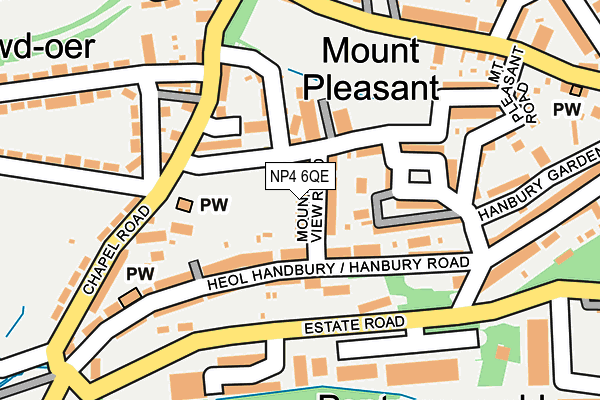
NP4 6QE lies on Bryn Terrace in Pontnewynydd, Pontypool. NP4 6QE is located in the Pontnewynydd and Snatchwood electoral ward, within the unitary authority of Torfaen and the Welsh Parliamentary constituency of Torfaen. The Local Health Board is Aneurin Bevan University and the police force is Gwent. This postcode has been in use since January 1980.


GetTheData
Source: OS OpenMap – Local (Ordnance Survey)
Source: OS VectorMap District (Ordnance Survey)
Licence: Open Government Licence (requires attribution)
| Easting | 326895 |
| Northing | 201817 |
| Latitude | 51.710304 |
| Longitude | -3.059452 |
GetTheData
Source: Open Postcode Geo
Licence: Open Government Licence
| Street | Bryn Terrace |
| Locality | Pontnewynydd |
| Town/City | Pontypool |
| Country | Wales |
| Postcode District | NP4 |
➜ See where NP4 is on a map ➜ Where is Pontypool? | |
GetTheData
Source: Land Registry Price Paid Data
Licence: Open Government Licence
Elevation or altitude of NP4 6QE as distance above sea level:
| Metres | Feet | |
|---|---|---|
| Elevation | 180m | 591ft |
Elevation is measured from the approximate centre of the postcode, to the nearest point on an OS contour line from OS Terrain 50, which has contour spacing of ten vertical metres.
➜ How high above sea level am I? Find the elevation of your current position using your device's GPS.
GetTheData
Source: Open Postcode Elevation
Licence: Open Government Licence
| Ward | Pontnewynydd And Snatchwood |
| Constituency | Torfaen |
GetTheData
Source: ONS Postcode Database
Licence: Open Government Licence
| Forgehammer (Hanbury Road) | Pontnewynydd | 178m |
| Forgehammer (Hanbury Road) | Pontnewynydd | 178m |
| Estate Road | Cwmffrwdoer | 180m |
| Estate Road | Cwmffrwdoer | 187m |
| Waunddu | Cwmffrwdoer | 204m |
| Pontypool & New Inn Station | 3.4km |
GetTheData
Source: NaPTAN
Licence: Open Government Licence
| Percentage of properties with Next Generation Access | 100.0% |
| Percentage of properties with Superfast Broadband | 100.0% |
| Percentage of properties with Ultrafast Broadband | 100.0% |
| Percentage of properties with Full Fibre Broadband | 0.0% |
Superfast Broadband is between 30Mbps and 300Mbps
Ultrafast Broadband is > 300Mbps
| Median download speed | 46.0Mbps |
| Average download speed | 37.3Mbps |
| Maximum download speed | 77.88Mbps |
| Median upload speed | 15.7Mbps |
| Average upload speed | 11.7Mbps |
| Maximum upload speed | 20.00Mbps |
| Percentage of properties unable to receive 2Mbps | 0.0% |
| Percentage of properties unable to receive 5Mbps | 0.0% |
| Percentage of properties unable to receive 10Mbps | 0.0% |
| Percentage of properties unable to receive 30Mbps | 0.0% |
GetTheData
Source: Ofcom
Licence: Ofcom Terms of Use (requires attribution)
Estimated total energy consumption in NP4 6QE by fuel type, 2015.
| Consumption (kWh) | 248,703 |
|---|---|
| Meter count | 16 |
| Mean (kWh/meter) | 15,544 |
| Median (kWh/meter) | 15,762 |
| Consumption (kWh) | 55,682 |
|---|---|
| Meter count | 15 |
| Mean (kWh/meter) | 3,712 |
| Median (kWh/meter) | 3,589 |
GetTheData
Source: Postcode level gas estimates: 2015 (experimental)
Source: Postcode level electricity estimates: 2015 (experimental)
Licence: Open Government Licence
GetTheData
Source: ONS Postcode Database
Licence: Open Government Licence


➜ Get more ratings from the Food Standards Agency
GetTheData
Source: Food Standards Agency
Licence: FSA terms & conditions
| Last Collection | |||
|---|---|---|---|
| Location | Mon-Fri | Sat | Distance |
| Penygarn Post Office | 16:00 | 11:15 | 1,265m |
| Garn Yr Erw | 11:30 | 10:00 | 2,056m |
| Forgeside Post Office | 16:45 | 11:45 | 2,056m |
GetTheData
Source: Dracos
Licence: Creative Commons Attribution-ShareAlike
The below table lists the International Territorial Level (ITL) codes (formerly Nomenclature of Territorial Units for Statistics (NUTS) codes) and Local Administrative Units (LAU) codes for NP4 6QE:
| ITL 1 Code | Name |
|---|---|
| TLL | Wales |
| ITL 2 Code | Name |
| TLL1 | West Wales and The Valleys |
| ITL 3 Code | Name |
| TLL16 | Gwent Valleys |
| LAU 1 Code | Name |
| W06000020 | Torfaen |
GetTheData
Source: ONS Postcode Directory
Licence: Open Government Licence
The below table lists the Census Output Area (OA), Lower Layer Super Output Area (LSOA), and Middle Layer Super Output Area (MSOA) for NP4 6QE:
| Code | Name | |
|---|---|---|
| OA | W00007952 | |
| LSOA | W01001523 | Torfaen 004C |
| MSOA | W02000326 | Torfaen 004 |
GetTheData
Source: ONS Postcode Directory
Licence: Open Government Licence
| NP4 6QF | Mountain View | 34m |
| NP4 6QG | Coronation Terrace | 53m |
| NP4 6PN | Baileys Terrace | 62m |
| NP4 6PX | Wellwood Cottages | 72m |
| NP4 6PW | Pleasant View | 83m |
| NP4 6PT | Park View Terrace | 84m |
| NP4 6PZ | School Terrace | 85m |
| NP4 6PS | Beech Tree Terrace | 90m |
| NP4 6PR | Oakdale Place | 91m |
| NP4 6QQ | Hanbury Road | 97m |
GetTheData
Source: Open Postcode Geo; Land Registry Price Paid Data
Licence: Open Government Licence