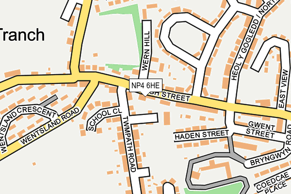
NP4 6HE lies on High Street in Pontypool. NP4 6HE is located in the Pontypool Fawr electoral ward, within the unitary authority of Torfaen and the Welsh Parliamentary constituency of Torfaen. The Local Health Board is Aneurin Bevan University and the police force is Gwent. This postcode has been in use since January 1980.


GetTheData
Source: OS OpenMap – Local (Ordnance Survey)
Source: OS VectorMap District (Ordnance Survey)
Licence: Open Government Licence (requires attribution)
| Easting | 327616 |
| Northing | 200739 |
| Latitude | 51.700707 |
| Longitude | -3.048795 |
GetTheData
Source: Open Postcode Geo
Licence: Open Government Licence
| Street | High Street |
| Town/City | Pontypool |
| Country | Wales |
| Postcode District | NP4 |
➜ See where NP4 is on a map ➜ Where is Pontypool? | |
GetTheData
Source: Land Registry Price Paid Data
Licence: Open Government Licence
Elevation or altitude of NP4 6HE as distance above sea level:
| Metres | Feet | |
|---|---|---|
| Elevation | 190m | 623ft |
Elevation is measured from the approximate centre of the postcode, to the nearest point on an OS contour line from OS Terrain 50, which has contour spacing of ten vertical metres.
➜ How high above sea level am I? Find the elevation of your current position using your device's GPS.
GetTheData
Source: Open Postcode Elevation
Licence: Open Government Licence
| Ward | Pontypool Fawr |
| Constituency | Torfaen |
GetTheData
Source: ONS Postcode Database
Licence: Open Government Licence
PORTHMEOR BUNGALOW, HIGH STREET, PONTYPOOL, NP4 6HE 2002 4 NOV £135,000 |
2002 18 JAN £72,500 |
1996 4 APR £42,500 |
GetTheData
Source: HM Land Registry Price Paid Data
Licence: Contains HM Land Registry data © Crown copyright and database right 2024. This data is licensed under the Open Government Licence v3.0.
| Labour In Vain (High Street) | Tranch | 23m |
| St Dominic`s Retreat (Twmpath Road) | Tranch | 46m |
| St Dominic`s Retreat (Twmpath Road) | Tranch | 53m |
| Coles Shop (Tranch Road) | Tranch | 107m |
| Sunnyside (Tranch Road) | Tranch | 132m |
| Pontypool & New Inn Station | 2.4km |
| Cwmbran Station | 5.4km |
GetTheData
Source: NaPTAN
Licence: Open Government Licence
| Percentage of properties with Next Generation Access | 100.0% |
| Percentage of properties with Superfast Broadband | 100.0% |
| Percentage of properties with Ultrafast Broadband | 0.0% |
| Percentage of properties with Full Fibre Broadband | 0.0% |
Superfast Broadband is between 30Mbps and 300Mbps
Ultrafast Broadband is > 300Mbps
| Percentage of properties unable to receive 2Mbps | 0.0% |
| Percentage of properties unable to receive 5Mbps | 0.0% |
| Percentage of properties unable to receive 10Mbps | 0.0% |
| Percentage of properties unable to receive 30Mbps | 0.0% |
GetTheData
Source: Ofcom
Licence: Ofcom Terms of Use (requires attribution)
GetTheData
Source: ONS Postcode Database
Licence: Open Government Licence


➜ Get more ratings from the Food Standards Agency
GetTheData
Source: Food Standards Agency
Licence: FSA terms & conditions
| Last Collection | |||
|---|---|---|---|
| Location | Mon-Fri | Sat | Distance |
| Garn Yr Erw | 11:30 | 10:00 | 961m |
| Forgeside Post Office | 16:45 | 11:45 | 961m |
| Penygarn Post Office | 16:00 | 11:15 | 1,716m |
GetTheData
Source: Dracos
Licence: Creative Commons Attribution-ShareAlike
The below table lists the International Territorial Level (ITL) codes (formerly Nomenclature of Territorial Units for Statistics (NUTS) codes) and Local Administrative Units (LAU) codes for NP4 6HE:
| ITL 1 Code | Name |
|---|---|
| TLL | Wales |
| ITL 2 Code | Name |
| TLL1 | West Wales and The Valleys |
| ITL 3 Code | Name |
| TLL16 | Gwent Valleys |
| LAU 1 Code | Name |
| W06000020 | Torfaen |
GetTheData
Source: ONS Postcode Directory
Licence: Open Government Licence
The below table lists the Census Output Area (OA), Lower Layer Super Output Area (LSOA), and Middle Layer Super Output Area (MSOA) for NP4 6HE:
| Code | Name | |
|---|---|---|
| OA | W00007790 | |
| LSOA | W01001491 | Torfaen 004A |
| MSOA | W02000326 | Torfaen 004 |
GetTheData
Source: ONS Postcode Directory
Licence: Open Government Licence
| NP4 6AF | St Dominics Retreat | 36m |
| NP4 6HF | Brynwern | 73m |
| NP4 6AQ | Twmpath Road | 102m |
| NP4 6HA | Wern Terrace | 107m |
| NP4 6EU | Haden Street | 118m |
| NP4 6AN | Tranch Road | 122m |
| NP4 6HJ | Brynwern | 167m |
| NP4 6AX | Penywain Lane | 183m |
| NP4 6HD | Wern Hill | 188m |
| NP4 6HH | Brynwern | 197m |
GetTheData
Source: Open Postcode Geo; Land Registry Price Paid Data
Licence: Open Government Licence