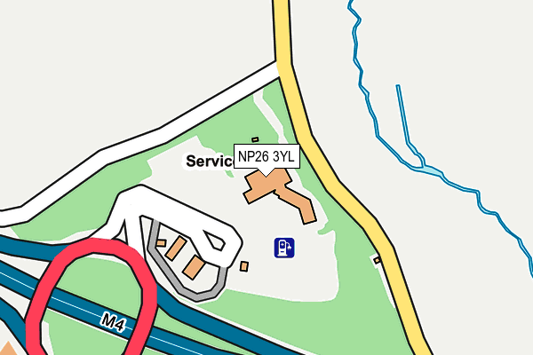
NP26 3YL is located in the Magor West electoral ward, within the unitary authority of Monmouthshire and the Welsh Parliamentary constituency of Newport East. The Local Health Board is Aneurin Bevan University and the police force is Gwent. This postcode has been in use since June 1999.


GetTheData
Source: OS OpenMap – Local (Ordnance Survey)
Source: OS VectorMap District (Ordnance Survey)
Licence: Open Government Licence (requires attribution)
| Easting | 342048 |
| Northing | 187982 |
| Latitude | 51.587698 |
| Longitude | -2.837879 |
GetTheData
Source: Open Postcode Geo
Licence: Open Government Licence
| Country | Wales |
| Postcode District | NP26 |
➜ See where NP26 is on a map | |
GetTheData
Source: Land Registry Price Paid Data
Licence: Open Government Licence
Elevation or altitude of NP26 3YL as distance above sea level:
| Metres | Feet | |
|---|---|---|
| Elevation | 20m | 66ft |
Elevation is measured from the approximate centre of the postcode, to the nearest point on an OS contour line from OS Terrain 50, which has contour spacing of ten vertical metres.
➜ How high above sea level am I? Find the elevation of your current position using your device's GPS.
GetTheData
Source: Open Postcode Elevation
Licence: Open Government Licence
| Ward | Magor West |
| Constituency | Newport East |
GetTheData
Source: ONS Postcode Database
Licence: Open Government Licence
| Services (Service Road) | Magor | 67m |
| Brewery (Newport Road) | Magor | 412m |
| Queen`s Gardens (Newport Road) | Magor | 489m |
| Brewery (Newport Road) | Magor | 531m |
| Blenheim Avenue (Newport Road) | Magor | 589m |
| Severn Tunnel Junction Station | 4.2km |
GetTheData
Source: NaPTAN
Licence: Open Government Licence
GetTheData
Source: ONS Postcode Database
Licence: Open Government Licence


➜ Get more ratings from the Food Standards Agency
GetTheData
Source: Food Standards Agency
Licence: FSA terms & conditions
| Last Collection | |||
|---|---|---|---|
| Location | Mon-Fri | Sat | Distance |
| Magor Post Office | 18:00 | 12:00 | 1,682m |
| Groeswen | 16:30 | 08:45 | 3,523m |
| Redwick | 16:00 | 08:45 | 3,916m |
GetTheData
Source: Dracos
Licence: Creative Commons Attribution-ShareAlike
The below table lists the International Territorial Level (ITL) codes (formerly Nomenclature of Territorial Units for Statistics (NUTS) codes) and Local Administrative Units (LAU) codes for NP26 3YL:
| ITL 1 Code | Name |
|---|---|
| TLL | Wales |
| ITL 2 Code | Name |
| TLL2 | East Wales |
| ITL 3 Code | Name |
| TLL21 | Monmouthshire and Newport |
| LAU 1 Code | Name |
| W06000021 | Monmouthshire |
GetTheData
Source: ONS Postcode Directory
Licence: Open Government Licence
The below table lists the Census Output Area (OA), Lower Layer Super Output Area (LSOA), and Middle Layer Super Output Area (MSOA) for NP26 3YL:
| Code | Name | |
|---|---|---|
| OA | W00008188 | |
| LSOA | W01001573 | Monmouthshire 011B |
| MSOA | W02000346 | Monmouthshire 011 |
GetTheData
Source: ONS Postcode Directory
Licence: Open Government Licence
| NP26 3HW | Langley Close | 414m |
| NP26 3JD | St Brides Road | 458m |
| NP26 3HX | St Brides Road | 476m |
| NP26 3BZ | Newport Road | 491m |
| NP26 3JB | St Brides Close | 545m |
| NP26 3BU | Queens Gardens | 558m |
| NP26 3LG | Netherwent View | 590m |
| NP26 3NY | Albion Way | 615m |
| NP26 3HP | The Gardens | 624m |
| NP26 3NA | Blenheim Gardens | 637m |
GetTheData
Source: Open Postcode Geo; Land Registry Price Paid Data
Licence: Open Government Licence