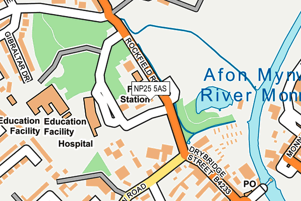
NP25 5AS lies on Drybridge Park in Monmouth. NP25 5AS is located in the Town electoral ward, within the unitary authority of Monmouthshire and the Welsh Parliamentary constituency of Monmouth. The Local Health Board is Aneurin Bevan University and the police force is Gwent. This postcode has been in use since June 1999.


GetTheData
Source: OS OpenMap – Local (Ordnance Survey)
Source: OS VectorMap District (Ordnance Survey)
Licence: Open Government Licence (requires attribution)
| Easting | 350220 |
| Northing | 212667 |
| Latitude | 51.810409 |
| Longitude | -2.723462 |
GetTheData
Source: Open Postcode Geo
Licence: Open Government Licence
| Street | Drybridge Park |
| Town/City | Monmouth |
| Country | Wales |
| Postcode District | NP25 |
➜ See where NP25 is on a map ➜ Where is Monmouth? | |
GetTheData
Source: Land Registry Price Paid Data
Licence: Open Government Licence
Elevation or altitude of NP25 5AS as distance above sea level:
| Metres | Feet | |
|---|---|---|
| Elevation | 20m | 66ft |
Elevation is measured from the approximate centre of the postcode, to the nearest point on an OS contour line from OS Terrain 50, which has contour spacing of ten vertical metres.
➜ How high above sea level am I? Find the elevation of your current position using your device's GPS.
GetTheData
Source: Open Postcode Elevation
Licence: Open Government Licence
| Ward | Town |
| Constituency | Monmouth |
GetTheData
Source: ONS Postcode Database
Licence: Open Government Licence
| Drybridge House (Rockfield Road) | Over Monnow | 67m |
| Drybridge House (Rockfield Road) | Over Monnow | 71m |
| Somerset Road (Wonastow Road) | Over Monnow | 151m |
| Somerset Road (Wonastow Road) | Over Monnow | 169m |
| Ancre Hill (Rockfield Road) | Monmouth | 284m |
GetTheData
Source: NaPTAN
Licence: Open Government Licence
| Percentage of properties with Next Generation Access | 100.0% |
| Percentage of properties with Superfast Broadband | 100.0% |
| Percentage of properties with Ultrafast Broadband | 0.0% |
| Percentage of properties with Full Fibre Broadband | 0.0% |
Superfast Broadband is between 30Mbps and 300Mbps
Ultrafast Broadband is > 300Mbps
| Median download speed | 14.7Mbps |
| Average download speed | 35.4Mbps |
| Maximum download speed | 80.00Mbps |
| Median upload speed | 5.5Mbps |
| Average upload speed | 8.5Mbps |
| Maximum upload speed | 20.00Mbps |
| Percentage of properties unable to receive 2Mbps | 0.0% |
| Percentage of properties unable to receive 5Mbps | 0.0% |
| Percentage of properties unable to receive 10Mbps | 0.0% |
| Percentage of properties unable to receive 30Mbps | 0.0% |
GetTheData
Source: Ofcom
Licence: Ofcom Terms of Use (requires attribution)
Estimated total energy consumption in NP25 5AS by fuel type, 2015.
| Consumption (kWh) | 72,405 |
|---|---|
| Meter count | 17 |
| Mean (kWh/meter) | 4,259 |
| Median (kWh/meter) | 3,628 |
| Consumption (kWh) | 21,129 |
|---|---|
| Meter count | 16 |
| Mean (kWh/meter) | 1,321 |
| Median (kWh/meter) | 1,003 |
GetTheData
Source: Postcode level gas estimates: 2015 (experimental)
Source: Postcode level electricity estimates: 2015 (experimental)
Licence: Open Government Licence
GetTheData
Source: ONS Postcode Database
Licence: Open Government Licence


➜ Get more ratings from the Food Standards Agency
GetTheData
Source: Food Standards Agency
Licence: FSA terms & conditions
| Last Collection | |||
|---|---|---|---|
| Location | Mon-Fri | Sat | Distance |
| Kings Fee | 17:00 | 12:00 | 286m |
| Victoria Estate | 17:00 | 11:30 | 393m |
| Monnow Street | 17:30 | 11:45 | 412m |
GetTheData
Source: Dracos
Licence: Creative Commons Attribution-ShareAlike
The below table lists the International Territorial Level (ITL) codes (formerly Nomenclature of Territorial Units for Statistics (NUTS) codes) and Local Administrative Units (LAU) codes for NP25 5AS:
| ITL 1 Code | Name |
|---|---|
| TLL | Wales |
| ITL 2 Code | Name |
| TLL2 | East Wales |
| ITL 3 Code | Name |
| TLL21 | Monmouthshire and Newport |
| LAU 1 Code | Name |
| W06000021 | Monmouthshire |
GetTheData
Source: ONS Postcode Directory
Licence: Open Government Licence
The below table lists the Census Output Area (OA), Lower Layer Super Output Area (LSOA), and Middle Layer Super Output Area (MSOA) for NP25 5AS:
| Code | Name | |
|---|---|---|
| OA | W00008102 | |
| LSOA | W01001553 | Monmouthshire 004B |
| MSOA | W02000339 | Monmouthshire 004 |
GetTheData
Source: ONS Postcode Directory
Licence: Open Government Licence
| NP25 5AF | Drybridge Terrace | 175m |
| NP25 5AD | Drybridge Street | 180m |
| NP25 5AE | Glenroyd Terrace | 209m |
| NP25 5DQ | Victoria Court | 212m |
| NP25 5AJ | Somerset Road | 227m |
| NP25 5AU | Rockfield Road | 230m |
| NP25 5AA | Drybridge Street | 236m |
| NP25 5DF | Williams Field Lane | 238m |
| NP25 3PT | The Oldway Centre | 246m |
| NP25 5FA | Bowen Gardens | 259m |
GetTheData
Source: Open Postcode Geo; Land Registry Price Paid Data
Licence: Open Government Licence