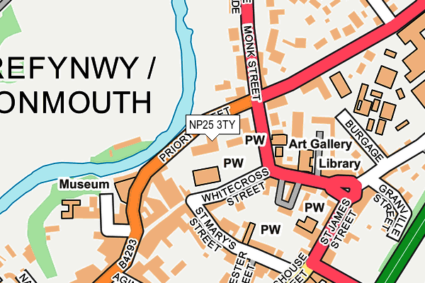
NP25 3TY is located in the Town electoral ward, within the unitary authority of Monmouthshire and the Welsh Parliamentary constituency of Monmouth. The Local Health Board is Aneurin Bevan University and the police force is Gwent. This postcode has been in use since June 1999.


GetTheData
Source: OS OpenMap – Local (Ordnance Survey)
Source: OS VectorMap District (Ordnance Survey)
Licence: Open Government Licence (requires attribution)
| Easting | 350890 |
| Northing | 213019 |
| Latitude | 51.813633 |
| Longitude | -2.713794 |
GetTheData
Source: Open Postcode Geo
Licence: Open Government Licence
| Country | Wales |
| Postcode District | NP25 |
➜ See where NP25 is on a map ➜ Where is Monmouth? | |
GetTheData
Source: Land Registry Price Paid Data
Licence: Open Government Licence
Elevation or altitude of NP25 3TY as distance above sea level:
| Metres | Feet | |
|---|---|---|
| Elevation | 20m | 66ft |
Elevation is measured from the approximate centre of the postcode, to the nearest point on an OS contour line from OS Terrain 50, which has contour spacing of ten vertical metres.
➜ How high above sea level am I? Find the elevation of your current position using your device's GPS.
GetTheData
Source: Open Postcode Elevation
Licence: Open Government Licence
| Ward | Town |
| Constituency | Monmouth |
GetTheData
Source: ONS Postcode Database
Licence: Open Government Licence
| Rolls Hall (St James` Square) | Monmouth | 175m |
| Rolls Hall (St James` Square) | Monmouth | 177m |
| Agincourt Square (Priory Street) | Monmouth | 178m |
| Agincourt Square (Priory Street) | Over Monnow | 184m |
| Clinic (Dixton Road) | Monmouth | 208m |
GetTheData
Source: NaPTAN
Licence: Open Government Licence
GetTheData
Source: ONS Postcode Database
Licence: Open Government Licence


➜ Get more ratings from the Food Standards Agency
GetTheData
Source: Food Standards Agency
Licence: FSA terms & conditions
| Last Collection | |||
|---|---|---|---|
| Location | Mon-Fri | Sat | Distance |
| Agincourt Square | 17:00 | 12:00 | 226m |
| The Parade | 17:30 | 11:00 | 238m |
| Monnow Street | 17:30 | 11:45 | 396m |
GetTheData
Source: Dracos
Licence: Creative Commons Attribution-ShareAlike
The below table lists the International Territorial Level (ITL) codes (formerly Nomenclature of Territorial Units for Statistics (NUTS) codes) and Local Administrative Units (LAU) codes for NP25 3TY:
| ITL 1 Code | Name |
|---|---|
| TLL | Wales |
| ITL 2 Code | Name |
| TLL2 | East Wales |
| ITL 3 Code | Name |
| TLL21 | Monmouthshire and Newport |
| LAU 1 Code | Name |
| W06000021 | Monmouthshire |
GetTheData
Source: ONS Postcode Directory
Licence: Open Government Licence
The below table lists the Census Output Area (OA), Lower Layer Super Output Area (LSOA), and Middle Layer Super Output Area (MSOA) for NP25 3TY:
| Code | Name | |
|---|---|---|
| OA | W00008104 | |
| LSOA | W01001554 | Monmouthshire 004C |
| MSOA | W02000339 | Monmouthshire 004 |
GetTheData
Source: ONS Postcode Directory
Licence: Open Government Licence
| NP25 3LR | Monk Street | 91m |
| NP25 3BZ | Whitecross Street | 95m |
| NP25 3BY | Whitecross Street | 95m |
| NP25 3DA | Powells Court | 102m |
| NP25 3NZ | Monk Street | 106m |
| NP25 3LW | Monk Street | 112m |
| NP25 3BR | Priory Street | 115m |
| NP25 3AE | Cwrt William Jones | 119m |
| NP25 3NY | Priory Street | 122m |
| NP25 3BX | Church Street | 127m |
GetTheData
Source: Open Postcode Geo; Land Registry Price Paid Data
Licence: Open Government Licence