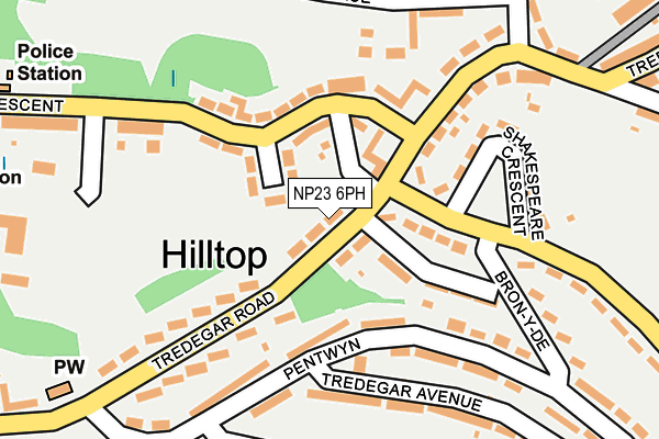
NP23 6PH is located in the Ebbw Vale North electoral ward, within the unitary authority of Blaenau Gwent and the Welsh Parliamentary constituency of Blaenau Gwent. The Local Health Board is Aneurin Bevan University and the police force is Gwent. This postcode has been in use since June 1999.


GetTheData
Source: OS OpenMap – Local (Ordnance Survey)
Source: OS VectorMap District (Ordnance Survey)
Licence: Open Government Licence (requires attribution)
| Easting | 316134 |
| Northing | 209559 |
| Latitude | 51.778390 |
| Longitude | -3.217031 |
GetTheData
Source: Open Postcode Geo
Licence: Open Government Licence
| Country | Wales |
| Postcode District | NP23 |
➜ See where NP23 is on a map ➜ Where is Ebbw Vale? | |
GetTheData
Source: Land Registry Price Paid Data
Licence: Open Government Licence
Elevation or altitude of NP23 6PH as distance above sea level:
| Metres | Feet | |
|---|---|---|
| Elevation | 360m | 1,181ft |
Elevation is measured from the approximate centre of the postcode, to the nearest point on an OS contour line from OS Terrain 50, which has contour spacing of ten vertical metres.
➜ How high above sea level am I? Find the elevation of your current position using your device's GPS.
GetTheData
Source: Open Postcode Elevation
Licence: Open Government Licence
| Ward | Ebbw Vale North |
| Constituency | Blaenau Gwent |
GetTheData
Source: ONS Postcode Database
Licence: Open Government Licence
| Shopping Centre (Tredegar Road) | Hilltop | 72m |
| Bron-y-de (Bryn Deri) | Hilltop | 162m |
| Bron-y-de (Bryn Deri) | Hilltop | 189m |
| Playground (Darby Crescent) | Mountain Air | 210m |
| Pentwyn | Hilltop | 232m |
| Ebbw Vale Town Station | 1km |
| Ebbw Vale Parkway Station | 2.8km |
| Pontlottyn Station | 5.5km |
GetTheData
Source: NaPTAN
Licence: Open Government Licence
| Percentage of properties with Next Generation Access | 100.0% |
| Percentage of properties with Superfast Broadband | 100.0% |
| Percentage of properties with Ultrafast Broadband | 0.0% |
| Percentage of properties with Full Fibre Broadband | 0.0% |
Superfast Broadband is between 30Mbps and 300Mbps
Ultrafast Broadband is > 300Mbps
| Median download speed | 40.0Mbps |
| Average download speed | 50.0Mbps |
| Maximum download speed | 80.00Mbps |
| Median upload speed | 10.0Mbps |
| Average upload speed | 12.2Mbps |
| Maximum upload speed | 20.00Mbps |
| Percentage of properties unable to receive 2Mbps | 0.0% |
| Percentage of properties unable to receive 5Mbps | 0.0% |
| Percentage of properties unable to receive 10Mbps | 0.0% |
| Percentage of properties unable to receive 30Mbps | 0.0% |
GetTheData
Source: Ofcom
Licence: Ofcom Terms of Use (requires attribution)
Estimated total energy consumption in NP23 6PH by fuel type, 2015.
| Consumption (kWh) | 159,931 |
|---|---|
| Meter count | 18 |
| Mean (kWh/meter) | 8,885 |
| Median (kWh/meter) | 10,433 |
| Consumption (kWh) | 38,584 |
|---|---|
| Meter count | 20 |
| Mean (kWh/meter) | 1,929 |
| Median (kWh/meter) | 1,573 |
GetTheData
Source: Postcode level gas estimates: 2015 (experimental)
Source: Postcode level electricity estimates: 2015 (experimental)
Licence: Open Government Licence
GetTheData
Source: ONS Postcode Database
Licence: Open Government Licence


➜ Get more ratings from the Food Standards Agency
GetTheData
Source: Food Standards Agency
Licence: FSA terms & conditions
| Last Collection | |||
|---|---|---|---|
| Location | Mon-Fri | Sat | Distance |
| Alma Street | 16:45 | 11:45 | 1,729m |
| Marine Street | 16:30 | 11:00 | 5,308m |
| King Street Post Office | 16:45 | 12:00 | 5,626m |
GetTheData
Source: Dracos
Licence: Creative Commons Attribution-ShareAlike
The below table lists the International Territorial Level (ITL) codes (formerly Nomenclature of Territorial Units for Statistics (NUTS) codes) and Local Administrative Units (LAU) codes for NP23 6PH:
| ITL 1 Code | Name |
|---|---|
| TLL | Wales |
| ITL 2 Code | Name |
| TLL1 | West Wales and The Valleys |
| ITL 3 Code | Name |
| TLL16 | Gwent Valleys |
| LAU 1 Code | Name |
| W06000019 | Blaenau Gwent |
GetTheData
Source: ONS Postcode Directory
Licence: Open Government Licence
The below table lists the Census Output Area (OA), Lower Layer Super Output Area (LSOA), and Middle Layer Super Output Area (MSOA) for NP23 6PH:
| Code | Name | |
|---|---|---|
| OA | W00007610 | |
| LSOA | W01001457 | Blaenau Gwent 004D |
| MSOA | W02000317 | Blaenau Gwent 004 |
GetTheData
Source: ONS Postcode Directory
Licence: Open Government Licence
| NP23 6QB | Trenant | 56m |
| NP23 6PJ | Hill Top | 59m |
| NP23 6QA | Darby Crescent | 110m |
| NP23 6PA | Pentwyn | 127m |
| NP23 6ND | Brynteg Terrace | 159m |
| NP23 6NX | Bron Y De | 165m |
| NP23 6NZ | Pentwyn | 182m |
| NP23 6PU | Tredegar Road | 185m |
| NP23 6NT | Shakespeare Crescent | 188m |
| NP23 6PQ | Tredegar Road | 198m |
GetTheData
Source: Open Postcode Geo; Land Registry Price Paid Data
Licence: Open Government Licence