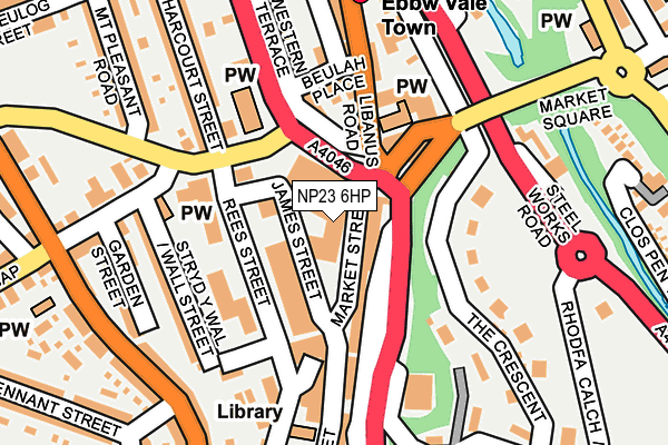
NP23 6HP is located in the Ebbw Vale South electoral ward, within the unitary authority of Blaenau Gwent and the Welsh Parliamentary constituency of Blaenau Gwent. The Local Health Board is Aneurin Bevan University and the police force is Gwent. This postcode has been in use since June 1999.


GetTheData
Source: OS OpenMap – Local (Ordnance Survey)
Source: OS VectorMap District (Ordnance Survey)
Licence: Open Government Licence (requires attribution)
| Easting | 316791 |
| Northing | 209792 |
| Latitude | 51.780587 |
| Longitude | -3.207574 |
GetTheData
Source: Open Postcode Geo
Licence: Open Government Licence
| Country | Wales |
| Postcode District | NP23 |
➜ See where NP23 is on a map ➜ Where is Ebbw Vale? | |
GetTheData
Source: Land Registry Price Paid Data
Licence: Open Government Licence
Elevation or altitude of NP23 6HP as distance above sea level:
| Metres | Feet | |
|---|---|---|
| Elevation | 300m | 984ft |
Elevation is measured from the approximate centre of the postcode, to the nearest point on an OS contour line from OS Terrain 50, which has contour spacing of ten vertical metres.
➜ How high above sea level am I? Find the elevation of your current position using your device's GPS.
GetTheData
Source: Open Postcode Elevation
Licence: Open Government Licence
| Ward | Ebbw Vale South |
| Constituency | Blaenau Gwent |
GetTheData
Source: ONS Postcode Database
Licence: Open Government Licence
| Inner Bypass (A4046) | Ebbw Vale | 72m |
| Inner Bypass (A4046) | Ebbw Vale | 94m |
| Inner Bypass (A4046) | Ebbw Vale | 95m |
| Inner Bypass (A4046) | Ebbw Vale | 110m |
| Inner Bypass (Ebbw Vale Inner Bypass) | Ebbw Vale | 115m |
| Ebbw Vale Town Station | 0.6km |
| Ebbw Vale Parkway Station | 2.7km |
| Pontlottyn Station | 6.2km |
GetTheData
Source: NaPTAN
Licence: Open Government Licence
GetTheData
Source: ONS Postcode Database
Licence: Open Government Licence


➜ Get more ratings from the Food Standards Agency
GetTheData
Source: Food Standards Agency
Licence: FSA terms & conditions
| Last Collection | |||
|---|---|---|---|
| Location | Mon-Fri | Sat | Distance |
| Alma Street | 16:45 | 11:45 | 1,724m |
| King Street Post Office | 16:45 | 12:00 | 4,942m |
| Marine Street | 16:30 | 11:00 | 5,251m |
GetTheData
Source: Dracos
Licence: Creative Commons Attribution-ShareAlike
The below table lists the International Territorial Level (ITL) codes (formerly Nomenclature of Territorial Units for Statistics (NUTS) codes) and Local Administrative Units (LAU) codes for NP23 6HP:
| ITL 1 Code | Name |
|---|---|
| TLL | Wales |
| ITL 2 Code | Name |
| TLL1 | West Wales and The Valleys |
| ITL 3 Code | Name |
| TLL16 | Gwent Valleys |
| LAU 1 Code | Name |
| W06000019 | Blaenau Gwent |
GetTheData
Source: ONS Postcode Directory
Licence: Open Government Licence
The below table lists the Census Output Area (OA), Lower Layer Super Output Area (LSOA), and Middle Layer Super Output Area (MSOA) for NP23 6HP:
| Code | Name | |
|---|---|---|
| OA | W00007624 | |
| LSOA | W01001461 | Blaenau Gwent 007F |
| MSOA | W02000320 | Blaenau Gwent 007 |
GetTheData
Source: ONS Postcode Directory
Licence: Open Government Licence
| NP23 6HJ | Market Street | 38m |
| NP23 6HL | Market Street | 88m |
| NP23 6YH | Market Street | 93m |
| NP23 6HR | Market Square | 101m |
| NP23 6JQ | Tredegar Road | 128m |
| NP23 6ET | Beulah Place | 139m |
| NP23 6HF | Aynho Place | 148m |
| NP23 6LS | Wall Street | 159m |
| NP23 6HS | Westend Terrace | 162m |
| NP23 6EG | The Crescent | 164m |
GetTheData
Source: Open Postcode Geo; Land Registry Price Paid Data
Licence: Open Government Licence