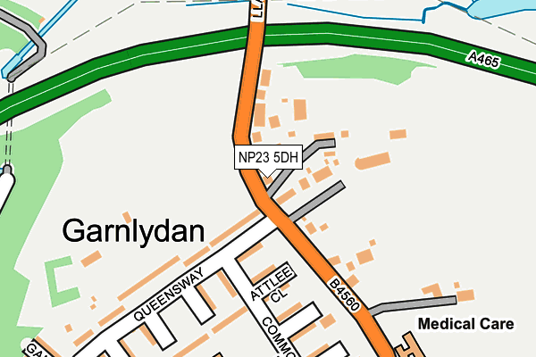
NP23 5DH lies on Llangynidr Road in Beaufort, Ebbw Vale. NP23 5DH is located in the Rassau and Garnlydan electoral ward, within the unitary authority of Blaenau Gwent and the Welsh Parliamentary constituency of Blaenau Gwent. The Local Health Board is Aneurin Bevan University and the police force is Gwent. This postcode has been in use since June 1999.


GetTheData
Source: OS OpenMap – Local (Ordnance Survey)
Source: OS VectorMap District (Ordnance Survey)
Licence: Open Government Licence (requires attribution)
| Easting | 316728 |
| Northing | 212687 |
| Latitude | 51.806596 |
| Longitude | -3.209175 |
GetTheData
Source: Open Postcode Geo
Licence: Open Government Licence
| Street | Llangynidr Road |
| Locality | Beaufort |
| Town/City | Ebbw Vale |
| Country | Wales |
| Postcode District | NP23 |
➜ See where NP23 is on a map ➜ Where is Ebbw Vale? | |
GetTheData
Source: Land Registry Price Paid Data
Licence: Open Government Licence
Elevation or altitude of NP23 5DH as distance above sea level:
| Metres | Feet | |
|---|---|---|
| Elevation | 400m | 1,312ft |
Elevation is measured from the approximate centre of the postcode, to the nearest point on an OS contour line from OS Terrain 50, which has contour spacing of ten vertical metres.
➜ How high above sea level am I? Find the elevation of your current position using your device's GPS.
GetTheData
Source: Open Postcode Elevation
Licence: Open Government Licence
| Ward | Rassau And Garnlydan |
| Constituency | Blaenau Gwent |
GetTheData
Source: ONS Postcode Database
Licence: Open Government Licence
| Fernbank Close (Queensway) | Garn Lydan | 130m |
| Bank House (Llangynidr Road) | Garn Lydan | 239m |
| Bank House (Llangynidr Road) | Garn Lydan | 242m |
| Post Office (Queensway) | Garn Lydan | 303m |
| Post Office (Queensway) | Garn Lydan | 319m |
| Ebbw Vale Town Station | 3.4km |
GetTheData
Source: NaPTAN
Licence: Open Government Licence
| Percentage of properties with Next Generation Access | 100.0% |
| Percentage of properties with Superfast Broadband | 100.0% |
| Percentage of properties with Ultrafast Broadband | 0.0% |
| Percentage of properties with Full Fibre Broadband | 0.0% |
Superfast Broadband is between 30Mbps and 300Mbps
Ultrafast Broadband is > 300Mbps
| Percentage of properties unable to receive 2Mbps | 0.0% |
| Percentage of properties unable to receive 5Mbps | 0.0% |
| Percentage of properties unable to receive 10Mbps | 0.0% |
| Percentage of properties unable to receive 30Mbps | 0.0% |
GetTheData
Source: Ofcom
Licence: Ofcom Terms of Use (requires attribution)
GetTheData
Source: ONS Postcode Database
Licence: Open Government Licence


➜ Get more ratings from the Food Standards Agency
GetTheData
Source: Food Standards Agency
Licence: FSA terms & conditions
| Last Collection | |||
|---|---|---|---|
| Location | Mon-Fri | Sat | Distance |
| King Street Post Office | 16:45 | 12:00 | 4,303m |
| Alma Street | 16:45 | 11:45 | 4,612m |
| Hillside Road Llangattock | 16:30 | 09:00 | 6,217m |
GetTheData
Source: Dracos
Licence: Creative Commons Attribution-ShareAlike
The below table lists the International Territorial Level (ITL) codes (formerly Nomenclature of Territorial Units for Statistics (NUTS) codes) and Local Administrative Units (LAU) codes for NP23 5DH:
| ITL 1 Code | Name |
|---|---|
| TLL | Wales |
| ITL 2 Code | Name |
| TLL1 | West Wales and The Valleys |
| ITL 3 Code | Name |
| TLL16 | Gwent Valleys |
| LAU 1 Code | Name |
| W06000019 | Blaenau Gwent |
GetTheData
Source: ONS Postcode Directory
Licence: Open Government Licence
The below table lists the Census Output Area (OA), Lower Layer Super Output Area (LSOA), and Middle Layer Super Output Area (MSOA) for NP23 5DH:
| Code | Name | |
|---|---|---|
| OA | W00007534 | |
| LSOA | W01001441 | Blaenau Gwent 001B |
| MSOA | W02000314 | Blaenau Gwent 001 |
GetTheData
Source: ONS Postcode Directory
Licence: Open Government Licence
| NP23 5EY | Llangynidr Road | 38m |
| NP23 5EP | Queensway | 78m |
| NP23 5ES | Attlee Close | 127m |
| NP23 5ER | Commonwealth Road | 135m |
| NP23 5ET | Keir Hardie Close | 176m |
| NP23 5EJ | Queensway | 204m |
| NP23 5EN | Beechfield Close | 221m |
| NP23 5EU | Gorsedd Close | 226m |
| NP23 5EL | Lansdowne Close | 251m |
| NP23 5EE | Queensway | 311m |
GetTheData
Source: Open Postcode Geo; Land Registry Price Paid Data
Licence: Open Government Licence