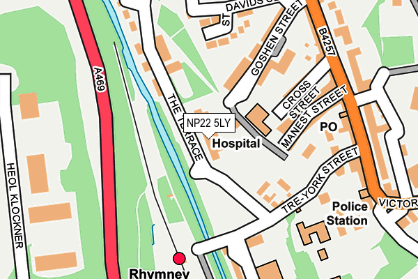
NP22 5LY lies on The Terrace in Rhymney, Tredegar. NP22 5LY is located in the Twyn Carno electoral ward, within the unitary authority of Caerphilly and the Welsh Parliamentary constituency of Merthyr Tydfil and Rhymney. The Local Health Board is Aneurin Bevan University and the police force is Gwent. This postcode has been in use since June 1999.


GetTheData
Source: OS OpenMap – Local (Ordnance Survey)
Source: OS VectorMap District (Ordnance Survey)
Licence: Open Government Licence (requires attribution)
| Easting | 311143 |
| Northing | 207631 |
| Latitude | 51.760288 |
| Longitude | -3.288861 |
GetTheData
Source: Open Postcode Geo
Licence: Open Government Licence
| Street | The Terrace |
| Locality | Rhymney |
| Town/City | Tredegar |
| Country | Wales |
| Postcode District | NP22 |
➜ See where NP22 is on a map ➜ Where is Rhymney? | |
GetTheData
Source: Land Registry Price Paid Data
Licence: Open Government Licence
Elevation or altitude of NP22 5LY as distance above sea level:
| Metres | Feet | |
|---|---|---|
| Elevation | 270m | 886ft |
Elevation is measured from the approximate centre of the postcode, to the nearest point on an OS contour line from OS Terrain 50, which has contour spacing of ten vertical metres.
➜ How high above sea level am I? Find the elevation of your current position using your device's GPS.
GetTheData
Source: Open Postcode Elevation
Licence: Open Government Licence
| Ward | Twyn Carno |
| Constituency | Merthyr Tydfil And Rhymney |
GetTheData
Source: ONS Postcode Database
Licence: Open Government Licence
| Station (Station Approach) | Rhymney | 152m |
| The Royal (High Street) | Rhymney | 205m |
| The Royal (High Street) | Rhymney | 218m |
| Library (Victoria Road) | Rhymney | 322m |
| Library (Victoria Road) | Rhymney | 327m |
| Rhymney Station | 0.2km |
| Pontlottyn Station | 1.7km |
| Tir-phil Station | 5.3km |
GetTheData
Source: NaPTAN
Licence: Open Government Licence
| Percentage of properties with Next Generation Access | 100.0% |
| Percentage of properties with Superfast Broadband | 100.0% |
| Percentage of properties with Ultrafast Broadband | 0.0% |
| Percentage of properties with Full Fibre Broadband | 0.0% |
Superfast Broadband is between 30Mbps and 300Mbps
Ultrafast Broadband is > 300Mbps
| Median download speed | 16.5Mbps |
| Average download speed | 21.8Mbps |
| Maximum download speed | 78.12Mbps |
| Median upload speed | 1.1Mbps |
| Average upload speed | 4.0Mbps |
| Maximum upload speed | 19.53Mbps |
| Percentage of properties unable to receive 2Mbps | 0.0% |
| Percentage of properties unable to receive 5Mbps | 0.0% |
| Percentage of properties unable to receive 10Mbps | 0.0% |
| Percentage of properties unable to receive 30Mbps | 0.0% |
GetTheData
Source: Ofcom
Licence: Ofcom Terms of Use (requires attribution)
Estimated total energy consumption in NP22 5LY by fuel type, 2015.
| Consumption (kWh) | 368,445 |
|---|---|
| Meter count | 15 |
| Mean (kWh/meter) | 24,563 |
| Median (kWh/meter) | 23,266 |
| Consumption (kWh) | 55,997 |
|---|---|
| Meter count | 15 |
| Mean (kWh/meter) | 3,733 |
| Median (kWh/meter) | 3,127 |
GetTheData
Source: Postcode level gas estimates: 2015 (experimental)
Source: Postcode level electricity estimates: 2015 (experimental)
Licence: Open Government Licence
GetTheData
Source: ONS Postcode Database
Licence: Open Government Licence


➜ Get more ratings from the Food Standards Agency
GetTheData
Source: Food Standards Agency
Licence: FSA terms & conditions
The below table lists the International Territorial Level (ITL) codes (formerly Nomenclature of Territorial Units for Statistics (NUTS) codes) and Local Administrative Units (LAU) codes for NP22 5LY:
| ITL 1 Code | Name |
|---|---|
| TLL | Wales |
| ITL 2 Code | Name |
| TLL1 | West Wales and The Valleys |
| ITL 3 Code | Name |
| TLL16 | Gwent Valleys |
| LAU 1 Code | Name |
| W06000018 | Caerphilly |
GetTheData
Source: ONS Postcode Directory
Licence: Open Government Licence
The below table lists the Census Output Area (OA), Lower Layer Super Output Area (LSOA), and Middle Layer Super Output Area (MSOA) for NP22 5LY:
| Code | Name | |
|---|---|---|
| OA | W00007199 | |
| LSOA | W01001375 | Caerphilly 001B |
| MSOA | W02000290 | Caerphilly 001 |
GetTheData
Source: ONS Postcode Directory
Licence: Open Government Licence
| NP22 5NE | Goshen Street | 82m |
| NP22 5BR | The Terrace | 110m |
| NP22 5NF | Goshen Street | 134m |
| NP22 5NL | St Davids Close | 153m |
| NP22 5NH | Manest Street | 154m |
| NP22 5ND | Cross Street | 165m |
| NP22 5LR | Tre York | 188m |
| NP22 5NB | High Street | 204m |
| NP22 5LP | High Street | 210m |
| NP22 5LS | The Lawn | 225m |
GetTheData
Source: Open Postcode Geo; Land Registry Price Paid Data
Licence: Open Government Licence