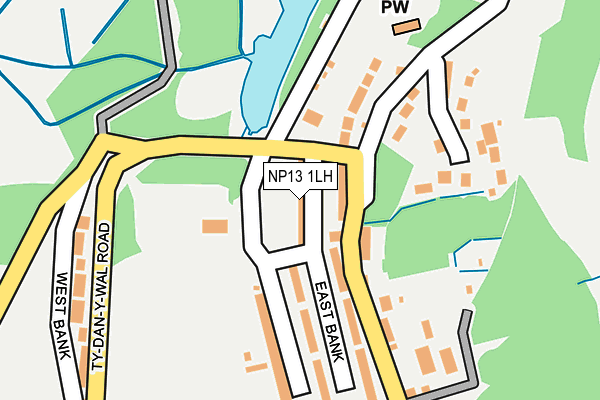
NP13 1LH is located in the Cwmtillery electoral ward, within the unitary authority of Blaenau Gwent and the Welsh Parliamentary constituency of Blaenau Gwent. The Local Health Board is Aneurin Bevan University and the police force is Gwent. This postcode has been in use since June 1999.


GetTheData
Source: OS OpenMap – Local (Ordnance Survey)
Source: OS VectorMap District (Ordnance Survey)
Licence: Open Government Licence (requires attribution)
| Easting | 321810 |
| Northing | 206019 |
| Latitude | 51.747391 |
| Longitude | -3.133978 |
GetTheData
Source: Open Postcode Geo
Licence: Open Government Licence
| Country | Wales |
| Postcode District | NP13 |
➜ See where NP13 is on a map ➜ Where is Abertillery? | |
GetTheData
Source: Land Registry Price Paid Data
Licence: Open Government Licence
Elevation or altitude of NP13 1LH as distance above sea level:
| Metres | Feet | |
|---|---|---|
| Elevation | 300m | 984ft |
Elevation is measured from the approximate centre of the postcode, to the nearest point on an OS contour line from OS Terrain 50, which has contour spacing of ten vertical metres.
➜ How high above sea level am I? Find the elevation of your current position using your device's GPS.
GetTheData
Source: Open Postcode Elevation
Licence: Open Government Licence
| Ward | Cwmtillery |
| Constituency | Blaenau Gwent |
GetTheData
Source: ONS Postcode Database
Licence: Open Government Licence
| Lake (Ty Dan Y Wal Road) | Cwmtillery | 56m |
| Church Hall (Bryn Terrace) | Cwmtillery | 58m |
| Church Hall (Bryn Terrace) | Cwmtillery | 62m |
| Lake (Ty Dan Y Wal Road) | Cwmtillery | 73m |
| Ty Dan-y-wal Top (Ty Dan-y-wal) | West Bank | 155m |
| Ebbw Vale Parkway Station | 4.4km |
| Ebbw Vale Town Station | 5.7km |
GetTheData
Source: NaPTAN
Licence: Open Government Licence
| Percentage of properties with Next Generation Access | 100.0% |
| Percentage of properties with Superfast Broadband | 16.7% |
| Percentage of properties with Ultrafast Broadband | 0.0% |
| Percentage of properties with Full Fibre Broadband | 0.0% |
Superfast Broadband is between 30Mbps and 300Mbps
Ultrafast Broadband is > 300Mbps
| Median download speed | 8.7Mbps |
| Average download speed | 12.6Mbps |
| Maximum download speed | 24.30Mbps |
| Median upload speed | 1.0Mbps |
| Average upload speed | 1.7Mbps |
| Maximum upload speed | 5.28Mbps |
| Percentage of properties unable to receive 2Mbps | 0.0% |
| Percentage of properties unable to receive 5Mbps | 0.0% |
| Percentage of properties unable to receive 10Mbps | 0.0% |
| Percentage of properties unable to receive 30Mbps | 83.3% |
GetTheData
Source: Ofcom
Licence: Ofcom Terms of Use (requires attribution)
Estimated total energy consumption in NP13 1LH by fuel type, 2015.
| Consumption (kWh) | 146,839 |
|---|---|
| Meter count | 12 |
| Mean (kWh/meter) | 12,237 |
| Median (kWh/meter) | 10,948 |
| Consumption (kWh) | 16,834 |
|---|---|
| Meter count | 9 |
| Mean (kWh/meter) | 1,870 |
| Median (kWh/meter) | 1,950 |
GetTheData
Source: Postcode level gas estimates: 2015 (experimental)
Source: Postcode level electricity estimates: 2015 (experimental)
Licence: Open Government Licence
GetTheData
Source: ONS Postcode Database
Licence: Open Government Licence


➜ Get more ratings from the Food Standards Agency
GetTheData
Source: Food Standards Agency
Licence: FSA terms & conditions
| Last Collection | |||
|---|---|---|---|
| Location | Mon-Fri | Sat | Distance |
| Marine Street | 16:30 | 11:00 | 3,392m |
| Bryn Terrace | 16:15 | 11:30 | 4,726m |
| Alma Street | 16:45 | 11:45 | 5,199m |
GetTheData
Source: Dracos
Licence: Creative Commons Attribution-ShareAlike
The below table lists the International Territorial Level (ITL) codes (formerly Nomenclature of Territorial Units for Statistics (NUTS) codes) and Local Administrative Units (LAU) codes for NP13 1LH:
| ITL 1 Code | Name |
|---|---|
| TLL | Wales |
| ITL 2 Code | Name |
| TLL1 | West Wales and The Valleys |
| ITL 3 Code | Name |
| TLL16 | Gwent Valleys |
| LAU 1 Code | Name |
| W06000019 | Blaenau Gwent |
GetTheData
Source: ONS Postcode Directory
Licence: Open Government Licence
The below table lists the Census Output Area (OA), Lower Layer Super Output Area (LSOA), and Middle Layer Super Output Area (MSOA) for NP13 1LH:
| Code | Name | |
|---|---|---|
| OA | W00007599 | |
| LSOA | W01001454 | Blaenau Gwent 008E |
| MSOA | W02000321 | Blaenau Gwent 008 |
GetTheData
Source: ONS Postcode Directory
Licence: Open Government Licence
| NP13 1LQ | Palace Row | 45m |
| NP13 1LG | Bryn Terrace | 77m |
| NP13 1LU | Lake Villas | 90m |
| NP13 1LS | 121m | |
| NP13 1LL | East Side Row | 127m |
| NP13 1LJ | East Side Row | 135m |
| NP13 1LF | Gladstone Buildings | 150m |
| NP13 1LW | Brookside Row | 164m |
| NP13 1NS | Gwastod Farm | 182m |
| NP13 1LE | Bristol Buildings | 211m |
GetTheData
Source: Open Postcode Geo; Land Registry Price Paid Data
Licence: Open Government Licence