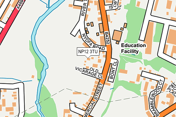
NP12 3TU lies on Old Vicarage Close in Pengam, Blackwood. NP12 3TU is located in the Cefn Fforest and Pengam electoral ward, within the unitary authority of Caerphilly and the Welsh Parliamentary constituency of Islwyn. The Local Health Board is Aneurin Bevan University and the police force is Gwent. This postcode has been in use since June 1999.


GetTheData
Source: OS OpenMap – Local (Ordnance Survey)
Source: OS VectorMap District (Ordnance Survey)
Licence: Open Government Licence (requires attribution)
| Easting | 315456 |
| Northing | 197289 |
| Latitude | 51.667995 |
| Longitude | -3.223882 |
GetTheData
Source: Open Postcode Geo
Licence: Open Government Licence
| Street | Old Vicarage Close |
| Locality | Pengam |
| Town/City | Blackwood |
| Country | Wales |
| Postcode District | NP12 |
➜ See where NP12 is on a map ➜ Where is Pengam? | |
GetTheData
Source: Land Registry Price Paid Data
Licence: Open Government Licence
Elevation or altitude of NP12 3TU as distance above sea level:
| Metres | Feet | |
|---|---|---|
| Elevation | 140m | 459ft |
Elevation is measured from the approximate centre of the postcode, to the nearest point on an OS contour line from OS Terrain 50, which has contour spacing of ten vertical metres.
➜ How high above sea level am I? Find the elevation of your current position using your device's GPS.
GetTheData
Source: Open Postcode Elevation
Licence: Open Government Licence
| Ward | Cefn Fforest And Pengam |
| Constituency | Islwyn |
GetTheData
Source: ONS Postcode Database
Licence: Open Government Licence
2015 17 JUL £289,995 |
2015 6 MAR £300,000 |
GetTheData
Source: HM Land Registry Price Paid Data
Licence: Contains HM Land Registry data © Crown copyright and database right 2025. This data is licensed under the Open Government Licence v3.0.
| Bont Close (Commercial Street) | Pengam | 71m |
| Bont Close (Commercial Street) | Pengam | 77m |
| St David`s Church (Commercial Street) | Pengam | 207m |
| St David`s Church (Commercial Street) | Pengam | 224m |
| Smith's Arms (Commercial Street) | Pengam | 236m |
| Pengam Station | 0.5km |
| Gilfach Fargoed Station | 1.8km |
| Hengoed Station | 2.3km |
GetTheData
Source: NaPTAN
Licence: Open Government Licence
| Percentage of properties with Next Generation Access | 100.0% |
| Percentage of properties with Superfast Broadband | 100.0% |
| Percentage of properties with Ultrafast Broadband | 0.0% |
| Percentage of properties with Full Fibre Broadband | 0.0% |
Superfast Broadband is between 30Mbps and 300Mbps
Ultrafast Broadband is > 300Mbps
| Percentage of properties unable to receive 2Mbps | 0.0% |
| Percentage of properties unable to receive 5Mbps | 0.0% |
| Percentage of properties unable to receive 10Mbps | 0.0% |
| Percentage of properties unable to receive 30Mbps | 0.0% |
GetTheData
Source: Ofcom
Licence: Ofcom Terms of Use (requires attribution)
GetTheData
Source: ONS Postcode Database
Licence: Open Government Licence


➜ Get more ratings from the Food Standards Agency
GetTheData
Source: Food Standards Agency
Licence: FSA terms & conditions
| Last Collection | |||
|---|---|---|---|
| Location | Mon-Fri | Sat | Distance |
| Fleur De Lys Village | 16:00 | 11:00 | 277m |
| St Davids Industrial Estate | 16:15 | 11:00 | 345m |
| Glanynant Post Office | 16:15 | 11:00 | 425m |
GetTheData
Source: Dracos
Licence: Creative Commons Attribution-ShareAlike
The below table lists the International Territorial Level (ITL) codes (formerly Nomenclature of Territorial Units for Statistics (NUTS) codes) and Local Administrative Units (LAU) codes for NP12 3TU:
| ITL 1 Code | Name |
|---|---|
| TLL | Wales |
| ITL 2 Code | Name |
| TLL1 | West Wales and The Valleys |
| ITL 3 Code | Name |
| TLL16 | Gwent Valleys |
| LAU 1 Code | Name |
| W06000018 | Caerphilly |
GetTheData
Source: ONS Postcode Directory
Licence: Open Government Licence
The below table lists the Census Output Area (OA), Lower Layer Super Output Area (LSOA), and Middle Layer Super Output Area (MSOA) for NP12 3TU:
| Code | Name | |
|---|---|---|
| OA | W00007275 | |
| LSOA | W01001387 | Caerphilly 007C |
| MSOA | W02000296 | Caerphilly 007 |
GetTheData
Source: ONS Postcode Directory
Licence: Open Government Licence
| NP12 3SX | Nydfa Road | 34m |
| NP12 3TX | Commercial Street | 107m |
| NP12 3ST | Commercial Street | 113m |
| NP12 3SJ | Commercial Street | 172m |
| NP12 3XA | Herons View | 183m |
| NP12 3XB | River Terrace | 196m |
| NP12 3WA | Glan Yr Afon Lane | 245m |
| NP12 3SS | Post Office Buildings | 248m |
| NP12 3XY | Bont Cottages | 257m |
| NP12 3TY | St Davids Road | 258m |
GetTheData
Source: Open Postcode Geo; Land Registry Price Paid Data
Licence: Open Government Licence