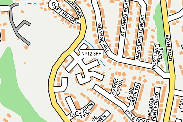
NP12 3FH is located in the Cefn Fforest and Pengam electoral ward, within the unitary authority of Caerphilly and the Welsh Parliamentary constituency of Islwyn. The Local Health Board is Aneurin Bevan University and the police force is Gwent. This postcode has been in use since June 1999.


GetTheData
Source: OS OpenMap – Local (Ordnance Survey)
Source: OS VectorMap District (Ordnance Survey)
Licence: Open Government Licence (requires attribution)
| Easting | 316327 |
| Northing | 196869 |
| Latitude | 51.664347 |
| Longitude | -3.211181 |
GetTheData
Source: Open Postcode Geo
Licence: Open Government Licence
| Country | Wales |
| Postcode District | NP12 |
➜ See where NP12 is on a map ➜ Where is Blackwood? | |
GetTheData
Source: Land Registry Price Paid Data
Licence: Open Government Licence
Elevation or altitude of NP12 3FH as distance above sea level:
| Metres | Feet | |
|---|---|---|
| Elevation | 210m | 689ft |
Elevation is measured from the approximate centre of the postcode, to the nearest point on an OS contour line from OS Terrain 50, which has contour spacing of ten vertical metres.
➜ How high above sea level am I? Find the elevation of your current position using your device's GPS.
GetTheData
Source: Open Postcode Elevation
Licence: Open Government Licence
| Ward | Cefn Fforest And Pengam |
| Constituency | Islwyn |
GetTheData
Source: ONS Postcode Database
Licence: Open Government Licence
| Upper Trelyn (Heol Y Dderwen) | Upper Trelyn | 78m |
| Upper Trelyn (Heol Y Dderwen) | Upper Trelyn | 84m |
| Trelyn Gardens (Heol Y Dderwen) | Upper Trelyn | 218m |
| Trelyn Gardens (Heol Y Dderwen) | Upper Trelyn | 221m |
| Heol Y Dderwen Junction (Fair View) | Fair View | 290m |
| Pengam Station | 1.5km |
| Hengoed Station | 2.1km |
| Gilfach Fargoed Station | 2.5km |
GetTheData
Source: NaPTAN
Licence: Open Government Licence
| Percentage of properties with Next Generation Access | 100.0% |
| Percentage of properties with Superfast Broadband | 100.0% |
| Percentage of properties with Ultrafast Broadband | 0.0% |
| Percentage of properties with Full Fibre Broadband | 0.0% |
Superfast Broadband is between 30Mbps and 300Mbps
Ultrafast Broadband is > 300Mbps
| Percentage of properties unable to receive 2Mbps | 0.0% |
| Percentage of properties unable to receive 5Mbps | 0.0% |
| Percentage of properties unable to receive 10Mbps | 0.0% |
| Percentage of properties unable to receive 30Mbps | 0.0% |
GetTheData
Source: Ofcom
Licence: Ofcom Terms of Use (requires attribution)
Estimated total energy consumption in NP12 3FH by fuel type, 2015.
| Consumption (kWh) | 73,203 |
|---|---|
| Meter count | 10 |
| Mean (kWh/meter) | 7,320 |
| Median (kWh/meter) | 7,577 |
| Consumption (kWh) | 18,753 |
|---|---|
| Meter count | 10 |
| Mean (kWh/meter) | 1,875 |
| Median (kWh/meter) | 1,721 |
GetTheData
Source: Postcode level gas estimates: 2015 (experimental)
Source: Postcode level electricity estimates: 2015 (experimental)
Licence: Open Government Licence
GetTheData
Source: ONS Postcode Database
Licence: Open Government Licence


➜ Get more ratings from the Food Standards Agency
GetTheData
Source: Food Standards Agency
Licence: FSA terms & conditions
| Last Collection | |||
|---|---|---|---|
| Location | Mon-Fri | Sat | Distance |
| St Davids Industrial Estate | 16:15 | 11:00 | 759m |
| Fleur De Lys Post Office | 17:00 | 12:00 | 803m |
| Fleur De Lys Village | 16:00 | 11:00 | 930m |
GetTheData
Source: Dracos
Licence: Creative Commons Attribution-ShareAlike
The below table lists the International Territorial Level (ITL) codes (formerly Nomenclature of Territorial Units for Statistics (NUTS) codes) and Local Administrative Units (LAU) codes for NP12 3FH:
| ITL 1 Code | Name |
|---|---|
| TLL | Wales |
| ITL 2 Code | Name |
| TLL1 | West Wales and The Valleys |
| ITL 3 Code | Name |
| TLL16 | Gwent Valleys |
| LAU 1 Code | Name |
| W06000018 | Caerphilly |
GetTheData
Source: ONS Postcode Directory
Licence: Open Government Licence
The below table lists the Census Output Area (OA), Lower Layer Super Output Area (LSOA), and Middle Layer Super Output Area (MSOA) for NP12 3FH:
| Code | Name | |
|---|---|---|
| OA | W00007092 | |
| LSOA | W01001353 | Caerphilly 007B |
| MSOA | W02000296 | Caerphilly 007 |
GetTheData
Source: ONS Postcode Directory
Licence: Open Government Licence
| NP12 3FJ | Brisbane Court | 65m |
| NP12 3PE | Grange Hill | 105m |
| NP12 3QU | Gardd Jolyon | 124m |
| NP12 3PF | Grange Hill | 134m |
| NP12 3PG | St Annes Road | 155m |
| NP12 3PH | Mandeville Road | 180m |
| NP12 3QR | Rhys Road | 185m |
| NP12 3QT | Clos Carolyn | 190m |
| NP12 3PJ | Portland Place | 199m |
| NP12 3LR | Cwrt Hendre | 206m |
GetTheData
Source: Open Postcode Geo; Land Registry Price Paid Data
Licence: Open Government Licence